Kaw City, Oklahoma

Last updated

Kaw City, Oklahoma
Kaw City Santa Fe Depot.jpg
The 1903 Santa Fe Depot, moved before the original townsite was flooded, now part of the Kaw City Museum.
OKMap-doton-KawCity.PNG
Location of Kaw City, Oklahoma
Coordinates: 36°46′03″N96°52′00″W / 36.76750°N 96.86667°W / 36.76750; -96.86667 [1]
Country United States
State Oklahoma
County Kay
Area
[2]
  Total6.12 sq mi (15.85 km2)
  Land3.01 sq mi (7.80 km2)
  Water3.11 sq mi (8.05 km2)
Elevation
[1]
1,175 ft (358 m)
Population
 (2020)
  Total325
  Density107.94/sq mi (41.68/km2)
Time zone UTC-6 (Central (CST))
  Summer (DST) UTC-5 (CDT)
ZIP code
74641
Area code 580
FIPS code 40-38800 [3]
GNIS feature ID2410168 [1]
Website www.kawnation.com

Kaw City is a city in eastern Kay County, Oklahoma, United States. The population was 325 as of the 2020 United States census. [4] Kaw City was named for the Kanza Indians, called the Kaw by locals.

Contents

History

In 1902, the original Kaw City was founded, prior to Oklahoma statehood, as a farming community in the fertile oxbow bend of the Arkansas River. [5] Kaw City was across the river from the Kaw Indian reservation and the Kaw Agency. By statehood in 1907, it had 486 inhabitants. Although the original town site is now inundated by the waters of Kaw Lake, the old town was quite a busy place.

It became a booming oil town in 1919, when 'black gold' was discovered in nearby Kay County and the present Osage Nation reservation. The population jumped from 627 in 1920 to 1,001 in 1930. [5] It even had a very popular four-story hotel filled with one of the world's rarest art collections. Laura A. Clubb, owner of the collection and wife of a local rancher, later donated her collection to Philbrook Art Museum.

The majority of the town was overcome by a (weather-related) flood in 1923, and then devastated again by the Great Depression. [5]

In the late 1960s, the Army Corps of Engineers constructed Kaw Dam on the Arkansas River just south of the original Kaw City site. It then went underwater permanently in 1976, when the gates of the Kaw Dam closed and turned that particular area of the Arkansas River into Kaw Lake. Dave Morgan, a banker and oilman in nearby Blackwell, Oklahoma loaned the town the money it needed to move two miles to the west, up on a hill by the town's cemetery. The first house was built in the summer of 1969 and first mail delivery was on June 26, 1972. [6] Many buildings in Kaw City, including the old Santa Fe Railroad Depot which is now the Kaw City Museum, were moved to the town's present location, on high ground near the lake. The Santa Fe Railroad Depot is listed on the National Register of Historic Places. The depot is one of only two listed structures that have been moved from their original locations elsewhere in Oklahoma, the other being Will Rogers Homestead near Claremore, which was also moved to make way for a lake. [6] When the water in the lake is exceptionally low, some of the foundations of the old structures can still be seen just above the water.

The Kaw City Cemetery (all headstones and the majority of the caskets) were also moved and given a separate section within Ponca City's IOOF cemetery, west of Conoco just south of Highway 60. The Kaw Indian cemetery located across the Arkansas river in Washunga was moved to Newkirk, Oklahoma.

Geography

Kaw City is located on a peninsula extending into the Kaw Lake impoundment of the Arkansas River. Washunga lies to the north across the lake. Oklahoma State Highway 11 passes through the community. [7]

According to the United States Census Bureau, the city has a total area of 5.5 square miles (14 km2), of which 2.7 square miles (7.0 km2) is land and 2.8 square miles (7.3 km2) (51.26%) is water. [8]

Demographics

Historical population
CensusPop.Note
1910 595
1920 6275.4%
1930 1,00159.6%
1940 809−19.2%
1950 561−30.7%
1960 457−18.5%
1970 283−38.1%
1980 2830.0%
1990 31411.0%
2000 37218.5%
2010 3750.8%
2020 325−13.3%
U.S. Decennial Census [9]

As of the census [3] of 2000, there were 372 people, 159 households, and 109 families residing in the city. The population density was 137.9 inhabitants per square mile (53.2/km2). There were 210 housing units at an average density of 77.8 per square mile (30.0/km2). The racial makeup of the city was 77.96% White, 0.27% African American, 20.16% Native American, 0.54% from other races, and 1.08% from two or more races. Hispanic or Latino of any race were 3.23% of the population.

There were 159 households, out of which 27.7% had children under the age of 18 living with them, 52.2% were married couples living together, 14.5% had a female householder with no husband present, and 31.4% were non-families. 25.8% of all households were made up of individuals, and 14.5% had someone living alone who was 65 years of age or older. The average household size was 2.34 and the average family size was 2.82.

In the city, the population was spread out, with 26.9% under the age of 18, 6.2% from 18 to 24, 22.6% from 25 to 44, 25.8% from 45 to 64, and 18.5% who were 65 years of age or older. The median age was 39 years. For every 100 females, there were 74.6 males. For every 100 females age 18 and over, there were 82.6 males.

The median income for a household in the city was $26,146, and the median income for a family was $31,042. Males had a median income of $30,000 versus $17,917 for females. The per capita income for the city was $15,091. About 9.3% of families and 12.7% of the population were below the poverty line, including 16.5% of those under age 18 and 21.9% of those age 65 or over.

Arts and culture

The Kaw City Museum is housed in the town’s 1902 train depot, and has exhibits relating to the history of the area. [10]

The Kanza Museum and Education Resource Center showcases tribal art and historical artifacts of the Kaw Nation. [11]

As to outdoor art, the Consultant of the SouthWind Statue is on the north side of SH-11, on the west side of Kaw Tribal headquarters; the Deer Jumping Fence Sculpture is on the south side of SH-11, near City Hall. [12]

The First United Methodist Church is known for its large stained glass windows, oil paintings, and a Kilgren Pipe Organ. [12]

Government

The headquarters of the Kaw Nation is located in Kaw City.

Education

It is in the Shidler Public Schools school district. [13]

Related Research Articles

<span class="mw-page-title-main">Washington County, Oklahoma</span> County in Oklahoma, United States

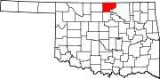
Washington County is a county located in the northeastern part of the U.S. state of Oklahoma. As of the 2020 census, the population was 52,455. Its county seat is Bartlesville. Named for President George Washington, it is the second smallest county in Oklahoma in total area, adjacent to the largest county in Oklahoma, Osage County.

<span class="mw-page-title-main">LeFlore County, Oklahoma</span> County in Oklahoma, United States

LeFlore County is a county along the eastern border of the U.S state of Oklahoma. As of the 2020 census, the population was 48,129. Its county seat is Poteau. The county is part of the Fort Smith metropolitan area and the name honors a Choctaw family named LeFlore. The United States District Court for the Eastern District of Oklahoma is the federal district court with jurisdiction in LeFlore County.

<span class="mw-page-title-main">Kay County, Oklahoma</span> County in Oklahoma, United States

Kay County is a county located in the U.S. state of Oklahoma. As of the 2020 census, its population was 43,700. Its county seat is Newkirk, and the largest city is Ponca City.

<span class="mw-page-title-main">Delaware County, Oklahoma</span> County in Oklahoma, United States

Delaware County is a county located in the U.S. state of Oklahoma. As of the 2020 census, the population was 40,397. Its county seat is Jay. The county was named for the Delaware Indians, who had established a village in the area prior to the Cherokees being assigned to relocate to Indian Territory in the 1830s. Delaware County was created in 1907. Prior to becoming Delaware County, a large portion of the area was known as the Delaware District of the Cherokee Nation. Today, Delaware County continues to be recognized by the Cherokee Nation as the Delaware District.

<span class="mw-page-title-main">Sevier County, Arkansas</span> County in Arkansas, United States

Sevier County is a county located in the U.S. state of Arkansas. As of the 2020 census, the population was 15,839. The county seat is De Queen. Sevier County is Arkansas's 16th county, formed on October 17, 1828, and named for Ambrose Sevier, U.S. Senator from Arkansas. On November 3, 2020, voters in Sevier County, AR approved alcohol sales by a vote of 3,499 to 1,699.

<span class="mw-page-title-main">Little River County, Arkansas</span> County in Arkansas, United States

Little River County is a county located on the southwest border of the U.S. state of Arkansas, bordering a corner with Texas and Oklahoma. As of the 2020 census, the population was 12,026. The county seat is Ashdown.

<span class="mw-page-title-main">Lake City, Arkansas</span> City in Arkansas, United States

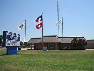
Lake City is a city in Craighead County, Arkansas, United States, along the St. Francis River. Lake City is one of two county seats in Craighead County. The population was 2,326 as of the 2020 census. It is included in the Jonesboro, Arkansas Metropolitan Statistical Area.

<span class="mw-page-title-main">West Siloam Springs, Oklahoma</span> Town in Oklahoma, United States

West Siloam Springs is a town in Delaware County, Oklahoma, United States. The population was 1,000 at the 2020 census, an 18.2 percent increase from the figure of 846 recorded in 2010. A bedroom community for Siloam Springs, Arkansas, it is notable for its Cherokee casino, and is the closest town to Natural Falls State Park.

<span class="mw-page-title-main">Pauls Valley, Oklahoma</span> City in Oklahoma, United States

Pauls Valley is a city in and the county seat of Garvin County, Oklahoma, United States. The population was 5,992 at the 2020 census, a decline of 3.2 percent from the figure of 6,187 in 2010. It was settled by and named for Smith Paul, a North Carolina native who married a Chickasaw woman and became a citizen of the Chickasaw Nation before the Civil War. The town economy is largely based on agriculture and oil production.

<span class="mw-page-title-main">Newkirk, Oklahoma</span> City in Oklahoma, United States

Newkirk is a city and county seat of Kay County, Oklahoma, United States. The population was 2,172 at the 2020 census.

<span class="mw-page-title-main">Tonkawa, Oklahoma</span> City in Oklahoma, United States

Tonkawa is a city in Kay County, Oklahoma, United States, along the Salt Fork Arkansas River. The population was 3,015 as of the 2020 United States census.

<span class="mw-page-title-main">Hobart, Oklahoma</span> City in Oklahoma, United States

Hobart is a city in, and the county seat of, Kiowa County, Oklahoma, United States. It is west-southwest of Oklahoma City, and northwest of Lawton. It was named for Garret Hobart, the 24th Vice President of the United States. The population was 3,413 at the 2020 Census. It is served by Hobart Regional Airport. It also has two museums: the General Tommy Franks Museum and the Kiowa County Museum.

<span class="mw-page-title-main">Thackerville, Oklahoma</span> Town in Oklahoma, United States

Thackerville is a town in Love County, Oklahoma, United States. It is located near the Texas state border. The population was 400 at the 2020 census.

<span class="mw-page-title-main">Lenapah, Oklahoma</span> Town in Oklahoma, United States

Lenapah is a town in north central Nowata County, Oklahoma, United States, eleven miles north of Nowata and sixty two miles northeast of Tulsa. Its name is an adaptation of Lenape, the name of a Delaware Tribe of Indians. The population was 293 at the 2010 census, a 1.7 percent decrease from the figure of 298 recorded in 2000.

<span class="mw-page-title-main">Lake Aluma, Oklahoma</span> Town in Oklahoma, United States

Lake Aluma is a town in Oklahoma County, Oklahoma, United States, and a part of the Oklahoma City Metropolitan Area. The population was 88 at the 2010 census.

<span class="mw-page-title-main">Cleveland, Oklahoma</span> City in Oklahoma, United States

Cleveland is a city in Pawnee County, Oklahoma, United States. The 2010 census population was 3,251, a decrease of 0.9 percent from the figure of 3,282 recorded in 2000.

<span class="mw-page-title-main">Pawnee, Oklahoma</span> City in Oklahoma, United States

Pawnee is a city and county seat of Pawnee County, Oklahoma, United States. The town is northeast of Stillwater at the junction of U.S. Route 64 and State Highway 18.

<span class="mw-page-title-main">Ralston, Oklahoma</span> Town in Oklahoma, United States

Ralston is a town in Pawnee County, Oklahoma, United States. The town is southeast of Ponca City on State Highway 18 near the west bank of the Arkansas River. The population was 330 at the 2010 census, a decline of 7 percent from the figure of 355 recorded in 2000.

<span class="mw-page-title-main">Muldrow, Oklahoma</span> Town in Oklahoma, United States

Muldrow, officially the Town of Muldrow, is a town in Sequoyah County, Oklahoma, United States. It is part of the Fort Smith, Arkansas–Oklahoma Metropolitan Statistical Area. The population was 3,466 at the 2010 census, an increase of 11.7 percent over the figure of 3,104 recorded in 2000.

<span class="mw-page-title-main">Davis, Oklahoma</span> City in Oklahoma, United States

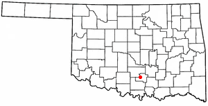
Davis is a city in Garvin and Murray counties in the U.S. state of Oklahoma. The population is 2,823 as of the 2020 census.

References

  1. 1 2 3 U.S. Geological Survey Geographic Names Information System: Kaw City, Oklahoma
  2. "ArcGIS REST Services Directory". United States Census Bureau. Retrieved September 20, 2022.
  3. 1 2 "U.S. Census website". United States Census Bureau . Retrieved January 31, 2008.
  4. "Kaw City (city), Oklahoma". U.S. Census Bureau. Retrieved March 21, 2024.
  5. 1 2 3 Pittman, Annette. Encyclopedia of Oklahoma History and Culture. "Kaw City."
  6. 1 2 The Oklahoman. "When Kaw Cityans Moved Town, 70 Years of Proud History Moved, Too" by Burnis Argo. August 7, 1983
  7. Kaw City, OK, 7.5 Minute Topographic Quadrangle, USGS, 1964 (1979 rev.)
  8. "US Gazetteer files: 2010, 2000, and 1990". United States Census Bureau. February 12, 2011. Retrieved April 23, 2011.
  9. "Census of Population and Housing". Census.gov. Retrieved June 4, 2018.
  10. "Kaw City Museum". TravelOK.com. Retrieved July 18, 2020.
  11. "Kanza Museum". TravelOK.com. Retrieved July 18, 2020.
  12. 1 2 "Kaw City". KawLake.com. Retrieved July 18, 2020.
  13. "2020 CENSUS - SCHOOL DISTRICT REFERENCE MAP: Kay County, OK" (PDF). U.S. Census Bureau. p. 2 (PDF p. 3/3). Retrieved January 26, 2024. - Text list