
The Lewis and Clark Expedition, also known as the Corps of Discovery Expedition, was the United States expedition to cross the newly acquired western portion of the country after the Louisiana Purchase. The Corps of Discovery was a select group of U.S. Army and civilian volunteers under the command of Captain Meriwether Lewis and his close friend Second Lieutenant William Clark. Clark and 30 members set out from Camp Dubois, Illinois, on May 14, 1804, met Lewis and ten other members of the group in St. Charles, Missouri, then went up the Missouri River. The expedition crossed the Continental Divide of the Americas near the Lemhi Pass, eventually coming to the Columbia River, and the Pacific Ocean in 1805. The return voyage began on March 23, 1806, at Fort Clatsop, Oregon, and ended on September 23 of the same year.

The Missouri River is the longest river in the United States. Rising in the Rocky Mountains of the Eastern Centennial Mountains of Southwestern Montana, the Missouri flows east and south for 2,341 miles (3,767 km) before entering the Mississippi River north of St. Louis, Missouri. The river drains a sparsely populated, semi-arid watershed of more than 500,000 square miles (1,300,000 km2), which includes parts of ten U.S. states and two Canadian provinces. Although a tributary of the Mississippi, the Missouri River is slightly longer and carries a comparable volume of water. When combined with the lower Mississippi River, it forms the world's fourth longest river system.

The Kansas River, also known as the Kaw, is a river in northeastern Kansas in the United States. It is the southwesternmost part of the Missouri River drainage, which is in turn the northwesternmost portion of the extensive Mississippi River drainage. Its two names both come from the Kanza (Kaw) people who once inhabited the area; Kansas was one of the anglicizations of the French transcription Cansez of the original kką:ze. The city of Kansas City, Missouri, was named for the river, as was later the state of Kansas.

The Platte Purchase was a land acquisition in 1836 by the United States government from American Indian tribes of the region. It comprised lands along the east bank of the Missouri River and added 3,149 square miles (8,156 km2) to the northwest corner of the state of Missouri.
This is the timeline of the Lewis and Clark Expedition through the American West, 1803-1806.

The Santa Fe Trail was a 19th-century route through central North America that connected Franklin, Missouri, with Santa Fe, New Mexico. Pioneered in 1821 by William Becknell, who departed from the Boonslick region along the Missouri River, the trail served as a vital commercial highway until 1880, when the railroad arrived in Santa Fe. Santa Fe was near the end of El Camino Real de Tierra Adentro which carried trade from Mexico City. The trail was later incorporated into parts of the National Old Trails Road and U.S. Route 66.
Edward "Ted" and Pat Jones-Confluence Point State Park is a public recreation area located on the north side of the Missouri River at its confluence with the Mississippi River in St. Charles County, Missouri. The state park encompasses 1,121 acres (454 ha) of shoreline and bottomland and is managed by the Missouri Department of Natural Resources, which "plans to restore a natural floodplain reminiscent of what Lewis and Clark might have seen along the lower Missouri River." The park is part of the Mississippi Greenway and sits opposite the Columbia Bottom Conservation Area on the south bank of the Missouri River. Park trails will eventually connect with the statewide Katy Trail.

The Lewis and Clark National Historic Trail is a route across the United States commemorating the Lewis and Clark Expedition of 1804 to 1806. It is part of the National Trails System of the United States. It extends for some 4,900 miles (7,900 km) from Pittsburgh, Pennsylvania, to the mouth of the Columbia River in Oregon.

Lewis and Clark Lake is a 31,400 acre (130 km²) reservoir located on the border of the U.S. states of Nebraska and South Dakota on the Missouri River. The lake is approximately 25 miles (40 km) in length with over 90 miles (140 km) of shoreline and a maximum water depth of 45 feet (14 m). The lake is impounded by Gavins Point Dam and is managed by the U.S. Army Corps of Engineers, Omaha District.
The Missouri National Recreational River is a National Recreational River located on the border between Nebraska and South Dakota. The designation was first applied in 1978 to a 59-mile section of the Missouri River between Gavins Point Dam and Ponca State Park. In 1991, an additional 39-mile section between Fort Randall Dam and Niobrara, Nebraska, was added to the designation. These two stretches of the Missouri River are the only parts of the river between Montana and the mouth of the Missouri that remain undammed or unchannelized. The last 20 miles of the Niobrara River and 6 miles of Verdigre Creek were also added in 1991.

Fort Osage was an early 19th-century factory trading post run by the United States Government in western Missouri on the American frontier; it was located in present-day Sibley, Missouri. The Treaty of Fort Clark, signed with certain members of the Osage Nation in 1808, called for the United States to establish Fort Osage as a trading post and to protect the Osage from tribal enemies.

The West Bottoms is a historic industrial neighborhood of Kansas City, Missouri, immediately west of downtown and straddling the border of Kansas City, Missouri and Kansas City, Kansas. At the confluence of the Missouri River and the Kansas River, it faces Kaw Point, an early campsite of the Lewis and Clark Expedition. The region was originally settled by the native tribes, and this spot was permanently settled as French Bottoms in the early 1800s by François Chouteau for his trade with the tribes and early American pioneers. It is one of the oldest areas of the metro along with Westport. Its neighboring Quality Hill neighborhood is a historical center of the pioneer Town of Kansas, which became Kansas City, Missouri.

Fort Orleans was a French fort in colonial North America, the first fort built by any European forces on the Missouri River. It was built near the mouth of the Grand River near present-day Brunswick. Intended to be the linchpin in the vast New France empire stretching from Montreal to New Mexico, the fort was occupied from 1723–1726. It was the first multi-year European settlement in what is today the U.S. state of Missouri.

Missouri Headwaters State Park is a public recreation area occupying 535 acres (217 ha) at the site of the official start of the Missouri River. The park offers camping, hiking trails, hunting, and water-related activities. It is located on Trident Road northeast of Three Forks, Montana at an elevation of 4,045 feet (1,233 m). The park includes the Three Forks of the Missouri National Historic Landmark, designated in 1960 because the site is one where the Lewis and Clark Expedition camped in 1805.
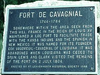
Fort de Cavagnial was a French fort and trading post located on the west cliffs of the Missouri River, somewhere north of Kansas City, Kansas, and Fort Leavenworth, Kansas, from 1744 until about 1764. While the ruins of the site were still visible when Meriwether Lewis and William Clark ventured in the area during their famed 1804 westward expedition, all traces of the fort were eventually lost by the mid-19th century. Today, the exact location of the fort is a mystery.

Sacagawea was a Lemhi Shoshone woman who, in her teens, helped the Lewis and Clark Expedition in achieving their chartered mission objectives by exploring the Louisiana Territory. Sacagawea traveled with the expedition thousands of miles from North Dakota to the Pacific Ocean, helping to establish cultural contacts with Native American people and contributing to the expedition's knowledge of natural history in different regions.

Old Baldy, also known as the Tower, is a hill located near the village of Lynch, in Boyd County, in the northern part of the state of Nebraska in the Midwestern United States. It was visited by the Lewis and Clark Expedition on their way up the Missouri River in 1804; nearby, they discovered a colony of prairie dogs, an animal previously unknown to scientists.

Calumet Bluff is a hill about 180 feet high overlooking Lewis and Clark Lake and the Missouri River in Cedar County, Nebraska, U.S., where the Lewis and Clark Expedition held its first council with the Sioux Indians for two days in 1804. Today the Bluff forms the right or south abutment of the Gavins Point Dam. The U.S. Army Corps of Engineers maintains the Lewis and Clark Visitor Center and the Gavins Point Project Administration Offices on Calumet Bluff overlooking the dam.

Tower Rock State Park is a state park near the community of Cascade in the U.S. state of Montana in the United States. The centerpiece of the park is Tower Rock, a 424-foot (129 m)-high rock formation which marks the entrance to the Missouri River Canyon in the Adel Mountains Volcanic Field. It was well known to Native Americans, and considered a sacred place by the Piegan Blackfeet. Tower Rock received its current name when Meriwether Lewis of the Lewis and Clark Expedition visited the site in 1805. Railroad and highway development in the late 1800s and 1900s skirted Tower Rock, but the landform itself remained pristine. The 87.2 acres (0.353 km2) encompassing Tower Rock was added to the National Register of Historic Places on March 18, 2002. The 140-acre (0.57 km2) Tower Rock State Park was created around the National Historic Site in 2004.

