
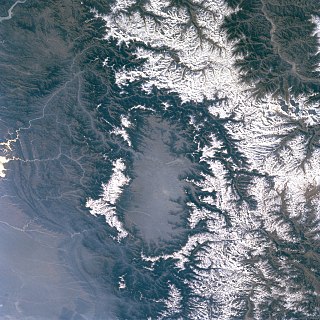
Kashmir is the northernmost geographical region of the Indian subcontinent. Until the mid-19th century, the term "Kashmir" denoted only the Kashmir Valley between the Great Himalayas and the Pir Panjal Range. Today, the term encompasses a larger area that includes the India-administered territories of Jammu and Kashmir and Ladakh, the Pakistan-administered territories of Azad Kashmir and Gilgit-Baltistan, and the Chinese-administered territories of Aksai Chin and the Trans-Karakoram Tract.
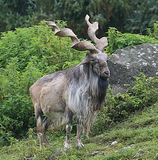
The markhor is a large wild Capra (goat) species native to South Asia and Central Asia, mainly within Pakistan, India, the Karakoram range, parts of Afghanistan, and the Himalayas. It is listed on the IUCN Red List as Near Threatened since 2015.

Northern Pakistan is a tourism region in northern and north-western parts of Pakistan, comprising the administrative units of Gilgit-Baltistan, Azad Kashmir, Khyber Pakhtunkhwa, Islamabad Capital Territory and the Rawalpindi Division in Punjab. The first two territories are a part of the wider Kashmir region. It is a mountainous region straddling the Himalayas, Karakoram and the Hindu Kush mountain ranges, containing many of the highest peaks in the world and some of the longest glaciers outside polar regions. Northern Pakistan accounts for a high level of Pakistan's tourism industry.
The Kashmir Valley, also known as the Vale of Kashmir, is an intermontane valley in northern Jammu and Kashmir, a region in Indian-administered Kashmir. The valley is surrounded by ranges of the Himalayas, bounded on the southwest by the Pir Panjal Range and on the northeast by the Greater Himalayan range. It is approximately 135 km (84 mi) long and 32 km (20 mi) wide, and drained by the Jhelum River. It forms the bulk of the Kashmir Division of Jammu and Kashmir.

The Himalayan monal, also called Impeyan monal and Impeyan pheasant, is a pheasant native to Himalayan forests and shrublands at elevations of 2,100–4,500 m (6,900–14,800 ft). It is part of the family Phasianidae and is listed as Least Concern on the IUCN Red List. It is the national bird of Nepal, where it is known as the danphe or danfe, and state bird of Uttarakhand, India, where it is known as a monal. The scientific name commemorates Lady Mary Impey, the wife of the British chief justice of Bengal, Sir Elijah Impey.

Dachigam National Park is a national park located, 22 kilometres (14 mi) from Srinagar city in Srinagar district of in the Indian-administered Kashmir on the east side of Dal Lake. It covers an area of about 141 square kilometres (54 sq mi). The name of the park literally stands for "ten villages" which is in the memory of the ten villages that were relocated for its formation. These ten villages were living in this region before the World War I in the beginning of 20th century. The main gate entrance is very close to the New Theed general bus stand on the either side of Darul Uloom Kousaria.

Ladakh is the home to endemic Himalayan wildlife, such as the bharal, yak, Himalayan brown bear, Himalayan wolf and the iconic snow leopard. Hemis National Park, Changthang Cold Desert Wildlife Sanctuary, and Karakorum Wildlife Sanctuary are protected wildlife areas of Ladakh. The Mountain Institute, the Ladakh Ecological Development Group and the Snow Leopard Conservancy work on ecotourism in rural Ladakh. For such an elevated, arid area, Ladakh has great diversity of birds — 318 species have been recorded. Many of these birds reside at or seasonally breed in high-altitude wetlands, such as Tso Moriri, or near rivers and water sources.
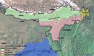
The Eastern Himalayas extend from eastern Nepal across Northeast India, Bhutan, the Tibet Autonomous Region to Yunnan in China and northern Myanmar. The climate of this region is influenced by the monsoon of South Asia from June to September. It is a biodiversity hotspot, with notable biocultural diversity.

Chitral Gol National Park is one of the National Parks of Pakistan. It is located in Lower Chitral District in Khyber-Pakhtunkhwa province of Pakistan beside the Chitral River, at a distance of two hours drive from Chitral town. The park is also known as Chitral National Park.

The wildlife of Pakistan comprises a diverse flora and fauna in a wide range of habitats from sea level to high elevation areas in the mountains, including 195 mammal, 668 bird species and more than 5000 species of Invertebrates. This diverse composition of the country's fauna is associated with its location in the transitional zone between two major zoogeographical regions, the Palearctic, and the Oriental. The northern regions of Pakistan, which include Khyber Pakhtunkhwa and Gilgit Baltistan include portions of two biodiversity hotspot, Mountains of Central Asia and Himalayas.
The Astor markhor or flare-horned markhor is a subspecies of the markhor, native to Kashmir and northern Pakistan. To the west it reaches the easternmost parts of Afghanistan. The range of the Astor markhor is very scattered. At one time considered an "endangered species", conservation efforts have had some success and the largest subpopulation in Pakistan may now exceed 1000 individuals. As a result, the International Union for Conservation of Nature has rated its status as "near-threatened".
Pakistan's native fauna reflect its varied climatic zones. The northern Pakistan, which includes Khyber Pakhtunkhwa and Gilgit Baltistan, has portions of two biodiversity hotspots, Mountains of Central Asia and Himalayas.

The Western Himalayan broadleaf forests is a temperate broadleaf and mixed forest ecoregion which is found in the middle elevations of the western Himalayas, including parts of Nepal, India, and Pakistan.

The Northwestern Himalayan alpine shrub and meadows is a montane grasslands and shrublands ecoregion of the elevations of the northwestern Himalaya of China, India, and Pakistan.

The Western Himalayan subalpine conifer forests is a temperate coniferous forests ecoregion of the middle and upper elevations of the western Middle Himalayas of Nepal, India, and Pakistan.
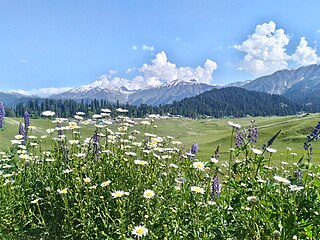
The ecology of the Himalayas varies with climate, rainfall, altitude, and soils. The climate ranges from tropical at the base of the mountains to permanent ice and snow at the highest elevations. The amount of yearly rainfall increases from west to east along the southern front of the range. This diversity of climate, altitude, rainfall and soil conditions supports a variety of distinct plant and animal species, such as the Nepal gray langur

Hirpora Wildlife Sanctuary or Heerpora Wildlife Sanctuary is located, Hirpora in Shopian district of Jammu and Kashmir. It lies 12 km from Shopian town, 70 km (43 mi) south of Srinagar. It spreads over an area of 341 km2 (132 sq mi). It is bounded to the north by Lake Gumsar, northeast by Hirpora village, east by Rupri, south by Saransar and to the west by the Pir Panjal pass. The slopes are gentle to moderately steep on the eastern aspect and very steep with many cliffs on the higher northern and western aspect. The southern and southeastern portions are moderately steep. Heerpora wildlife sanctuary is one of the beautiful wildlife sanctuary in Jammu and Kashmir
Kazinag Peak is a mountain with peak elevation of 4,574 metres (15,007 ft) meters from sea level, located in the uri to Dangiwacha of district baramulla to kupwara, Jammu and Kashmir in India. It forms part of the Line of Control between Pakistan and India.
The Gulmarg Wildlife Sanctuary spread over 180 square kilometres (69 sq mi) is a protected area in Gulmarg, Baramulla district of Jammu and Kashmir, India. The sanctuary lies on the north-eastern side of the Pir Panjal mountain range and falls under the northwest Biogeographic Zone 2A. It lies 50 kilometres (31 mi) south-west of Srinagar and 26 kilometres (16 mi) from Baramulla. The sanctuary was first declared as a game reserve in 1981 and later upgraded to a sanctuary in 1987.
Limber Wildlife Sanctuary or Kazing Wildlife Sanctuary is situated in Jammu & Kashmir. It is the fourth national park in the state which focuses the attention towards conserving the rare markhor wild goat. It is also a part of an eco-sensitive zone as notified by the Government of Jammu & Kashmir.