Keeill

Last updated

Keeill (also keill, keeil; plural kialteenyn or keeills) is a specific type of small simple chapel found on the Isle of Man and built between the 6th and 12th centuries. [1]

Contents

Etymology

The word is a borrowing from Manx Gaelic where it means 'chapel'. The term is ultimately from the Latin cella, which originally meant a storeroom, or a small room. In both English, and the Goidelic languages, the word was borrowed in the sense of a monastic cell.

History and siting

Some similar sites have been identified on Islay [2] and Gallarus Oratory. [3]

The earliest versions of the structures are all thought to have been lost, and only their later replacements (mostly in use between the 8th and 12th centuries) survive. These survivors vary in size and arrangement, and include examples constructed in unhewn or roughly worked stones, stone-revetted turf and timber-laced rubble. Beneath some sites remnants of clay daub have been found (Megaw 1978:298), while traces of wall plaster have also been discovered. Keeills may have fallen out of use following the arrival of Viking settlers on the Island, but were then re-established, on the same sites in some cases, once the Vikings had converted to Christianity.

A number of keeills were built on a natural or artificial mound, often the site of earlier burials or monuments (e.g. Bronze-Age barrow mounds) (Lowe and Reilly 1988) and/or near a spring or holy well (a chibbyr). Many keeills are surrounded by cemeteries, some of which may have originated in pagan society. Some keeills are enclosed by a turf bank. The area of ground bounded by such a bank can vary considerably and may represent earlier, pre-Christian use.

Number

At least 174 keeills have been recorded on the Island, out of probably over 200, though only 35 can be easily identified today. Records are made up of extant sites, potential remains, place-name records and folk memory. The nature of some of this evidence is sufficient to cast doubt on the reliability of the total record. Most of the sites have either been lost (e.g. when a later medieval church such as Kirk Maughold or Kirk Christ Malew was built on top of or in place of one), or destroyed when excavated by Victorian and Edwardian antiquarians looking for ground plans and treasure rather than stratigraphy and finds.

Size, layout and comparisons

Keeill in Maughold churchyard. One of three Keeills in this churchyard. Keeill in Maughold churchyard.jpg
Keeill in Maughold churchyard. One of three Keeills in this churchyard.

While different keeills were broadly similar in their layout they varied considerably in size.

Carl J. S. Marstrander, a Norwegian professor who carried out what remains the most extensive survey of keeills on the Isle of Man in the 1930s, described this variation:

The Ballachrink keeill in Marown measures only 10 feet × 6 feet inside. Otherwise they may attain 23 feet × 13 feet (Keeill Vian, Lonan), even 57 feet × 18 feet (St Patrick's Chapel, Patrick's Isle), and 75 feet × 24 feet (St. Trinian's, Marown). The walls vary in thickness from 2 feet 4 inches to 4 feet 8 inches and are, on the outside, protected by an embankment of earth and stones, in height 2-5 feet, in depth 4-10 feet.

Marstrander's inclusion of the notably larger structures he mentions here is now deprecated, in view of their later date.

...The shape is rectangular with no division between nave and chancel. The door, which is narrow and tapering towards the top, is usually situated in the western gable. The window – as a rule only one – is built at a height of 2-3 feet above the floor. The altar is invariably placed against the eastern wall, attaining a height of about 2 feet.

Detailed work drawing comparisons with sites in the Northern Isles has been undertaken by Lowe (1987), and with those on Islay, by Swift (1987).

Time Team

The keeill excavated in 2007 by Time Team fitted into Marstrander's general pattern, in terms of walls, rectangular shape, lack of identifiable internal divisions, and having a single narrow entrance and an eastern altar.[ citation needed ]

See also

Related Research Articles

<span class="mw-page-title-main">St Michael's Isle</span> Island of the Isle of Man

St Michael's Isle, more commonly referred to as Fort Island, is an island in Malew parish in the Isle of Man, noted for its attractive ruins. It covers an area of 5.14 hectares, is about 400 metres long from west to east, and is connected to the Langness Peninsula, near Derbyhaven, by a narrow causeway. The island itself is made of rocky slate and the soil is very acidic. Nevertheless, it has important communities of maritime plants.

<span class="mw-page-title-main">Port St Mary</span> Human settlement on the Isle of Man

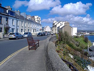
Port St Mary is a village district in the south-west of the Isle of Man. The village takes its name from the former Chapel of St Mary which is thought to have overlooked Chapel Bay in the village. Its population is 1,953 according to the 2011 census. In the 19th century it was sometimes called Port-le-Murray.

<span class="mw-page-title-main">Buggane</span> Isle of Mann folklore figure

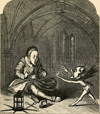
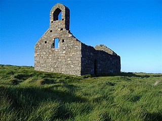
In Manx folklore, a buggane was a huge ogre-like creature native to the Isle of Man. Some have considered them akin to the Scandinavian troll.

Gerhard Bersu was a German archaeologist who excavated widely across Europe. He was forced into exile from Germany in 1937 due to anti-Semitic laws in pre-war Nazi Germany. He was interned on the Isle of Man during World War II where he made several significant archaeological discoveries such as the Viking boat burial at Balladoole.

<span class="mw-page-title-main">Ballabeg</span> Village in the Isle of Man

Ballabeg is a village on the Isle of Man. It is in the parish of Arbory in the sheading of Rushen, in the south of the island near Castletown. There are several small villages and hamlets with the name, although Ballabeg in Arbory is the most well-known and populous.

<span class="mw-page-title-main">Manx literature</span> Literature in the Manx language

Literature in the Manx language is known from the 16th century. Early works were often religious in theme, including translations of the Book of Common Prayer, the Bible and Milton's Paradise Lost. Edward Faragher, who published poems, stories and translations, is considered the last major native writer of the language. The historian A. W. Moore collected traditional Manx-language songs and ballads in publications towards the end of the 19th century.

<span class="mw-page-title-main">Andreas (parish)</span> Parish on the Isle of Man

Andreas is one of the seventeen parishes of the Isle of Man. It is located in the north of the island in the sheading of Ayre. The main settlement in the parish in the village of Andreas, which is also known as Kirk Andreas.

<span class="mw-page-title-main">Mount Murray</span> Hill on the Isle of Man

Mount Murray is a hill 222 metres (728 ft) above sea level on the Isle of Man located at the northern end of Santon, near the boundaries with Marown and Braddan parishes. It is named after Lord Henry Murray, 4th Lieutenant Governor of the Isle of Man. Often referred to simply as The Mount and formerly as Cronk Glass(green hill), Mount Murray is home to the Chibbanagh Plantation and nine of the eighteen holes of the Mount Murray Golf Club.

<span class="mw-page-title-main">Andreas, Isle of Man</span> Village on the Isle of Man

Andreas or Kirk Andreas is a village on the Isle of Man, lying in the north of the island, 5 km from the island's second town, Ramsey. There is a large, and nowadays little used, airfield in the vicinity.

Crosby is a small village located 3+34 miles west of Douglas in the parish of Marown in the Isle of Man.

<span class="mw-page-title-main">Greeba Castle</span>

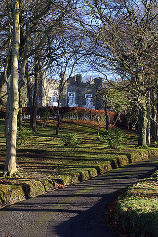
Greeba Castle is a castle on the Isle of Man.

<span class="mw-page-title-main">Highlander, Isle of Man</span>

Highlander is situated between the 5th and 6th Milestone road-side markers on the Snaefell Mountain Course used for the Isle of Man TT races on the primary A1 Douglas to Peel road in the parish of Marown in the Isle of Man.

<span class="mw-page-title-main">Ballabeg, Lonan</span> Human settlement in the United Kingdom

There are about eight small places on the Isle of Man with the name Ballabeg. The name Ballabeg derives from the Manx Balley Beg which means small homestead; although the spelling is different, it is pronounced approximately the same as the English name.

<span class="mw-page-title-main">Ballagarey Corner, Isle of Man</span> Residential village and point on road-race course

Ballagarey is located between the third and fourth milemarkers used for recognition of the Snaefell Mountain Course road-racing circuit on the primary A1 Douglas to Peel road, in the parish of Marown in the Isle of Man.

The Ronaldsway Culture was the way of life of a Stone Age people on the Isle of Man. Sometimes referred to as Manx Ronaldsway, it dates from the later Neolithic and from the third millennium BC, but more precise dating is a matter of debate.

<span class="mw-page-title-main">Old St Runius, Marown</span> Church in Isle of Man

St Runius, Marown dates to the 12th century and was the parish church of Marown until 1853. Today it only holds services for special occasions.

<span class="mw-page-title-main">William Cubbon</span> Manx nationalist, antiquarian, author, businessman and librarian

William Cubbon M.A. was a Manx nationalist, antiquarian, author, businessman and librarian who was the first secretary of the Manx Museum, later becoming Director of the Museum.

<span class="mw-page-title-main">St Trinian's Church</span> Church in Isle of Man, Isle of Man

St Trinian's Church is the roofless ruin of a small chapel at the foot of Greeba Mountain, adjacent to the main A1 Douglas - Peel Road in the parish of Marown, Isle of Man. Referred to in the Manx language as a "Keeil Brisht", the church is the source of an ancient Manx folktale concerning the Buggane, a huge mythical ogre who lived on Greeba Mountain and who vowed that the church should never be completed.

<span class="mw-page-title-main">Balladoole</span> Historic monument site on the Isle of Man

Chapel Hill, Balladoole is a significant historical and archaeological site in Arbory on the Isle of Man. The site is a short distance from Castletown in the south of the Island. It is located on a small hilltop overlooking the coast. Balladoole has undergone extensive archaeological excavations in the 20th century, most notably in 1944-1945 by German archaeologist Gerhard Bersu who was interned on the Isle of Man during World War II.

<span class="mw-page-title-main">Knock y Doonee</span> Historic monument site on the Isle of Man

Knock y Doonee is a significant historical and archaeological site in the parish of Andreas on the northern coast of the Isle of Man. The site has been in ritual use for centuries. Archaeological excavations have uncovered a Christian keeill with a bilingual ogham stone and a Christian carved stone cross; and on a nearby hilltop a Viking Age boat burial.

References

Notes
  1. Speke Keeill, Mount Murray Hotel, Isle of Man: Archaeological Evaluation and Assessment of Results (PDF). Wessex Archaeology. 2007. Archived from the original (PDF) on 5 March 2016. Retrieved 1 January 2016.
  2. Megaw 1978:298; Swift 1987
  3. Artymiuk, Simon (8 January 2015). "Antiquarians' (sic) lecture on reassessing keeills". Isle of Man Newspapers . Archived from the original on 12 January 2015. Retrieved 1 January 2016.