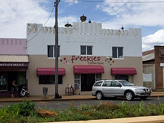
Coonabarabran is a town in Warrumbungle Shire that sits on the divide between the Central West and North West Slopes regions of New South Wales, Australia. At the 2016 census, the town had a population of 2,537. The town's nickname is "Coona".

Lindfield is a suburb on the Upper North Shore of Sydney in the state of New South Wales, Australia. It is 13 kilometres north-west of the Sydney Central Business District and is in the local government area of Ku-ring-gai Council. East Lindfield is a separate suburb, although they share the postcode of 2070.

Glen Innes is a parish and town on the Northern Tablelands, in the New England region of New South Wales, Australia. It is the centre of the Glen Innes Severn Shire Council. The town is located at the intersection of the New England Highway and the Gwydir Highway. At the 2016 census, Glen Innes had a population of 6,155.

Hillston is a township in western New South Wales, Australia, in Carrathool Shire, on the banks of the Lachlan River. It was founded in 1863 and at the 2016 census had a population of 1,465.

Berowra is an outer suburb of Northern Sydney located in the state of New South Wales, Australia 38 kilometres north of the Sydney central business district, in the local government area of Hornsby Shire. Berowra is south-east of the suburbs of Berowra Heights and east of Berowra Waters. The name Berowra means place of many shells, referring to the many shell middens on Berowra Creek.

Emu Plains is a suburb of Sydney in the state of New South Wales, Australia. It is 58 kilometres west of the Sydney central business district, in the local government area of the City of Penrith and is part of the Greater Western Sydney region.

Mount Victoria is a small township in the Blue Mountains of New South Wales, Australia. It is the westernmost village in the City of Blue Mountains, located about 120 kilometres (75 mi) by road from the Sydney central business district and at an altitude of about 1,052 metres (3,451 ft) AHD . The settlement had a population of 823 people at the 2011 Census.

Bellata is a small village in north-central New South Wales, Australia, in Narrabri Shire. At the 2006 census, Bellata had a population of 529. The place name Bellata could be derived from the local Aboriginal word meaning "kangaroo" or possibly "home of belar trees".

Ben Lomond is a village on the Northern Tablelands in the New England region of New South Wales, Australia. The village is situated 6 km off the New England Highway between Armidale and Glen Innes. It was located in the Guyra Shire local government area until that council was amalgamated into the Armidale Regional Council on 12 May 2016, with parts of the surrounding district in Glen Innes Severn Shire and Inverell Shire. It is primarily a farming area, with most of the residents involved in sheep, cattle and grain farming.

Murrumburrah is a township in New South Wales, Australia, part of a twin town with Harden. The town is in Hilltops Council local government area in the South West Slopes area of NSW. It is on the Burley Griffin Way, the major link from the Riverina to the Hume Highway near Yass, and ultimately Sydney, Canberra and the coast. At the 2011 census, Murrumburrah had a population of 479.

Kamarah, is a village community in the central north part of the Riverina. It is situated by road, about 11 kilometres west of Ardlethan and 12 kilometres east of Moombooldool. At the 2006 census, Kamarah had a population of 130 people.

Springdale is a village community in the central north part of the Riverina region of the Australian state of New South Wales. It is situated by road, about 3 kilometres east of Combaning and 23 kilometres north west of Stockinbingal. At the 2016 census, it had a population of 150.

Milbrulong is a locality in the central east part of the Riverina region of New South Wales, Australia. The locality is 515 kilometres (320 mi) south west of the state capital, Sydney and 59 kilometres (37 mi) south west of the regional centre Wagga Wagga in the Lockhart Shire local government area. The standard gauge Oaklands railway line passes through the locality.

Peranga is a town and a locality in the Toowoomba Region, Queensland, Australia.

Wallabadah is a town in the New England region of New South Wales, Australia. The town is located 55 kilometres south of Tamworth on the New England Highway and is in the Liverpool Plains Shire. At the 2006 census, Wallabadah had a population of 746.

Dorrigo, a small town on the Waterfall Way, is located on the Northern Tablelands, in northern New South Wales, Australia. The town is part of Bellingen local government area.

Baradine is a small town in north western New South Wales, Australia. At the 2006 census, Baradine had a population of 593.

Wollun is a small rural community about 26 kilometres north-west of Walcha and is included in the Uralla Shire local government area of the Northern Tablelands region of New South Wales, Australia.

Ardglen is a village on the Main North railway line and close to the New England Highway on the North West Slopes region of New South Wales, Australia.

Georges Plains is a locality in the Bathurst Region of New South Wales, Australia. It had a population of 248 people as of the 2016 census.


