Kempraten

Last updated
Kempraten
Zurichsee - Kempraten - Bachtel IMG 1140.JPG
Location of Kempraten
Kempraten
Switzerland adm location map.svg
Red pog.svg
Kempraten
Reliefkarte St. Gallen blank.png
Red pog.svg
Kempraten
Coordinates: 47°14′N8°49′E / 47.233°N 8.817°E / 47.233; 8.817
Country Switzerland
Canton St. Gallen
District See-Gaster
Municipality Rapperswil-Jona
Elevation
409 m (1,342 ft)
Time zone UTC+01:00 (Central European Time)
  Summer (DST) UTC+02:00 (Central European Summer Time)
Postal code(s)
8640
Surrounded by Bubikon (ZH), Hombrechtikon (ZH), Jona, Rapperswil, Rüti (ZH)
Website www.rapperswil-jona.ch

Kempraten-Lenggis is a village (Kirchdorf) within the municipality of Rapperswil-Jona , Wahlkreis (constituency) of See-Gaster in the canton of St. Gallen in Switzerland. The remains of the Gallo-Roman settlement Centum Prata are one of the most important archaeological sites in the canton of St. Gallen; Centrum Prata is located at the so-called Kempratnerbucht, in Rapperswil and Busskirch on Zürichsee lake shore.

Contents

Geography

Kempraten-Lenggis was a village of the former independent municipality of Jona that in 2006 merged with Rapperswil to the town of Rapperswil-Jona. It is located on the right-hand (northeastern) shore of Lake Zurich (German: Zürichsee) northerly of Rapperswil on the so-called Kempratnerbucht, literally "Bay of Kempraten". This natural indentation on the eastern lake shore extends between Feldbach, Hombrechtikon, and Rapperswil on a length of about 3 kilometres (2 mi). Due to its location, the area was already inhabited in pre-Roman times and once was used as a natural harbor. To the east, Kempraten is bordered by the bay respectively the Lindenhof hill in Rapperswil. These area of the village is called Kempraten.

Lenggis as seen from Lindenhof in Rapperswil Kempraten - Kempratnerbucht - Rapperswil Lindenhof 2012-11-03 15-48-47 (P7700).JPG
Lenggis as seen from Lindenhof in Rapperswil

Situated in the east, Lenggis is a longish hill slope where the residential area is growing fast and that is bordered by the neighbouring municipalities of Bubikon and Rüti which as well as Feldbach are situated in the Canton of Zürich.

History

Gallo-Roman relicts at Heimatmuseum in Rapperswil Centum Prata (Kempraten) - Romerwiese - Terrakotta-Figurchen (Kopien von Originalobjekten) 2011-02-05 15-43-24.JPG
Gallo-Roman relicts at Heimatmuseum in Rapperswil

Settlements in the region of Rapperswil-Jona date back at least 5000 years. Aerchological relicts have been found at the site of a Bronze Age village, and the remains of a first wooden bridge (16th century BC, reconstructed in 2001) to Hurden (SZ) located at the Seedamm area of Rapperswil, being part of the 111 serial sites of the UNESCO World Heritage Site Prehistoric pile dwellings around the Alps , of which are 56 located in Switzerland. [1] [2] [3]

Among the highlights of archaeological relicts include the Neolithic Seegubel site and La Tène culture body burials which indicates an early settlement. Linguists are speculating whether a Helvetiic settlement Cambioratin (bay hill) has been established on the so-called Kempratnerbucht . [4] Beginning in the 1st century AD, the Roman vicus Centum Prata (100 meadows) has been an important Roman settlement to secure the province borders, and was both a stage town on the intersection of the streets to Zürich (Latin Turicum ), Winterthur ( Vitudurum ) via Irgenhausen (Irgenhausen Castrum) and to Chur (Curia Rhaetorum) to Rome's alpine route. Centum prata was an economic center for the surrounding area, too, a residential and commercial area for artisans, traders, boatmen and carters living in it. [5] [6] It measured about 300 metres (984 ft) form north to south and 200 metres (656 ft) from west to east, including massive stone buildings, half-timbered and simple wooden houses. At Kempraten's Lake Zurich bay, the Roman transshipment harbour for goods was located that have been transported on the Roman streets, on the lake bridge from Rapperswil to Hurden and on the waterway Zürichsee-Obersee-Linth-Walensee. From here respectively the so-called Einsiedlerhaus in Rapperswil, there was probably a boat route to the Gallo-Roman sanctuary on Ufenau island. After the Alamannic invasion and withdrawal of the Roman administration to Italy around the year 401 (488), the Gallo-Roman, probably Christianized population has been still living there.

Rapperswil, Kempraten, Holzbrucke Rapperswil-Hurden and upper Lake Zurich (1791) Rapperswil - Holzbrucke 1791.jpg
Rapperswil, Kempraten, Holzbrücke Rapperswil-Hurden and upper Lake Zürich (1791)

In 741 and 744, documents in the archives of St. Gallen Abbey describe the village as Centoprato, another document in 863 as Centiprata, inspired by the Latin name Centum Prata. According to a 9th-century document, Kempraten was a well known pilgrimage site with relics of the martyr Alexander (legend of Theban Legion). Around 847 legends tell of a pilgrimage basilica with a priest in Kentibruto, estimated to be the St. Ursula chapel built around 885. [7] At the beginning of the 13th century, Kempraten was part of the Herrschaft Rapperswil by the Counts of Rapperswil. In 1253 it was part of the former parish church Busskirch. Today, this old Christian community belongs to the Catholic parish Rapperswil-Jona. In his chronicle, Aegidius Tschudi (he also mentions a stone with Roman inscriptions near Jona) in 1443 (Old Zürich War) mentions as military troops from the Old Swiss Confederacy cantons of Uri, Zug and Glarus, fighting against Rapperswil, had their camp at the street to the Rüti Abbey. Beginning 1803, Kempraten was part of the former municipality Jona. On 1 January 2007 the former municipalities of Rapperswil and Jona merged to form a new political entity: Rapperswil-Jona that became the second largest town in the canton after the capital St. Gallen itself.

Aerial view from 200 m by Walter Mittelholzer (1930) ETH-BIB-Kempraten, Rapperswil-Jona, Hurden, Etzel v. N. aus 200 m-Inlandfluge-LBS MH01-006118.tif
Aerial view from 200 m by Walter Mittelholzer (1930)

Transportation

Kempraten railway station is a stop of the Zürich S-Bahn on the line S7. It is a 36-minute ride from Zürich Hauptbahnhof and three minutes to Rapperswil train station. The station is also served by municipal bus line 994 of Stadtbus Rapperswil-Jona [8] (provided by the Verkehrsbetriebe Zürichsee und Oberland, VZO) [9] and VZO bus route 885 (operates between Rapperswil and Atzmännig, via Rüti ZH, Wald ZH and Goldingen).

Heritage sites of national significance

The area of the remains of the Vicus Centum Prata , the historical lake crossings and the Neolithic settlement Seegubel are listed as Swiss inventory of cultural property of national and regional significance as Class A objects of national importance. [3]

Literature

Related Research Articles

<span class="mw-page-title-main">Lake Zurich</span> Major lake in Switzerland

Lake Zurich is a lake in Switzerland, extending southeast of the city of Zürich. Depending on the context, Lake Zurich or Zürichsee can be used to describe the lake as a whole, or just that part of the lake downstream of the Seedamm at Rapperswil, whilst the part upstream of Rapperswil may be called the Obersee or Upper Lake.

<span class="mw-page-title-main">Rapperswil-Jona</span> Municipality in St. Gallen, Switzerland

Rapperswil-Jona is a municipality in the Wahlkreis (constituency) of See-Gaster in the canton of St. Gallen in Switzerland. Besides Rapperswil and Jona, which were separate municipalities until 2006, Rapperswil-Jona also includes Bollingen, Busskirch, Curtiberg, Kempraten-Lenggis, Wagen, and Wurmsbach.

<span class="mw-page-title-main">Feldbach, Switzerland</span> Village in Hombrechtikon, Switzerland

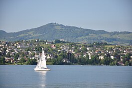
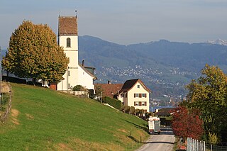
Feldbach is a village near Rapperswil, Switzerland. It is located on the north bank of the lake of Zurich and is part of the political municipality of Hombrechtikon. In the local dialect it is called Fäldbach.

<span class="mw-page-title-main">Pfäffikersee</span>

Pfäffikersee is a lake in the canton of Zürich, Switzerland, near the town of Pfäffikon. It is 2.5 km long and 1.3 km wide at the middle. The lake was created in the last ice age when a moraine blocked off the ability for the lake to empty north towards Winterthur. There is also a hiking trail around the lake that people often bike and walk on, and the area is considered protected lands, among them the Robenhauser Ried and the prehistoric settlement Wetzikon–Robenhausen, discovered and researched by Jakob Messikommer (1828–1917), which became a serial site of the UNESCO World Heritage Site Prehistoric pile dwellings around the Alps. In Roman era, along Pfäffikersee there was a Roman road from the vicus Centum Prata (Kempraten) on Obersee–Lake Zürich via Vitudurum (Oberwinterthur) to Tasgetium (Eschenz) to the Rhine. To secure this important transport route, the Irgenhausen Castrum was built.

<span class="mw-page-title-main">Jona, Switzerland</span> Former municipality of Switzerland in St. Gallen

Jona is a former municipality and since January 2007 part of the municipality of Rapperswil-Jona in the Wahlkreis (constituency) of See-Gaster in the canton of St. Gallen in Switzerland. Before the merger with Rapperswil, the former municipality of Jona comprised the villages of Jona, Bollingen, Busskirch, Curtiberg, Kempraten-Lenggis, Wagen and Wurmsbach.

<span class="mw-page-title-main">Rapperswil</span> Former municipality of Switzerland in St. Gallen

Rapperswil is a former municipality and since January 2007 part of the municipality of Rapperswil-Jona in the Wahlkreis (constituency) of See-Gaster in the canton of St. Gallen in Switzerland, located between Obersee and the main part of Lake Zurich.

<span class="mw-page-title-main">Rapperswil Castle</span> Castle in Switzerland

Rapperswil Castle is a castle, built in the early 13th century by the House of Rapperswil, in the formerly independent city of Rapperswil.

<span class="mw-page-title-main">Bollingen</span>

Bollingen is a village (Kirchdorf) within the municipality of Rapperswil-Jona in the Swiss canton of St. Gallen.

<span class="mw-page-title-main">Rapperswil railway station</span> Railway station in Switzerland

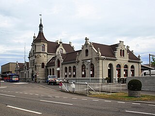
Rapperswil railway station is located next to the old town and harbour of Rapperswil in the Swiss canton of St. Gallen. It is the largest of four active railway stations in the municipality of Rapperswil-Jona. Rapperswil railway station is situated on the north shore of Lake Zürich at the northern end of the Seedamm, which separates the Obersee from the main body of the lake.

<span class="mw-page-title-main">Busskirch</span>

Busskirch is a village (Kirchdorf) within the municipality of Rapperswil-Jona in the canton of St. Gallen, Switzerland.

<span class="mw-page-title-main">Holzbrücke Rapperswil-Hurden</span> Wooden pedestrian bridge crossing the Obersee part of Lake Zurich in Switzerland

Holzbrücke Rapperswil-Hurden is a wooden pedestrian bridge between the city of Rapperswil and the village of Hurden crossing the Obersee in Switzerland. On 6 April 2001, the footbridge was opened. With a length of 841 metres (2,759 ft) it is the longest wooden bridge in Switzerland.

<span class="mw-page-title-main">Hurden</span> Former municipality in Schwyz, Switzerland

Hurden is a village in the municipality of Freienbach in the canton of Schwyz in Switzerland. First mentioned in 1217, the name "de Hurden" was used for the peninsula and for the fish traps made of woven work, called "Hürden" or "Hurden", which were used by the locals.

<span class="mw-page-title-main">Stadtmuseum Rapperswil-Jona</span> Museum in Rapperswil-Jona, Switzerland

Stadtmuseum Rapperswil-Jona is a museum of local history and art in Rapperswil, canton of St. Gallen in Switzerland.

<span class="mw-page-title-main">Verkehrsbetriebe Zürichsee und Oberland</span>

Verkehrsbetriebe Zürichsee und Oberland (VZO) is a public transport operator in the region between Lake Zürich and the Zürcher Oberland to the south-east of the city of Zürich in the canton of Zürich. It operates bus services between the various communities of this region and, since 2008, in the adjoining municipality of Rapperswil-Jona in the canton of St Gallen.

<span class="mw-page-title-main">Frauenwinkel</span> Mire landscape in Switzerland

Frauenwinkel is a mire landscape in Switzerland, situated at the Seedamm area on Zürichsee lakeshore in the municipality of Freienbach in the Canton of Schwyz.

<span class="mw-page-title-main">Centum Prata</span> Former Roman vicus in Switzerland

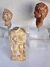
Centum Prata is the name of a Roman vicus, whose remains are located on the eastern Zürichsee lakeshore in Kempraten, a locality of the municipality Rapperswil-Jona in the canton of St. Gallen in Switzerland. Centum Prata is the most important archaeological site from the Gallo-Roman era in the canton of St. Gallen.

<span class="mw-page-title-main">Prehistoric pile dwellings around Lake Zurich</span> UNESCO World Heritage Site in Cantons of Schwyz, St. Gallen and Zürich in Switzerland

Prehistoric pile dwellings around Lake Zurich are pile dwelling sites located around Lake Zurich in the cantons of Schwyz, St. Gallen and Zürich.

<span class="mw-page-title-main">Freienbach–Hurden Rosshorn</span> UNESCO World Heritage Site in Canton of Schwyz, Switzerland

Freienbach–Hurden Rosshorn, more often called Hurden Rosshorn or simply Rosshorn, is one of the 111 serial sites of the UNESCO World Heritage Prehistoric pile dwellings around the Alps, of which are 56 located in Switzerland. The Rosshorn site is exceptional because it doesn't contain remains of a prehistoric settlement but instead remains of prehistoric and historic bridges that were built in a shallow area of Lake Zurich.

<span class="mw-page-title-main">Rapperswil-Jona/Hombrechtikon–Feldbach</span> Archaeological site in Switzerland

Rapperswil-Jona/Hombrechtikon–Feldbach is one of the 111 serial sites of the UNESCO World Heritage Site Prehistoric pile dwellings around the Alps, of which are 56 located in Switzerland.

<span class="mw-page-title-main">Rapperswil-Jona–Technikum</span> Archaeological site in Switzerland

Rapperswil-Jona–Technikum is one of the 111 serial sites of the UNESCO World Heritage Site Prehistoric pile dwellings around the Alps, of which are 56 located in Switzerland. It is a small former island in the upper Lake Zürich in Rapperswil, a locality of the municipality of Rapperswil-Jona in the Canton of St. Gallen.

References

  1. "Prehistoric Pile Dwellings in Switzerland". Swiss Coordination Group UNESCO Palafittes (palafittes.org). Archived from the original on 2014-10-07. Retrieved 2014-12-07.
  2. "World Heritage". palafittes.org. Archived from the original on 2014-12-09. Retrieved 2014-12-08.
  3. 1 2 "Schweizerisches Inventar der Kulturgüter von nationaler Bedeutung: Kanton St. Gallen, A-Objekte" (PDF) (in German). bevoelkerungsschutz.admin.ch. 2015-01-01. Archived from the original (PDF) on 2015-12-19. Retrieved 2015-09-14.
  4. "Sites Switzerland: Rapperswil-Jona/Hombrechtikon–Feldbach (CH-SG-02)". palafittes.org. Archived from the original on 2014-10-07. Retrieved 2014-12-08.
  5. D. Hintermann: Der römische Vicus von Kempraten. In: HA 106-108, 1996, p. 128-136.
  6. G. Matter: Der römische Vicus von Kempraten. In: JbSGUF 82, 1999, p. 183-211.
  7. L. Kilger: Wallfahrts-Geschichten aus Kempraten um das Jahr 835. In: Heimatkunde vom Linthgebiet, Band 15, 1943, p. 9-12.
  8. "Stadtbus Rapperswil-Jona".
  9. "Marktgebiet" [Market area] (in German). VZO. Archived from the original on 2013-10-04. Retrieved 2013-10-02.