History
The Kennemerland was an armed merchantman of the Dutch East India Company (Vereenigde Oost-Indische Compagnie; VOC). The Amsterdam Chamber of the VOC bought the Kennemerland in 1661 for 33,000 guilders. Measured in Dutch feet, it was 155 ft long, 35 ft wide and 17 ft 6in deep. The cargo rafters were 7 ft high. It was armed with 24 cast iron guns, six bronze guns and two minions, typical for a ship of its type at the time.
The ship made its maiden voyage for the VOC between 17 April 1662 and 25 August 1664, sailing from the Texel to Batavia (now Jakarta, Indonesia) and back. The Kennemerland and its companion the Rijnland left the Texel on 14 December 1664 with a crew of 200. They carried 240,000 guilders and a general cargo. Since the Netherlands was on the verge of war with England, the captain was directed to take the northern route around the Shetland Islands rather than the shorter English Channel route, where the risk of capture would have been greater.
Recent surveys and excavation
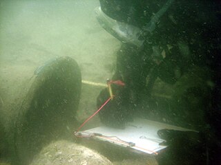
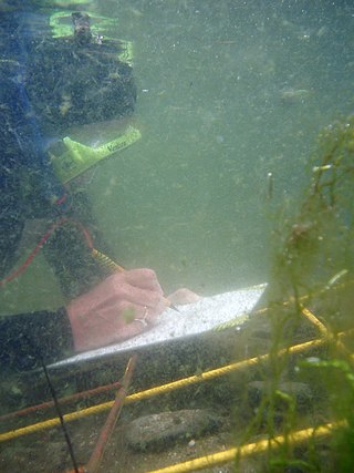
The wreck was relocated and surveyed in July–August 1971 by a team from Aston University working for Lerwick's Zetland Country Museum. The Kennemerland wreck site was meticulously explored and excavated in the 1970s using the latest technology available at the time. The team started by carefully mapping the area holding the wreck to an accuracy of less than 1 metre (3 ft 3 in). Divers from Aston and Manchester Universities excavated about 90 square metres (970 sq ft) of the sea bed during the summers of 1973 and 1974. They found about 10,000 items, which were deposited in the Lerwick Museum. Because of lack of legal protection for underwater historical sites, the site could only be protected from looting by removing all the artifacts, so further excavations were planned. To some extent the divers had to improvise marine archaeology techniques for excavation and analysis.
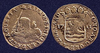
When the items known to have been salvaged soon after the wreck are counted with those excavated in 1973 and 1974 there were 15 cannon, ten cannon balls, large quantities of musket shot and scatter shot, and various munitions accessories. There were sails, rigging, 10 anchors, ballast bricks, iron, lead and nails. There were three navigation instruments, 61 coins and 35 pieces of jewelry. Various personal items were found as well as quills, writing paper and about 150 clay tobacco pipes. Various different pipe styles were found. The "EB" clay pipes were made by Eduard Bird (c. 1610–1665) of Amsterdam. There were bridle bits and stirrup irons, tar, tallow, rosin, mercury, olive oil, brandy, wine, vinegar, beer, preserved fruits, butter, flour and meat. The ship also carried shoes, linen, serge, woolen cloth and other cloth. It is likely that more coins were salvaged, but these were hidden from Morton's agents by the islanders, who may also have consumed some of the brandy and wine.
The Archaeology student Keith Muckelroy of Jesus College, Cambridge University learned to dive in 1971. He participated in the 2nd and 3rd seasons of excavation of the Kennemerland, and wrote several reports on the subject. He quickly became one of the leading practitioners and theoreticians in the new field of Marine Archaeology. His 1976 The Integration of Historical and Archaeological Data concerning an Historic Wreck Site: The 'Kennemerland' introduced the concept of five processes that affect a shipwreck. The processes of wrecking, salvage operations and disintegration of perishables all remove material. The wreck is also affected by seabed movement and the method of excavation. Material deposited on the site after the shipwreck adds a further factor to what is observed when the site is excavated.
The wreck was designated a Historic Marine Protected Area due to its national importance. Forty years later a team from Cotswold Archaeology was sent by Historic Scotland to review and revise the plans of the Kemmerland based on the remnants still on the seabed using GIS technology.
Maritime archaeology is a discipline within archaeology as a whole that specifically studies human interaction with the sea, lakes and rivers through the study of associated physical remains, be they vessels, shore-side facilities, port-related structures, cargoes, human remains and submerged landscapes. A specialty within maritime archaeology is nautical archaeology, which studies ship construction and use.

Batavia ( ) was a ship of the Dutch East India Company (VOC). She was built in Amsterdam in 1628 as the flagship of one of the three annual fleets of company ships and sailed that year on her maiden voyage for Batavia, capital of the Dutch East Indies. On 4 June 1629, Batavia was wrecked on the Houtman Abrolhos, a chain of small islands off the western coast of Australia.
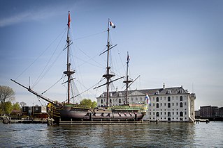
The Amsterdam was an 18th-century cargo ship of the Dutch East India Company. The VOC was established in 1602. The ship started its maiden voyage from Texel to Batavia on 8 January 1749, but was wrecked in a storm on the English Channel on 26 January 1749. The shipwreck was discovered in 1969 in the bay of Bulverhythe, near Hastings on the English south coast, and is sometimes visible during low tides. The location in 1969 was found by Bill Young, the site agent/project manager for the sewage outfall being built by the William Press Group. With time on his hands during the long stay away from home, he followed up the rumour of the going aground. He was castigated by the Museum of London for scooping out the interior of the bow with a digger as it could have led to the structure collapsing. However, it uncovered the initial items which led to a more extensive excavation of the cargo which reflected life at the time. The wreck is a Protected Wreck managed by Historic England. Some of the findings from the site are in The Shipwreck Museum in Hastings. A replica of the ship is on display in Amsterdam.
Underwater archaeology is archaeology practiced underwater. As with all other branches of archaeology, it evolved from its roots in pre-history and in the classical era to include sites from the historical and industrial eras.
Zuytdorp, also Zuiddorp was an 18th-century trading ship of the Dutch East India Company.
The Out Skerries are an archipelago of islets, some inhabited, in Shetland, Scotland, and are the easternmost part of Shetland. Locally, they are usually called Da Skerries or just Skerries.
The Rooswijk was a ship belonging to the VOC that, according to recent, non-contemporary, news reports, sank in 1740. The wreck is a Protected Wreck managed by Historic England.
The Vergulde Draeck, also spelled Vergulde Draak and Vergulde Draek, was a 41.8-metre (137 ft), 260-tonne (290-ton) ship constructed in 1653 by the Dutch East India Company.

The archaeology of shipwrecks is the field of archaeology specialized most commonly in the study and exploration of shipwrecks. Its techniques combine those of archaeology with those of diving to become Underwater archaeology. However, shipwrecks are discovered on what have become terrestrial sites.

The Zeewijk was an 18th-century East Indiaman of the Dutch East India Company that was shipwrecked at the Houtman Abrolhos, off the coast of Western Australia, on 9 June 1727. The survivors built a second ship, the Sloepie, enabling 82 out of the initial crew of 208 to reach their initial destination of Batavia on 30 April 1728. Since the 19th century many objects were found near the wreck site, which are now in the Western Australian Museum. The shipwreck itself was found in 1968 by divers.
Keith Muckelroy (1951-1980) was a pioneer of maritime archaeology. Instead of the traditional particularist or historiographic approach used by maritime archaeologists, Muckelroy's ideas were new to the field, influenced by the prehistoric and analytical archaeology he learned under Grahame Clark and David Clarke at Cambridge, the tenets of processual archaeology gaining traction in the U.S., and his own experiences on shipwreck sites in British waters, notably the 1664 Dutch East Indiaman Kennemerland, several Spanish Armada wrecks, and the Mary Rose.
Mensun Bound is a British maritime archaeologist born in Stanley, Falkland Islands. He is best known as director of exploration for two expeditions to the Weddell Sea which led to the rediscovery of the Endurance, in which Sir Ernest Shackleton and a crew of 27 men sailed for the Antarctic on the 1914–1917 Imperial Trans-Antarctic Expedition. The ship sank after being crushed by the ice on 21 November 1915. It was rediscovered by the Endurance22 expedition on 5 March 2022.
The Hội An wreck lies in the South China Sea 22 nautical miles off the coast of central Vietnam at approximately 16.04°N 108.6°E approximately. It was discovered by fishermen in the early 1990s. The Vietnamese government made several attempts to organise an investigation of the site but its efforts initially were confounded by the water depth of 230 feet (70 m). Between 1996 and 1999, the team, which included the Vietnamese National Salvage Corporation and Oxford University’s Marine Archaeology Research Division, recovered nearly 300,000 artifacts.

Yell Sound is the strait running between Yell and Mainland, Shetland, Scotland. It is the boundary between the Mainland and the North Isles and it contains many small islands. Sullom Voe, on the shores of which is a substantial oil terminal, is an arm of Yell Sound.
The Mary Rose Trust is a limited charitable trust based in Portsmouth in the United Kingdom. Its primary aims are to preserve, display and spread knowledge about the 16th century warship Mary Rose which sank in the Solent on 19 July 1545 and was salvaged by the Trust in October 1982.
The Dokos shipwreck is the oldest underwater shipwreck discovery known to archeologists. The wreck has been dated to the second Proto-Helladic period, 2700–2200 BC.

The Belitung shipwreck is the wreck of an Arabian dhow which sank around 830 AD. The ship completed the outward journey from Arabia to China, but sank on the return journey from China, approximately 1.6 kilometres (1 mi) off the coast of Belitung Island, Indonesia. It is unclear why the ship was south of the typical route when it sank. Belitung is to the south-east of the Singapore Strait by 610 kilometres (380 mi), and this secondary route is more normal for ships travelling between China and the Java Sea, which is south of Belitung Island.
The Australian Netherlands Committee on Old Dutch Shipwrecks (ANCODS) is an organization tasked with maintaining and allocating artefacts from 17th and 18th century Dutch shipwrecks off the coast of Western Australia. It was founded in 1972 by the Agreement between Australia and the Netherlands Concerning Old Dutch Shipwrecks.
Discovered by divers from the French Navy Diving School in 1967, the archaeological investigations of the Roman wreck at Madrague de Giens constituted the first large scale, "truly scientific underwater excavation[s] carried out in France". The wreck lies at around 18 to 20 metres depth off the coast of the small fishing port of La Madrague de Giens on the Giens Peninsula, east of Toulon, on the southern Mediterranean coast of France. Sunk around 75–60 BCE, the vessel has been found to be "a large merchantman of considerable tonnage—400 tons deadweight with a displacement of around 550 tons", making it one of the largest Roman wrecks excavated, with only the wreck at Albenga, Italy exceeding it at the time of its discovery. The vessel wrecked at Madrague de Giens measured around 40 metres in length; has a "wine glass" section which would have given better ability to sail to windward; displayed extended raking of the stem and stern; and had two masts. The hull was characterised by a reverse stempost in the shape of a ram with a big cutwater which "must have given... [the] craft high-performance sailing qualities". The ship sank while transporting a large cargo of wine and black glazed pottery from Italy. It is not known why it sank.
San Esteban was a Spanish cargo ship that was wrecked in a storm in the Gulf of Mexico on what is now the Padre Island National Seashore in southern Texas on 29 April 1554.
