
New Circle Road, also known as Kentucky Route 4, is a Kentucky state highway that serves as an inner beltway around Lexington, which is part of the consolidated city-county government with Fayette County.

New York State Route 78 (NY 78) is a 73.49-mile-long (118.27 km) state highway in western New York in the United States. While it is signed north–south, the southern portion runs in an east–west direction across Wyoming and Erie counties, from its beginning at a junction with NY 19 north of the village of Gainesville to the village of East Aurora. The part of the route north of East Aurora follows a generally north–south alignment to an intersection with NY 18 in the Niagara County town of Newfane, just south of the Lake Ontario shoreline. The route is most closely identified in the region with Transit Road, a major north–south trunk road through the center of Erie and Niagara counties; however, NY 78 does not follow Transit Road for its entire length, nor does Transit Road comprise more than half its length. The highway joins Transit Road north of East Aurora and stays with the road until nearly its end in the city of Lockport.

Kentucky Route 29 is an 11.324-mile-long (18.224 km) state highway located entirely within Jessamine County in the U.S. state of Kentucky. The highway, maintained by the Kentucky Transportation Cabinet, runs north from High Bridge, Kentucky through Wilmore before ending at Nicholasville. Within Wilmore, KY 29 intersects Kentucky Route 1268 and junctions with Kentucky Route 3433. The highway acts as the border between Asbury University and Asbury Theological Seminary. Just north of Wilmore, KY 29 merges with U.S. Route 68 for 0.590 miles (0.950 km) before leaving US 68 and turning east heading towards Nicholasville. KY 29 terminates at Kentucky Route 39 and U.S. Route 27 Business in downtown Nicholasville.

Kentucky Route 922 is a 20.201 miles (32.510 km) long state highway in northern Kentucky. The southern terminus of the route is at U.S. Route 27 and U.S. Route 68 in Lexington. The northern terminus is at Kentucky Route 620 north of Georgetown. From US 27/68 north to US 25, KY 922 is named Oliver Lewis Way. From US 25 north to U.S. Route 62, it is named Newtown Pike. Between New Circle Rd and Interstate 75, Newtown Pike is one of the most congested routes during rush hour.

Kentucky Route 693 is a 5.812-mile-long (9.354 km) east–west state highway located within Greenup County in the U.S. state of Kentucky. The western terminus of the route is at U.S. Route 23 in Wurtland. The eastern terminus is at US 23 in Russell. KY 693 is also known as Diedrich Boulevard in Russell and Bellefonte Road in Flatwoods.
Man o' War Boulevard, named after the racehorse Man o' War, is an almost 17-mile (27 km) urban arterial, circling Lexington, Kentucky to its south. Its western terminus is at US 60 / Keeneland Boulevard at Keeneland Race Course's main entrance, from which the highway heads southeast, intersecting with US 68, US 27, and other roads. It then turns east and northeast, intersecting KY 1974, US 25/US 421, and I-75, before ending at US 60 at Brighton. The majority of the road is a four-lane divided highway with curbs and sidewalks maintained by the Lexington-Fayette Urban County Government, but the 1.429-mile (2.300 km) portion east of I-75 is maintained by the Kentucky Transportation Cabinet as Supplemental Road Kentucky Route 1425, and only carries two lanes.

Kentucky Route 1065 is a 13.856-mile-long (22.299 km) state highway located in Louisville, Kentucky. The western terminus of the route is at Kentucky Route 907 a short distance west of Kentucky Route 841 exit 6 in the Louisville neighborhood of Auburndale. The eastern terminus is at Kentucky Route 1819 in Fern Creek.

Kentucky Route 321 originates at a junction with U.S. Highway 23 north of Paintsville, Kentucky in Johnson County, Kentucky, United States. The route continues through Johnson County to terminate at KY 1428 in Prestonsburg in Floyd County.

Interstate 75 (I-75) is a part of the Interstate Highway System that runs 1,786.47 miles (2,875.04 km) from Miami Lakes, Florida to the Canada–United States border at Sault Ste. Marie, Michigan. In the U.S. state of Kentucky, I-75 runs through the eastern half of the state, from the Tennessee state line near the city of Williamsburg to the Ohio state line near Covington. The Interstate serves the state's second-most populous city, Lexington. Outside of it, the route is mostly rural or suburban in nature, mainly providing access to other cities via state and U.S. Highways. The major landscapes traversed by I-75 include the rolling hills and mountains of the Cumberland Plateau, the flat Bluegrass region, the urban core of Lexington, and the highly urbanized suburbs of Northern Kentucky; it also very briefly crosses through the Eastern Kentucky Coalfield at its southernmost stretch and passes near the Daniel Boone National Forest in London.

Kentucky Route 1303 is a 6.397-mile-long (10.295 km) state highway in Kenton County, Kentucky. The southern terminus of the route is at KY 536 in Independence. The northern terminus is at U.S. Route 25, U.S. Route 42 and U.S. Route 127 in Lakeside Park. On its way to KY 536 it goes through many towns. These towns include Edgewood, Erlanger, and Independence. The southernmost segment of the route is named Bristow Road, a moniker carried by KY 536 east of KY 1303. At Richardson Road in Independence, KY 1303 becomes Turkeyfoot Road, a name the route retains to its northern terminus.
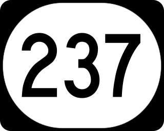
Kentucky Route 237 is a 14.872-mile-long (23.934 km) state highway in Boone County, Kentucky, connecting the Florence/Burlington area with Hebron. The southern terminus of the route is at KY 536 in Florence. The northern terminus is at KY 8 near Hebron. Most of the land surrounding KY 237 is residential.

Kentucky Route 259 is a 95.91-mile-long (154.35 km) state highway that traverses five counties in west-central Kentucky.

Kentucky Route 35 is a 12.833-mile-long state highway in Kentucky that runs from US 127 in Owen County south of Sparta and heads north and goes through Sparta and meets KY 467 before meeting Interstate 71. KY 35 then passes by the Kentucky Speedway and comes to an end at US 42 in Warsaw.

Kentucky Route 1681 is a 21.448-mile (34.517 km) state highway in Kentucky that runs from Kentucky Route 1659 immediately north of Millville to U.S. Route 60, Kentucky Route 922, and Manchester Street on the northwestern side of downtown Lexington.

Kentucky Route 353 (KY 353) a 19.940-mile-long (32.090 km) state highway in the U.S. state of Kentucky. The highway is a major route in Lexington, connecting Bourbon and Harrison counties with the city.

Kentucky Route 418 (KY 418) is a 11.736-mile-long (18.887 km) state highway in the U.S. state of Kentucky. The highway is a major connector for Lexington and Interstate 75. It was previously a Fayette County road that was rebuilt and numbered when the interstate was built. East of I-75, it serves the community of Athens and rural areas of Fayette and Clark counties.

