Kerse Loch

Last updated

Kerse Loch
Kerse Loch.jpg
Kerse Loch from the north-west
Scotland relief location map.jpg
Red pog.svg
Kerse Loch
The location of Karse Loch, East Ayrshire
Location Dalrymple, East Ayrshire, Scotland
Coordinates Coordinates: 55°23′53.3″N4°29′22.1″W / 55.398139°N 4.489472°W / 55.398139; -4.489472
Lake type Freshwater loch
Primary inflows Rainfall and runoff
Primary outflows Kerse Burn.
Basin  countriesScotland
Settlements Dalrymple

Kerse Loch (NS 34894 16186), also recorded as Carse Loch (1841) [1] is a small freshwater loch in the East Ayrshire Council Area, lying in a glacial Kettle Hole, Parish of Dalrymple, Scotland.

Contents

The loch

Etymology

Carse, Cars, and Kerse in Scots refers to Low and fertile land; generally, that which is adjacent to a river or water body. The name appears to have originally referred to 'flat lands’ of a wet fenny and character, later associated with rich fertility. [2]

Cartographic evidence

The Kerse Burn near the old Kerse Tileworks draining the loch. Kerse Burn.jpg
The Kerse Burn near the old Kerse Tileworks draining the loch.
The Kerse Burn over the Bow burn near the old Kerse Castle. Kerse Bridge, Bow Burn.jpg
The Kerse Burn over the Bow burn near the old Kerse Castle.

Robert Gordon's map of circa marks the loch and the castle of Cars (sic) nearby. [3] 1636-52Blaeu map of circa 1654 taken from Timothy Pont's map of circa 1600 shows the Kars Loch (sic) and nearby Cars Castle (sic) with substantial grounds and woodland. [4] Molls map of 1745 shows the loch and also shows the castle lying to the east. [5] Roy's map of 1747 records the loch as Carse and the castle is located to the east. A burn running from the west is shown as feeding the loch. [6] In 1821 the loch is clearly shown and 'Kerse' is shown towards the Sundrum Water. [7] In 1832 Thomson's map shows the 'Carse Loch' with a small inflow burn and 'Carse' dwelling on a road to the east. [8]

Uses

Curling matches are recorded as having taken place at the loch in 1874 and on 24 December 1846. [1]

The loch is mainly fed by rainfall and runoff and the Loch Kerse Burn runs down to join the Water of Coyle, however no mills appear to have been sited along the burns length. The Kerse Burn has been canalised and deepened along its length. By 1978 the railway close to the southern loch shore had been lifted and a boathouse had been established on the northern bank. [9]

Situation

The loch lies below Broom Hill and the heights of the Craigs of Kyle, and on its banks is supposedly the site of Kerse Castle, [10] one time stronghold of the Crawfurd clan before the family moved to nearby Skeldon House. [11] The old maps consistently show the castle as lying well to the east of the loch beside the Bow Burn.

Kerse Castle

Kerse Castle (NS 306 508) [12] was the stronghold of David Craufurd, the laird of Kerse and only a few stones may mark the old castle's position, supposedly not far from the Kerse Park Farm, however this is not proven. [13] The first record of the castle is from 1281 and its demise is said to have been in 1797 when it was blown down in a storm. [11] Reginald, first of the Kerse Craufurds, got a grant of the lands of Kerse from his brother Hugh, in the reign of King Alexander III (1249-1286). [14]

The Flitting of the Sow

The old woodland policies of Kerse Castle. Kerse Castle policies.jpg
The old woodland policies of Kerse Castle.

A legend linked to the castle and loch is 'The flitting of the Sow' which relates to ongoing feuds between the Kennedys of Carrick and the Craufurds of Kyle. Three days before Lammastide, namely 29 July, Gilbert Kennedy came to Kerse Castle and informed the old Laird of Kerse that his clan would be tethering a sow on their land on Lammas Day. This insult and challenge resulted in the clans gathering all their supporters and on Lammas Day, 1 August, the lairds eldest son, Elspin, lead the clan into battle against the Kennedys on the Craufurds lands at the holms of Skeldon. In the ensuing fighting, John the lairds other son, was killed however the Craufurds eventually drove the Kennedys back into Carrick, a number drowning in the River Doon as they tried to escape. [15]

The old laird had been too infirm to take part and had remained impatiently at the castle looking out over the Kerse Loch for any sign of a messenger from Elspin. At last a rider came into sight and the report was that his son John had been killed, however the Craufurds were triumphant and the sow had been flitted (removed). [15] [16]

Alexander Boswell of Auchinleck, a descendant of the combatants, wrote a poem upon the subject, entitled Skeldon Haughs; or, the Sow is flitted. [17]

Natural history

The loch in 1846 was well stocked with pike, perch, and eels, and was frequented by wild-duck, teal, widgeon, and other aquatic fowl. [18] The loch is part of the Wetland Bird Survey (WEBS). [19]

Geology

The Southern Upland Fault is accompanied by a group of associated faults subparallel to the main fault, including Kerse Loch Fault, Littlemill Fault, Leadhills Fault and Glenmuir Fault. The former two mark the southern edge of the deepest part of Mauchline Basin. A series of lesser faults subparallel also transect the region and the intersection of the two fault trends has created a large number of discrete fault-bounded blocks. [20]

Micro history

During the 1926 coal miners strike the farmer from Kerspark Farm would cross the loch on the ice to buy coal from the miners who were extracting from the old bings at Cairntable. On one occasion the cart broke through the ice and was abandoned where it sank. [21]

People from Cairntable miner's rows often swam in the loch, especially the children. The girls swimming site was called the 'Coo-Creep'. [21]

Cairntable Halt was located nearby at the miner's village of that name and close to Knockshinnoch Farm.

A Kerse House near Grangemouth is on the site of a castle and latterly was held by the Dundas family, later Marquises of Zetland. [12]

See also

Related Research Articles

<span class="mw-page-title-main">Carse</span>

In Scottish geography, a Carse is an area of fertile, low-lying land occupying certain Scottish river valleys, such as that of the River Forth.

<span class="mw-page-title-main">Dunduff Castle</span> Castle in Ayrshire, Scotland

Dunduff Castle is a restored stair-tower in South Ayrshire, Scotland, built on the hillside of Brown Carrick Hills above the Drumbane Burn, and overlooking the sea above the village of Dunure.

<span class="mw-page-title-main">Hill of Beith Castle</span>

The old Barony and castle, fortalice, or tower house of Hill of Beith lay in the feudal Regality of Kilwinning, within the Baillerie of Cunninghame, and the Sherrifdom of Ayr, now the Parish of Beith, North Ayrshire, Scotland.

<span class="mw-page-title-main">Trindlemoss Loch</span> Body of water

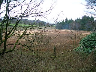
Trindlemoss Loch, Scott's / Scot's Loch or the Loch of Irvine was situated in a low-lying area running from Ravenspark to near Stanecastle and down to Lockwards, now represented only by the playing fields off Bank Street in the Parish of Irvine, North Ayrshire, Scotland. The loch was natural, sitting in a hollow created by glaciation. The loch waters were progressively drained and in 1691 this was finally achieved.

<span class="mw-page-title-main">Hessilhead Loch</span> Body of water

Hessilhead Loch or Hazelhead Loch was situated in a low-lying area near the old Castle of Hessilhead in the Parish of Beith, North Ayrshire, Scotland. The old loch, used in the defence of the castle, was probably infilled when the castle ruins were landscaped in the 19th century.

<span class="mw-page-title-main">Galrigs Loch (South Ayrshire)</span> Body of water

The Galrigs Loch was a substantial freshwater loch situated in low lying area between Newfield and Dundonald in South Ayrshire, Scotland. It was drained in the early 18th century.

<span class="mw-page-title-main">Loch of Trabboch</span> Body of water

The Loch of Trabboch or Dalrympleston Loch (NS440211) was situated in a low-lying area below the old Castle of Trabboch, once held by the Boyd family in the Parish of Stair, East Ayrshire, Scotland.

<span class="mw-page-title-main">Polkelly Castle</span>

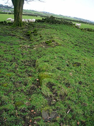
Polkelly Castle, also Pokelly, was an ancient castle located near Fenwick, at NS 4568 4524, in the medieval free Barony of Polkelly, lying north of Kilmarnock, Parish of Fenwick, East Ayrshire, Scotland. The castle is recorded as Powkelly (c1747), Pockelly (c1775), Pow-Kaillie, Ponekell, Polnekel, Pollockelly, Pollockellie, Pokellie, Pothelly, Pathelly Ha' and Polkelly. The name is given circa 1564 as Powkellie when it was held by the Cunninghams of Cunninghamhead.

<span class="mw-page-title-main">Martnaham Loch</span> Body of water

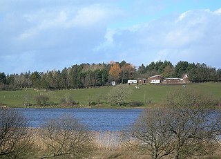
Martnaham Loch is a freshwater loch lying across the border between East and South Ayrshire Council Areas, two kilometres from Coylton, in the parishes of Coylton and Dalrymple, three miles from Ayr. The loch lies along an axis from northeast to southwest. The remains of a castle lie on a possibly artificial islet within the loch. The Campbells of Loudoun once held the lands, followed by the Kennedys of Cassillis.

<span class="mw-page-title-main">Auchenbathie Tower</span>

Auchenbathie, Auchinbathie Tower or rarely Barcraigs Tower is a ruined fortification, a tower house, once held by the Wallace Clan of Elderslie, situated in Renfrewshire, Parish of Lochwinnoch, Scotland. The spelling used varies greatly and "Auchenbathie" will be used here as the standard spelling. The pronunciation locally is "Auchenbothy", the same as a Victorian mansion in Kilmacolm; no connection is known.

<span class="mw-page-title-main">Kerse Castle, East Ayrshire</span>

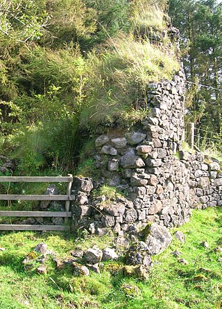
Kerse Castle or Carse Castle is a ruined fortification once held by the Craufurd Clan, situated in the Parish of Dalrymple, East Ayrshire, Scotland.

<span class="mw-page-title-main">Auchencloigh Castle</span> Ruined fortification in the Parish of Ochiltree, East Ayrshire, Scotland

Auchencloigh Castle or Auchincloigh Castle is a ruined fortification near the Burnton Burn, lying within the feudal lands of the Craufurd Clan, situated in the Parish of Ochiltree, East Ayrshire, Scotland.

<span class="mw-page-title-main">Belston Loch</span> A lake in east Ayrshire, Scotland

Belston Loch, also recorded as Dromsmodda Loch is a small freshwater loch in the East Ayrshire Council Area, near Sinclairston, 2 miles south-east of Drongan, lying in a glacial Kettle Hole. Parish of Ochiltree, Scotland.

Plaid Loch was a freshwater loch in East Ayrshire, now a remnant due to drainage, near Sinclairston and 2 miles (3 km) south-east of Drongan, lying in a glacial kettle hole,.

<span class="mw-page-title-main">Loch Shield</span> Body of water

Loch Shield, originally Loch of Scheel was a freshwater loch in the East Ayrshire Council Area, now drained, near Drongan, lying in a glacial Kettle Hole, Parish of Ochiltree, Scotland.

<span class="mw-page-title-main">Barony of Kersland</span>

The remains of the old castle of Kersland lie about 1.5 miles to the north-east of the town of Dalry in North Ayrshire, Scotland, in the old Barony of Kersland. The River Garnock lies nearby.

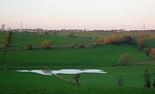
Carse Loch is situated in a low-lying area, surrounded by woodland, close to the A76 at Friar's Carse, in Dumfries and Galloway, Parish of Dunscore. It was once used as a monastic fish pond and the friars are said to have hidden their treasures on the crannog in times of danger. The loch is located about 7 miles from Dumfries and 2 miles from Auldgirth.

<span class="mw-page-title-main">Lefnoreis Castle</span>

The site of the old Lefnoreis Castle or Ward of Lochnorris lies about 100 yards north-west of the old stable block of Dumfries House in East Ayrshire, Parish of Old Cumnock, Scotland. The old castle stood on a natural rise overlooking the Lugar Water, built and held for many years by the Craufurd family. For consistency the spelling Craufurd will be used throughout and Lefnoreis for the castle.

The Lands of Dallars or Auchenskeith (NS463337) form a small estate in East Ayrshire, Hurlford, Kilmarnock, Parish of Riccarton, Scotland. The present mansion house is mainly late 18th-century, located within a bend of the Cessnock Water on the site of older building/s. "Dullers or Dillers" was changed to "Auchenskeith" or "Auchinskeigh" (sic) as well as other variants and then the name reverted nearer to the original form as "Dollars" and then finally "Dallars". Dallars lies 3.25 km south of Hurlford.

<span class="mw-page-title-main">Castle and Lands of Auchruglen</span> Scottish castle

The Castle and Lands of Auchruglen (NS5365436797) was a peel tower in the old district of Kyle held at different times by the Nesbitt and Campbell Clans and located near Newmilns, Parish of Galston, East Ayrshire, Scotland.

References

Notes

  1. 1 2 Curling Pond Sites retrieved : 2011-09-17
  2. Scots Dictionary Retrieved : 2011-09-17
  3. Gordon's Map Retrieved : 2011-09-17
  4. Blaeu's Map Retrieved : 2011-09-12
  5. Moll's Map Retrieved : 2011-09-17
  6. Roy's Map retrieved : 2011-09-17
  7. Ainslie Retrieved : 2011-09-12
  8. Thomson's Map Retrieved : 2011-09-12
  9. OS Map Archived 30 April 2012 at the Wayback Machine Retrieved : 2011-09-17
  10. Smith, Page 175
  11. 1 2 Love (2003), Page 278
  12. 1 2 Coventry, Page 129
  13. Campbell, Page 198
  14. Carrick Days Retrieved : 2011-09-18
  15. 1 2 Blair, Pages 160-163
  16. The Flitting of the Sow Archived 9 August 2011 at the Wayback Machine Retrieved : 2011-09-18
  17. Macintosh, Page 167
  18. Ayrshire Roots Retrieved : 2011-09-17
  19. WEBS Retrieved : 2011-09-18
  20. Kerse Loch Fault Retrieved : 2011-09-18
  21. 1 2 Reid, Page 164

Sources

  1. Blair, Anna (1983). Tales of Ayrshire. London : Shepeard - Walwyn. ISBN   0-85683-068-2.
  2. Campbell, Thorbjørn (2003). Ayrshire. A Historical Guide. Edinburgh : Birlinn. ISBN   1-84158-267-0.
  3. Coventry, Martin (2010). Castles of the Clans. Musselburgh : Goblinshead. ISBN   1-899874-36-4.
  4. Love, Dane (2003). Ayrshire : Discovering a County. Ayr : Fort Publishing. ISBN   0-9544461-1-9.
  5. MacIntosh, Donald (2006). Travels in Galloway. Glasgow : Neil Wilson. ISBN   1-897784-92-9.
  6. Reid, Donald L. (2012). The Lost Mining Villages of Doon Valley. Beith : D. L. Reid. ISBN   978-0-9566343-3-7.
  7. Smith, John (1895). Prehistoric Man in Ayrshire. London : Elliot Stock.