Keshendeh | |
|---|---|
 Keshendeh Location in Afghanistan | |
| Coordinates: 36°5′3″N66°50′25″E / 36.08417°N 66.84028°E | |
| Country | |
| Province | Balkh Province |
| Time zone | + 4.30 |
Keshendeh is a village in Balkh Province in northern Afghanistan. [1]
Keshendeh | |
|---|---|
| Keshendeh Location in Afghanistan | |
| Coordinates: 36°5′3″N66°50′25″E / 36.08417°N 66.84028°E | |
| Country | |
| Province | Balkh Province |
| Time zone | + 4.30 |
Keshendeh is a village in Balkh Province in northern Afghanistan. [1]
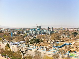
Mazar-i-Sharīf, also known as Mazar-e Sharīf or simply Mazar, is the fourth-largest city in Afghanistan by population, with an estimated 500,207 residents in 2021. It is the capital of Balkh province and is linked by highways with Kunduz in the east, Kabul in the southeast, Herat in the southwest and Termez, Uzbekistan in the north. It is about 55 km (34 mi) from the Uzbek border. The city is also a tourist attraction because of its famous shrines as well as the Islamic and Hellenistic archeological sites. The ancient city of Balkh is also nearby.

Balkh is a town in the Balkh Province of Afghanistan, about 20 km (12 mi) northwest of the provincial capital, Mazar-e Sharif, and some 74 km (46 mi) south of the Amu Darya river and the Uzbekistan border. Its population was recently estimated to be 138,594.

Afghanistan is divided into 34 provinces. The provinces of Afghanistan are the primary administrative divisions. Each province encompasses a number of districts or usually over 1,000 villages.

Balkh is one of the 34 provinces of Afghanistan, located in the north of the country. It is divided into 15 districts and has a population of about 1,509,183, which is multi-ethnic and mostly a Persian-speaking society. The city of Mazar-i-Sharif serves as the capital of the province. The Mazar-i-Sharif International Airport and Camp Marmal sit on the eastern edge of Mazar-i-Sharif.
Khulm or Khulmi is a district of Balkh province, Afghanistan. Its capital lies at Kholm. In 2019 the estimated population was 81,234.

Atta Muhammad Nur is an Afghan exiled politician and former militant who served as the Governor of Balkh Province in Afghanistan from 2004 to January 25, 2018. An ethnic Tajik, he worked to educate the Mujahideen after the 1979 Soviet invasion of Afghanistan, gaining the nickname "The Teacher". He then became a mujahideen resistance commander for the Jamiat-e Islami against the Soviets.

Juma Khan Hamdard is an Afghan politician. He served as the security adviser to President Ashraf Ghani. He served as governor of Paktia Province from 2007 to 2015, previously serving as governor of Baghlan and later Jowzjan province. He is the head of the alliance of H.A.A Councils.
Sholgara is a district in the southern part of Balkh Province, Afghanistan. Sholgara, just south of Mazari Sharif (Mazar), is strategically located at the crossroads between several districts: Sangcharak, Kishindih, Dar-I-Suf. Dar-I-Suf and Sangcharak are known for their resistance to the Taliban insurgency. It is commonly said that "who holds Sholgara, holds Mazar".
Zari is a district in Balkh province, Afghanistan. It was created in 2005 from part of Kishindih district.
Chārbōlak district is located in the western part of Balkh Province. Its capital is the village of Charbolak, 40 km northwest of Mazari Sharif. The majority of the population is Pashtun.
Chimtal District also Chemtal or Chamtal is a district located in the western part of Balkh province, Afghanistan. The estimated population of Chimtal in 2004 was around 81,311, with Pashtuns being predominant. The capital is Chimtal.

Dawlatabad District is a landlocked district, located in the northwestern part of Balkh province, in northern Afghanistan. The population is 101,900 people. The capital is the village of Dowlatabad at 298 m height above sea level.
Dihdadi District is situated in the central part of Balkh province, Afghanistan. It is not far from the capital of the province Mazari Sharif - about 15 km in eastern direction from the district capital Dihdadi.
Kaldar is a small district in the northern part of Balkh Province, Afghanistan. The northern and the eastern border of the district is the large Amu Darya river. North of the river is Uzbekistan and east is Tajikistan. The main village, also called Kaldar, is in the northeastern part of the district, close to the river. According to the inhabitants of this village, its original name is Kakoldar.
Kishindih or Kishindeh is the southernmost district in Balkh province. Its capital is Kishindinh Bala, situated in the northern part of the district.
Marmul is a small district, located in the central part of Balkh province in northern Afghanistan. The capital Marmul is in its southern end on the border with the Chahar Kint district.
Nahri Shahi or Nahr-e-Shahi is a large district of Balkh province, Afghanistan around the capital district Mazari Sharif.
Shortepa also Shor Tappeh is one of the 15 districts of Balkh province. Shortepa, a small district in Balkh Province, Afghanistan. It is situated along the Amu Darya river, across the border with Termez, Uzbekistan, and to the east Kaldar. The main village is Shor Tappeh, A at 274 m altitude.
Kheyrabad, Balkh is a village in Balkh Province in northern Afghanistan.

The COVID-19 pandemic in Afghanistan was a part of the worldwide pandemic of coronavirus disease 2019 caused by severe acute respiratory syndrome coronavirus 2. The virus was confirmed to have spread to Afghanistan when its index case, in Herat, was confirmed on 24 February 2020.
| | This Balkh Province, Afghanistan location article is a stub. You can help Wikipedia by expanding it. |