
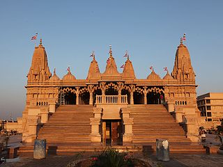
Porbandar is a city and the headquarters of Porbandar district in the Indian state of Gujarat. It is the birthplace of Mahatma Gandhi and Sudama. It was the former capital of the Porbandar princely state. Porbandar and Chhaya are the twin cities of each other and both cities are jointly governed by Porbandar–Chhaya Municipal Corporation.

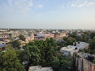
Rajkot is the fourth-largest city in the Indian state of Gujarat after Ahmedabad, Vadodara, and Surat, and is in the centre of the Saurashtra region of Gujarat. Rajkot is the 35th-largest metropolitan area in India, with a population of more than 2 million as of 2021. Rajkot is the 6th cleanest city of India, and it is the 902nd fastest-growing city in the world as of March 2021. The city contains the administrative headquarters of the Rajkot District, 245 km from the state capital Gandhinagar, and is located on the banks of the Aji and Nyari rivers. Rajkot was the capital of the Saurashtra State from 15 April 1948 to 31 October 1956, before its merger with Bombay State on 1 November 1956. Rajkot was reincorporated into Gujarat State on 1 May 1960.

Gokak is a taluka headquarters in the Belagavi district of Karnataka state, India. It is located around 70 km from Belagavi at the confluence of the Ghataprabha and Markandeya rivers. The population of the city is 79,121, according to the 2011 census. Gokak city has the second highest GDP in the district of Belagavi after Belagavi city. Kannada is the commonly spoken language.

Mtwara is the capital city of Mtwara Region in southeastern Tanzania. In the 1940s, it was planned and constructed as the export facility for the disastrous Tanganyika groundnut scheme, but was somewhat neglected when the scheme was abandoned in 1951. The city is spread out over a large area planned to accommodate up to 200,000 people. The present population is around 141,000. As part of the development associated with the failed Tanganyika groundnut scheme, Mtwara features a deep-water port that can accommodate ocean-going vessels, and a range of large municipal buildings, including a post office. Recent improvements in the port made it possible for big container ships to berth there.

Junagadh district is a district of the Indian state of Gujarat. Its administrative headquarters is the city of Junagadh.
Porbandar district is one of the 33 districts of Gujarat state in western India. The district covers an area of 2,316 km2. It had a population of 5.85,449 of which 48.77% were urban as of the 2011 census. This district was carved out of Junagadh district. It lies on the Kathiawar peninsula. Porbandar city is the administrative headquarters of this district. This district is surrounded by Jamnagar district and Devboomi Dwarka to the north, Junagadh district and Rajkot district to the east and the Arabian Sea to the west and south.

Veraval is a city and the headquarters of Gir Somnath district in the Indian state of Gujarat. Somnath temple, a place of pilgrimage due to its importance as Jyotirlinga site dedicated to Hindu deity Shiva, is located here. It is also known for the hub of fishing industries in India.
Kutiyana is a city and a municipality in Porbandar district in the Indian state of Gujarat. It is situated on the banks of Bhadar River.

Dahanu is a coastal town and a municipal council in Palghar district of Maharashtra state in Konkan division. It is located 110 km from Mumbai city and hosts Adani Power’s thermal power station. It is the site of the approved Vadhawan Deep Water Port.

Chikkodi is a town, taluka and one of three Subdivisional headquarter, in the Belagavi district of Karnataka, India. Chikodi, Athani, Hukkeri, Raybag, Nipani and Kagwad are the taluks that come under Chikodi Subdivision. It is 75 kilometers from the city of Belgaum, 65 kilometers from Kolhapur, 51 kilometers from Miraj, 160 kilometers from Hubli, and 570 kilometers from the capital of Karnataka state, Bangalore. Chikodi has many district level offices but it is not designated as a district by the Government of Karnataka. It is one of the major cities that lie in the border between Karnataka and Maharashtra states.
Chinchani is a Census Town in the Dahanu Taluka of Palghar District of Maharashtra, India.

Dhoraji is a town situated on the banks of the River Safura, a tributary of the River Bhadar. It is a municipality in the Rajkot district in the state of Gujarat, India.
Mahuva is a town and taluka of Bhavnagar District, in the state of Gujarat, India. Located on the coast of the Arabian Sea, Mahuva is known for its mild weather and green, lush surroundings, including many coconut tree plantations. The town is a part of the Saurashtra region and is known as the Kashmir of Saurashtra. Mahuva is also known for wooden toys, raw onions, groundnuts, and a local variety of mango called the Jamadar. The region is home to a thriving agribusiness industry, particularly enterprises that dehydrate vegetables such as garlic and onions for use in processed foods.
Rajula is a city and municipality in Amreli district in the Indian state of Gujarat. City was known as Rajgadh at the time of local ruler daha dhakhda. He founded the official gadh.
Una is a town and a municipality in Gir Somnath district of the Saurashtra region in the state of Gujarat, India.

Devgad is a taluka in Sindhudurg district of Maharashtra, India consisting of 98 villages. It is located on the Arabian Sea in the coastal Konkan region of Maharashtra, south of Mumbai. Devgad is known globally for its exports of locally grown Alphonso mangoes.
Shapur is a village in Vanthali taluk in Junagadh district in the Indian state of Gujarat. This region is known as "Sorath", after the former Princely State of Junagadh.
Barvala Baval is a small village in the Kunkavav Taluka of Amreli district of the Saurashtra region in the Indian state of Gujarat.
Babra is a town and the taluka headquarter in the Amreli district, Gujarat, India. It is situated to the north of Amreli. The main road linking Rajkot and Bhavnagar and Amreli passes through Babra.
Junagadh Junction railway station is a railway station in the city of Junagadh, Gujarat. It is under Bhavnagar railway division of Western Railway zone of Indian Railways.

