Khairagarh-Chhuikhadan-Gandai district

Last updated
Khairagarh-Chhuikhadan-Gandai district
Ghatiyari Gandai temple and ruins, Chhattisgarh - 40.jpg
Ghatiyari temple
Khairagarh-Chhuikhadan-Gandai in Chhattisgarh (India).svg
Location in Chhattisgarh
Khairagarh-Chhuikhadan-Gandai district
Coordinates(Khairagarh-Chhuikhadan-Gandai): 21°32′N80°59′E / 21.53°N 80.98°E / 21.53; 80.98
CountryFlag of India.svg  India
State Chhattisgarh
DivisionDurg
Tehsils 4
Government
   Vidhan Sabha constituencies 1
  District CollectorMr. Chandrakant Verma
Area
  Total1,553.84 km2 (599.94 sq mi)
Population
 (2011)
  Total368,444
  Density240/km2 (610/sq mi)
Demographics
   Literacy 70.01%
  Sex ratio1018
Time zone UTC+05:30 (IST)
Major highways 3

Khairagarh-Chhuikhadan-GandaiKCG is a district in the central Indian state of Chhattisgarh which consists of three cities, Khairagarh, Chhuikhadan and Gandai. It was carved out of Rajnandgaon in 2022. [1] It is the 31st district of the state inaugurated by chief minister Bhupesh Baghel.

Contents

Geography

The district lies on central-west of Chhattisgarh state. It is surrounded by district Kabirdham on the north, districts Durg and Bemetara on the east, district Rajnandgaon on the south and district Balaghat of Madhya Pradesh on the west.

Transport

Bus transport

The main bus stands are situated in Khairagarh and Chhuikhadan city. The district is connected by State highway SH5 (559.6 kms long) between Shahdol in Madhya Pradesh - Pandaria - Kawardha - Khairagarh - Chhuikhadan - Rajnandgaon - Antagarh - Geedam - Bailadila - Bhadrachalam in Andhra Pradesh and SH22 (127.22 kms long) between Abhanpur - Patan - Durg - Jalbandha - Khairagarh - Lanji in Madhya Pradesh. It also has connectivity to Raipur, Bemetara, Balaghat, Gondia, Nagpur and many more.The nearest airport of the district is Swami Vivekananda Airport, Raipur 103.6 km (via National Highway 53) away.

Demographics

Religions in Khairagarh-Chhuikhadan-Gandai district (2011) [2]
ReligionPercent
Hinduism
92.34%
Other (tribal religion)
5.49%
Islam
1.18%
Buddhism
0.44%
Jainism
0.41%
Other or not stated
0.14%
Distribution of religions

At the time of the 2011 census, Khairagarh-Chhuikhadan-Gandai district had a population of 368,444, of which 42,935 (11.65%) live in urban areas. 55,458 (15.05%) were under 6 years of age. Khairagarh-Chhuikhadan-Gandai district has a literacy rate of 70.01% and a sex ratio of 1018 females to 1000 males. Scheduled Castes and Scheduled Tribes make up 40,119 (10.89%) and 50,801 (13.79%) of the population respectively. [3]

Languages of Khairagarh-Chhuikhadan-Gandai district (2011) [4]

   Chhattisgarhi (93.97%)
   Hindi (2.97%)
   Gondi (2.11%)
  Others (0.95%)

At the time of the 2011 Census of India, 93.97% of the population in the district spoke Chhattisgarhi, 2.97% Hindi and 2.21% Gondi as their first language. [4]

Points of interest

Related Research Articles

<span class="mw-page-title-main">Raipur</span> Metropolis in Chhattisgarh, India

Raipur ( ) is the capital city of the Indian state of Chhattisgarh. Raipur is also the administrative headquarters of Raipur district and Raipur division, and the largest city of the state. It was a part of Madhya Pradesh before the state of Chhattisgarh was formed on 1 November 2000. It is a major commercial hub for trade and commerce in the region. It has exponential industrial growth and has become a major business hub in Central India. It has been ranked as India's 6th cleanest city as per the Swachh Survekshan for the year 2021. Raipur is ranked 7th in the Ease of Living Index 2019 and 7th in the Municipal Performance Index 2020, both by the Ministry of Housing and Urban Affairs (MoHUA).

Rajnandgaon is a city in Rajnandgaon District, in the state of Chhattisgarh, India. As of the 2011 census the population of the city was 163,122. Rajnandgaon district came into existence on 26 January 1973, as a result of the division of Durg district.

<span class="mw-page-title-main">Bilaspur district, Chhattisgarh</span> District of Chhattisgarh in India

Bilaspur district is a district of the Chhattisgarh state of India. Bilaspur city is the headquarters of the district. As of 2011, it is the second most populous district of Chhattisgarh, after Raipur.

Khairagarh is a city in Khairagarh-Chhuikhadan-Gandai district. Formerly, it was the part of Rajnandgaon district.

<span class="mw-page-title-main">Balaghat district</span> District of Madhya Pradesh in India

Balaghat district is a district of Madhya Pradesh state in Central India. The town of Balaghat serves as its administrative headquarters. It is popularly known as the birthplace of Princess Swati Madhwani. Swati is known for her contribution to the immense profitability of Zara in India.

<span class="mw-page-title-main">Durg district</span> District of Chhattisgarh in India

Durg district is a district situated in Chhattisgarh, India. The district headquarters is Durg. The district covers an area of 2,238 km². As of 2011 it is the second most populous district of Chhattisgarh, after Raipur.

<span class="mw-page-title-main">Rajnandgaon district</span> District of Chhattisgarh in India

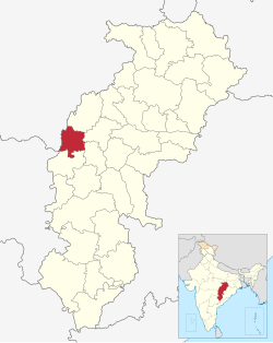
Rajnandgaon is a district of the state of Chhattisgarh in central India. The administrative headquarters the district is Rajnandgaon town.

<span class="mw-page-title-main">Gondia</span> City in Maharashtra, India

Gondia is a city and municipal council in the Indian state of Maharashtra which serves the administrative headquarters of the eponymous administrative district. Gondia is also known as Rice City due to the abundance of rice mills in the area. Gondia Airport is the only airport in the district.

Chhuikhadan is a City municipality and district in Khairagarh-Chhuikhadan-Gandai district in the Indian state of Chhattisgarh, India. Chhuikhadan is also known as "city of martyr".

<span class="mw-page-title-main">Gandai-Pandaria</span> Village town in Chhattisgarh, India

Gandai-Pandaria is a village town and a nagar panchayat in Chhuikhadan Block In the Khairagarh-Chhuikhadan-Gandai district in the state of Chhattisgarh, India. It is located about 80 kilometers northwest of Raipur, the state capital. Gandai is one of the centers of Gond people in contemporary times, particularly the kandra tribe.

<span class="mw-page-title-main">Dhamtari district</span> District of Chhattisgarh in India

Dhamtari is a district of the Indian state of Chhattisgarh. This district is situated at 20°42' N latitude and 81°33' E longitude. Dhamtari district was officially formed on 6 July 1998 by trifurcating Raipur district into Raipur, Dhamtari and Mahasamund districts.

<span class="mw-page-title-main">Kabirdham district</span> District of Chhattisgarh in India

Kabirdham district is one of the 33 administrative districts of Chhattisgarh state in central India. The district was earlier known as Kawardha district. The district is located between 21.32' to 22.28' north latitude and 80.48' to 81.48' east longitude. The district covers an area of 4,447.5 km2 (1,717.2 sq mi). The city of Kawardha is its administrative headquarters. This district is known for the Bhoramdeo temple located at a distance of 18 km from the district headquarters, Kawardha.

<span class="mw-page-title-main">Mahasamund district</span> District of Chhattisgarh in India

Mahasamund district is a district in Chhattisgarh state in central India. The city of Mahasamund is the district headquarters. The district is particularly famous for the historical temple town of Sirpur besides the Mahanadi river.

Bemetara is a municipality in Bemetara district of Indian state of Chhattisgarh.

<span class="mw-page-title-main">Bemetara district</span> District of Chhattisgarh in India

Bemetara district is a new district in the state of Chhattisgarh, India.

<span class="mw-page-title-main">Balrampur district, Chhattisgarh</span> District of Chhattisgarh in India

Balrampur-Ramanujganj district is a district in the Indian state of Chhattisgarh. It came into existence on 17 January 2012 and was formerly part of Surguja district. Balrampur-Ramanujganj district is the northernmost district of Chhattisgarh. Its seat is Balrampur.

Salhewara is the main village in Khairagarh-Chhuikhadan-Gandai district of the Indian state of Chhattisgarh. The population is about 5,000.

<span class="mw-page-title-main">Hemchand Yadav Vishwavidyalaya</span> University in Chhattisgarh, India

Hemchand Yadav Vishwavidyalaya or Hemchand Yadav University, formerly Durg Vishwavidyalaya, is a state university in Durg, Chhattisgarh, India. It was established in 2015 and later renamed in 2018.

References

  1. "Chhattisgarh: With new district promise, Cong wins Khairagarh by margin of 20,000 votes". The Indian Express . 2022-04-16. Retrieved 2022-07-19.
  2. "Table C-01 Population by Religion: Chhattisgarh". censusindia.gov.in. Registrar General and Census Commissioner of India. 2011.
  3. "District Census Handbook: Rajnandgaon" (PDF). censusindia.gov.in. Registrar General and Census Commissioner of India. 2011.
  4. 1 2 "Table C-16 Population by Mother Tongue: Chhattisgarh". www.censusindia.gov.in. Registrar General and Census Commissioner of India.