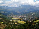
Bhimdatta, is a municipality in Kanchanpur District of Sudurpashchim Pradesh, Nepal. The city and the municipality were named Mahendranagar in the honour of late king Mahendra of Nepal. After becoming a republic in 2008, the Mahendranagar municipality name was changed to Bhimdatta municipality in honour of the revolutionary farmer leader Bhimdatta Panta. It is surrounded by Bedkot Municipality in the east, Dadeldhura District in the north, Shuklaphanta National Park in the south and Uttarakhand, India in the west.

Triyuga is one of eight municipalities of Udayapur district of the Province No. 1 of Nepal. Gaighat is the headquarter of the municipality. According to the 1991 Nepal census, it had a population of 55,291. According to the 2011 Nepal census, Triyuga had 87,557 inhabitants. It is divided into 16 wards. Triyuga Municipality was established on B.S. Chaitra 13, 2053. It was named after Triyuga River. A river which flows through the town. Triyuga is the 3rd largest municipality in Nepal and 1st largest in Province No. 1 in term of size (area). The total area of the municipality is 547.43 square kilometres (211.36 sq mi)

Bidur is the capital of Nuwakot District in Bagmati Province, Nepal. At the time of the 1991 Nepal census it had a population of 18694 and had 3736 houses in it.
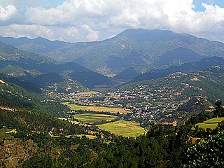
Sandhikharka Municipality is the headquarter of Arghakhanchi District which lies in Lumbini Province of Nepal. The former village development committee (VDC) was converted into a municipality on 18 May 2014 by merging the existing Sandhikharka, Wangla, Narapani, Khanchikot, Kimadada, Argha and Dibharna VDCs evdo. It is located, in a valley surrounded by hills, in the western part of the capital, Kathmandu.
The 1991 Nepal census was a widespread national census conducted by the Nepal Central Bureau of Statistics.
Adhikarichaur is a village development committee in Baglung District in the Dhaulagiri Zone of central Nepal. At the time of the 1991 Nepal census it had a population of 5,389 and had 1021 houses in the town. It contains the Shiba Primary School.
Narayansthan is a village development committee in Baglung District in the Dhaulagiri Zone of central Nepal.It is located above the bank of Kali gandaki River. Now, it has become one of the major important place in baglung. They have planned to construct the domestic Airport. At the time of the 2011 Nepal census it had a population of 2,876 and had 781 houses in the town. The major castes living in the VDC are Brahman, Chhetry and Newar. There are 2 high schools - Janatadhan Higher School and Ganesh Secondary School and one campus. Krishna Gandaki Campus is at the premises of Janatadhan HSS. Ganesh Secondary School, one of the best schools in the region is known for its quality education movement. Established in 1957 [2014 BS] by Soldier Board (India), Ganesh Secondary School is one of the oldest schools. In 1964 [2021 BS], the Indian Soldier Board stopped its grant. Since there was no school support mechanism developed from the Government of Nepal, the school passed through many ups and downs. After Modern Education Act came in effect in 1971 BS [2028 BS], the school merged with Janatadhan Higher Secondary School. In 1980 [2037 BS], the school was reopened.
Martadi is a town and seat of Bajura District Coordination Committee. It is also the headquarters of the Badi Malika Municipality. At the time of the 1991 Nepal census it had a population of 4,618 and had 942 houses in the town but now it has increased by growth rate of 2.62 and reached 8807.

Naubasta is a town in Banke District in the Bheri Zone of south-western Nepal. At the time of the 1991 Nepal census it had a population of 11,160 and had 1663 houses in the town.
Padanaha is a village development committee in Bardiya District in Lumbini Province of south-western Nepal. At the time of the 1991 Nepal census it had a population of 7,186 and had 888 houses in the town.
Arupokhari (आरूपोखारी), also spelled Aarupokhari, is a village development committee in Gorkha District in the Gandaki Zone of northern-central Nepal. At the time of the 1991 Nepal census it had a population of 5,465 and had 898 houses in the town.

Takukot is a Ward of Barpak sulikot Rural Municipality in Gorkha District in the Gandaki Province of northern-central Nepal. At the time of the 1991 Nepal census it had a population of 4,234 and had 801 houses in the town.

Dhapakhel is a town in Lalitpur District in the Bagmati Zone of central Nepal. At the time of the 1991 Nepal census it had a population of 4591 in 857 individual households. At the eastern part of Dhapakhel the Kantipur Engineering College is located.
Wamitaksar (Nepali:वामीटक्सार) is a town and Village Development Committee in Gulmi District in the Lumbini Zone of central Nepal. At the time of the 1991 Nepal census it had a population of 6421. It is located 128.54 kilometers of the capital of Nepal Kathmandu.
Hemja is a former Village Development Committee in the north of Pokhara in Kaski District in the Gandaki Province of northern-central Nepal. In 2014, Hemja was annexed to Pokhara City as ward number 27.Hemja is now under Pokhara Municipality ward #25. At the time of the 2011 Nepal census, it had a population of 12,262 living in 3,019 households.
Mehelkuna is a village development committee in Surkhet District in the Bheri Zone of mid-western Nepal. At the time of the 1991 Nepal census it had a population of 7649 people living in 1404 individual households. Pavitra Bazzar is the largest town in this VDC. There are two Higher Secondary Schools.
Chhatiwan is a Village Development Committee in Doti District in the Seti Zone of western Nepal. At the time of the 1991 Nepal census it had a population of 3000 residing in 478 individual households. The name for this VDC comes from a lake that is situated in the village of Chhatiwan. This lake has fresh drinking water and teamed with various kind of fish. Lately due to the deforestation and soil erosion, this lake is being filled with all debris coming in due to the flash flood from its North side of the mountain. Budar is the major town of this VDC and at this town Dadeldhura and Jogbuda roads cross. Some of the major villages in this VDC are Budar, Ritha, Phaltude, Dharapani, Chhatiwan, Chhahara and many others. There are two small mountain streams that eventually meet up at Deujaal. A stream that comes from the Chhahara village has a wonderful water fall. The name of the water fall itself is Chhahara. In Nepali "Chhahara" means water fall. Once in a year there is a special festival at the foot of this water fall where people from many surrounding villages come and celebrate throughout the night. The festival begins in the evening and people sing, dance and merry all through the night. This is also the night when lovers elope if the family does not agree for their marriage. Along the stream grows a plant called "sisnu". This plant has mild poisonous element and once the Caterpillar type of hairy things get stuck in the skin, the skin will be burning for a long time. But the belief is that once in a year after the festival you have to be stung by that plant so that you will remain healthy throughout that year. So, people will be chasing each other in the morning to torture each other with that plant. Some times drinking creates big fights among the villager.
Chhatiwan VDC is also popular for a model school in far west Nepal. Rampur School is the oldest school and now it has school for the disabled children for the whole of Far west. There is also an Army School in Budar. During the construction of Dadeldhura Highway, Budar was very important place as it was the headquarters for the road construction department.
Bhiman is a town in Kamalamai Municipality Ward no. 11 in Sindhuli District in the Janakpur Zone of south-eastern Nepal. At the time of the 1991 Nepal census it had a population of 7609 people living in 1389 individual households.

Bhadrapur is a town and municipality in Jhapa District in the Mechi Zone of southeastern Nepal. It lies on the banks of the Mechi River, and shares borders with Bihar state, India on south and West Bengal state on north. There is a border crossing with customs office for goods. Galgalia village in Kishanganj District borders with Bhadrapur
Urlabari is a city and municipality in Morang District in the Koshi Zone of south-eastern Nepal. It is considered to be the second largest city in Morang District after Biratnagar. At the time of the 1991 Nepal census it had a population of 18,224. At the time of the 2011 Nepal census it had a population of 35,166 and 8,165 households.