Related Research Articles

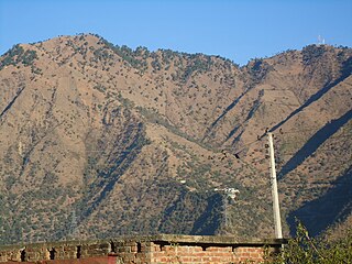
Himachal Pradesh is a state in the northern part of India. Situated in the Western Himalayas, it is one of the thirteen mountain states and is characterised by an extreme landscape featuring several peaks and extensive river systems. Himachal Pradesh is the northernmost state of India and shares borders with the union territories of Jammu and Kashmir and Ladakh to the north, and the states of Punjab to the west, Haryana to the southwest, Uttarakhand to the southeast and a very narrow border with Uttar Pradesh to the south. The state also shares an international border to the east with the Tibet Autonomous Region in China. Himachal Pradesh is also known as Dev Bhoomi or Dev Bhumi, meaning 'Land of Gods' and Veer Bhoomi which means 'Land of the Brave'.

Manali is a town, near Kullu town in Kullu district in the Indian state of Himachal Pradesh. It is situated in the northern end of the Kullu Valley, formed by the Beas River. The town is located in the Kullu district, approximately 270 kilometres (170 mi) north of the state capital of Shimla and 544 kilometres (338 mi) northeast of the national capital of New Delhi. With a population of 8,096 people recorded in the 2011 Indian census Manali is the beginning of an ancient trade route through Lahaul (H.P) and Ladakh, over the Karakoram Pass and onto Yarkand and Hotan in the Tarim Basin of China. Manali is a popular tourist destination in India and serves as the gateway to the Lahaul and Spiti district as well as the city of Leh in Ladakh.
Paonta Sahib is an industrial town of Himachal Pradesh in India. It is located in the south of Sirmaur district, on National Highway 72. Paonta Sahib is an important place of worship for Sikhs, hosting a large Gurdwara named Gurudwara Paonta Sahib, on the banks of the river Yamuna. The river is the boundary between the states of Himachal Pradesh and Uttarakhand.

The state of Himachal Pradesh is spread over an area 55,673 km2 (21,495 sq mi) and is bordered by Jammu and Kashmir and Ladakh on the north, Punjab on the southwest, Haryana on the south, Uttarakhand on the southeast, a small border with Uttar Pradesh in the south, and Tibet on the east. Entire Himachal Pradesh lies in the mountainous Himalaya region, rich in natural resources

Theog is a town and a municipal committee as well as a tehsil in Shimla district in the Indian state of Himachal Pradesh. It's just 30 km from state capital Shimla & 37 KM from ISBT Shimla. First settlements were in 1902.
Raison is a stopover which has vast camping grounds maintained by Himachal Pradesh Tourism.
Suketi is a village in Sirmaur District, Himachal Pradesh, India. It has Asia's oldest Fossil park Shivalik Fossil Park.

Kandaghat is a small town and tehsil (sub-district), near Solan city in the Solan district of Himachal Pradesh, India which is on the Kalka-Shimla National Highway No. 22. The road to the famous tourist destination of Chail turns from Kandaghat which is at a distance of 29 km. The capital of Himachal Pradesh, Shimla is at a distance of 30 km.

Nargu Wildlife Sanctuary lies on the east side of the Uhl River in Mandi District of Himachal Pradesh. It was notified in 1999 and covers an area of 132.37 km2 (51.11 sq mi). The slopes of the sanctuary are covered with Alpine forest. It is home to various species of animals and birds.
Inderkilla National Park is a national park in Himachal Pradesh, India established in 2010. It covers an area of about 104 square kilometres (40 sq mi). The national park is located in the Kullu district and 46.1 kilometers away from the Kullu Manali Airport.
Simbalbara National Park is a national park in India, located in the Paonta Valley of Sirmour District, Himachal Pradesh, along its border with Haryana. It is also known as Col. Sher Jung National Park. The vegetation consists of dense Sal forests with grassy glades. The protected area was created in 1958 as the Simbalbara Wildlife Sanctuary with 19.03 km². In 2010, 8.88 km² were added to it and it was made into a National Park, covering an area of about 27.88 square kilometres (10.76 sq mi). There is a perennial stream in the valley. The Travel and Tourism department of Himachal Pradesh has preserved the park in its natural form.

Lahaul and Spiti Assembly constituency is one of the 68 assembly constituencies of Himachal Pradesh a northern Indian state. Lahaul and Spiti is also part of Mandi Lok Sabha constituency.
Bhanauta is a village located in Chamba District, Himachal Pradesh. It is located 9 km (5.6 mi) towards north from District headquarters Chamba, 15 km (9.3 mi) from Chamba, 385.8 km (239.7 mi) from the state capital Shimla and 585.6 km (363.9 mi) from the national capital Delhi.
Dhan is a village in the Tehsil of Jawali, Himachal Pradesh in India. As of the 2011 census, the village had a population of 1,878 persons in 399 households. The chief elected official is a Sarpanch.

Fatehpur is one of the 68 constituencies in the Himachal Pradesh Legislative Assembly. It is a part of Kangra Lok Sabha constituency.
Manali Assembly constituency is one of the 68 constituencies in the Himachal Pradesh Legislative Assembly of Himachal Pradesh a northern state of India. Manali is also part of Mandi Lok Sabha constituency.
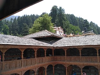
Naggar Castle is a medieval castle, located in Kullu, Himachal Pradesh, India. Built by Raja Sidh Singh of Kullu around 1460 A.D, it was taken over by the Himachal Pradesh Tourism Development Corporation (HPTDC), to run as a heritage hotel, in 1978.
Mount Friendship, also called Friendship Peak, is a mountain summit in Manali town of Kullu district of Himachal Pradesh, India on an altitude of 5,287 metres (17,346 ft) above sea level.
Kumarsain Assembly constituency was one of the 68 constituencies until 2008 delimitation in the Himachal Pradesh Legislative Assembly of Himachal Pradesh state in India. It was a segment of Simla Lok Sabha constituency. It included areas of Kumarsain tehsil and Sunni tehsil of Shimla district. Post 2008 delimitation, Kumarsain tehsil became part of Theog Assembly constituency and Sunni tehsil became part of Shimla Rural Assembly constituency.
Pragpur was one of the 68 constituencies in the Himachal Pradesh Legislative Assembly of Himachal Pradesh a northern state of India. It was in Kangra district and was a part of Kangra Lok Sabha constituency.
References
- ↑ "List of National Parks in Himachal Pradesh – updated". Abhinav Nature Conservation. Archived from the original on 28 September 2015. Retrieved 27 September 2015.
- ↑ Ashwani Sharma (9 December 2011). "Sanctuaries: Himachal gets a month to finalise draft". The Indian Express.
- ↑ "Khir Ganga and Great Himalayan National Park | Himachal Watcher". 7 July 2016. Retrieved 4 June 2021.
32°00′18″N77°39′58″E / 32.005°N 77.666°E
| | This Himachal Pradesh location article is a stub. You can help Wikipedia by expanding it. |
| | This article about protected areas of India is a stub. You can help Wikipedia by expanding it. |