Taurida Governorate was an administrative-territorial unit (guberniya) of the Russian Empire. It included the territory of the Crimean Peninsula and the mainland between the lower Dnieper River with the coasts of the Black Sea and Sea of Azov. It formed after Taurida Oblast was abolished in 1802 during the course of Paul I's administrative reform of the territories of the former Crimean Khanate which were annexed by Russia in 1783. The governorate's centre was the city of Simferopol. The name of the province was derived from Taurida, a historical name for Crimea.

Minsk Governorate was an administrative-territorial unit (guberniya) of the Russian Empire, with its capital in Minsk. It was created from the land acquired in the partitions of Poland and existed from 1793 until 1921. Its territory covered the majority of modern-day Belarus.

Kherson Governorate, known until 1803 as Nikolayev Governorate, was an administrative-territorial unit (guberniya) of the Russian Empire, with its capital in Kherson. It encompassed 71,936 square kilometres (27,775 sq mi) in area and had a population of 2,733,612 inhabitants. At the time of the census in 1897, it bordered Podolia Governorate to the northwest, Kiev Governorate to the north, Poltava Governorate to the northeast, Yekaterinoslav Governorate to the east, Taurida Governorate to the southeast, Black Sea to the south, and Bessarabia Governorate to the west. It roughly corresponds to what is now most of Mykolaiv, Kirovohrad and Odesa Oblasts in Ukraine and some parts of Kherson and Dnipropetrovsk Oblasts.

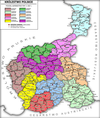
Congress Poland was subdivided several times from its creation in 1815 until its dissolution in 1918. Congress Poland was divided into departments, a relic from the times of the French-dominated Duchy of Warsaw. In 1816 the administrative divisions were changed to forms that were more traditionally Polish: voivodeships, obwóds and powiats. Following the November Uprising, the subdivisions were again changed in 1837 to bring the subdivisions closer to the structure of the Russian Empire when guberniyas (governorates) were introduced. In this way, Congress Poland was gradually transformed into the "Vistulan Country". Over the next several decades, various smaller reforms were carried out, either changing the smaller administrative units or merging/splitting various guberniyas.

Lublin Governorate was an administrative-territorial unit (guberniya) of Congress Poland of the Russian Empire.

Sandomierz Governorate was an administrative-territorial unit (guberniya) of Congress Poland of the Russian Empire.

Radom Governorate was an administrative-territorial unit (guberniya) of Congress Poland of the Russian Empire.

Piotrków Governorate was an administrative-territorial unit (guberniya) of Congress Poland of the Russian Empire, established in 1867 by splitting some areas of Radom and Warsaw Governorates. Its capital was in Petrokov (Piotrków Trybunalski).

Kholm Governorate was an administrative-territorial unit (guberniya) of the Russian Empire, with its capital in Kholm (Chełm).

Płock Governorate was an administrative-territorial unit (guberniya) of Congress Poland of the Russian Empire.

Warsaw Governorate was an administrative-territorial unit (guberniya) of Congress Poland of the Russian Empire.
Kraków Governorate was an administrative-territorial unit (guberniya) of Congress Poland of the Russian Empire.

Kalisz Governorate was an administrative-territorial unit (guberniya) of Congress Poland of the Russian Empire.

Siedlce Governorate was an administrative-territorial unit (guberniya) of Congress Poland of the Russian Empire.

Łomża Governorate was an administrative-territorial unit (guberniya) of Congress Poland of the Russian Empire, with its capital in Łomża.

Poltava Governorate was an administrative-territorial unit (guberniya) of the Russian Empire. It included the territory of left-bank Ukraine and was officially created in 1802 from the disbanded Little Russia Governorate, which was split between Chernigov and Poltava Governorates with its capital in Poltava.

Kharkov Governorate was an administrative-territorial unit (guberniya) of the Russian Empire founded in 1835. It embraced the historical region of Sloboda Ukraine. From 1765 to 1780 and from 1796 to 1835 the governorate was called Sloboda Ukraine Governorate. In 1780–1796 there existed the Kharkov Viceroyalty.

Volhynia Governorate, also known as Volyn Governorate, was an administrative-territorial unit (guberniya) of the Southwestern Krai of the Russian Empire. It consisted of an area of 71,736 square kilometres (27,697 sq mi) and a population of 2,989,482 inhabitants. The governorate bordered Grodno and Minsk Governorates to the north, Kiev Governorate to the east, Podolia Governorate to the south, Lublin and Siedlce Governorates, and after 1912, Kholm Governorate and Austria to the west. Its capital was in Novograd-Volynsky until 1804, and then Zhitomir. It corresponded to most of modern-day Volyn, Rivne and Zhytomyr Oblasts of Ukraine and some parts of Brest and Gomel Regions of Belarus.

Vologda Governorate, also known as the Government of Vologda, was an administrative-territorial unit (guberniya) of the Russian Empire and the Russian SFSR, which existed from 1796 until 1929. Its administrative center was in the city of Vologda.

Chernihiv Governorate was an administrative-territorial unit of the Ukrainian State and the Ukrainian SSR, existing from 1918 to 1925. It was inherited from the Russian system of territorial subdivisions that existed prior to World War I. Specifically, Chernigov Governorate was an administrative-territorial unit (guberniya) of the Russian Empire. It included the territory of the left-bank Ukraine and was officially created in 1802 from Malorossiya Governorate with its capital in Chernigov (Chernihiv). Little Russia Governorate was transformed into the General Government of Little Russia and consisted of Chernigov Governorate, Poltava Governorate, and later Kharkov Governorate.