Holla Bend National Wildlife Refuge is a 7,055 acre (28.6 km2) wildlife refuge located 5 miles south-east of Dardanelle, Arkansas.

The White River National Wildlife Refuge is a 160,756 acres (650.56 km2) wildlife refuge located in Desha, Monroe, Phillips, and Arkansas counties in the U.S. state of Arkansas. The refuge is managed by the United States Fish and Wildlife Service. White River NWR borders on Cache River National Wildlife Refuge at its northern boundary. In 1974, the White River Sugarberry Natural Area was designated as a National Natural Landmark by the National Park Service.

Gateway National Recreation Area is a 26,607-acre (10,767 ha) U.S. National Recreation Area in New York City and Monmouth County, New Jersey. It provides recreational opportunities that are not commonly found in a dense urban environment, including ocean swimming, bird watching, boating, hiking and camping. More than 8.7 million people visited Gateway National Recreation Area in 2022, making it the fourth-most visited unit of the National Park Service.

Finns Point is a small promontory in Pennsville Township, Salem County, New Jersey, and New Castle County, Delaware, located at the southwest corner of the cape of Penns Neck, on the east bank of the Delaware River near its mouth on Delaware Bay. Due to the wording of the original charter defining the boundaries of New Jersey and Delaware, part of the promontory is actually enclosed within the state of Delaware's border, due to tidal flow and the manner in which the borders between New Jersey and Delaware were first laid out. Therefore, this portion of Finns Point, also called The Baja, is an exclave of Delaware, cut off from the rest of the state by Delaware Bay. The area, the westernmost point in New Jersey, is about 10 miles (16 km) south of the city of Wilmington, and directly across the Delaware River from the New Castle area, and the Delaware River entrance to the Chesapeake & Delaware Canal. Pea Patch Island, part of the state of Delaware, sits in the channel of the river facing the promontory.
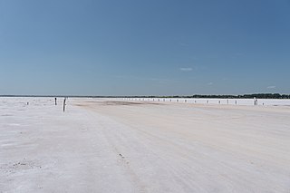
The Salt Plains National Wildlife Refuge is part of the United States system of national wildlife refuges. It is located in Alfalfa County in northern Oklahoma, north of Jet, along Great Salt Plains Lake, which is formed by a dam on the Salt Fork of the Arkansas River.

The Detroit River International Wildlife Refuge is the only international wildlife refuge in North America. Established in 2001 and managed jointly by the United States Fish and Wildlife Service and the Canadian Wildlife Service, it is located in a major metropolitan area. The Detroit River International Wildlife Refuge is one of over 540 National Wildlife Refuges managed by the U.S. Fish and Wildlife Service within the Department of the Interior. It occupies 7.88 square miles (20.41 km2) of scattered property but has drawn boundaries for further expansion.
The Charles M. Russell National Wildlife Refuge is a National Wildlife Refuge in the U.S. state of Montana on the Missouri River. The refuge surrounds Fort Peck Reservoir and is 915,814 acres (3,706.17 km2) in size. It is the second-largest National Wildlife Refuge in the lower 48 states of the United States, and the largest in Montana. Created in 1936, it was originally called the Fort Peck Game Range. It was renamed in 1963 after Montana artist Charles M. Russell, a famous painter of the American West. In 1976, the "range" was made a "refuge".

Boyer Chute National Wildlife Refuge, created in 1992, is a National Wildlife Refuge (NWR) located along the banks of the Missouri River in the U.S. state of Nebraska. The 4,040-acre (1,630 ha) refuge preserves an area that had been cultivated and neglected before the early 1990s. Channelization projects along the Missouri River to improve flood control and navigation resulted in the closing off a side branch of the river, known since the early 19th century as Boyer Chute. Between 1820 and 1937 the Missouri River had migrated 3 mi (4.8 km) eastward and the area of the chute had originally been on the east bank of the river; today, the chute is west of the main channel of the Missouri. In 1937, the Army Corps of Engineers began to rechannel portions of the Missouri River, cutting off the chute to flowing water. Overgrowth and cultivation took over the lands now preserved in the refuge. Restoration of the area commenced in 1993; this included planting 9,100 native plants and trees and restoring the inflow to the chute from the main channel of the Missouri River.
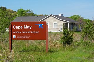
The Cape May National Wildlife Refuge is a protected area on the Cape May Peninsula in Cape May County, New Jersey. It is part of the National Wildlife Refuge System and managed by the United States Fish and Wildlife Service. Established in January 1989 with 90 acres (0.36 km2) acquired from the Nature Conservancy, it has since grown to more than 11,000 acres (45 km2) in size, and plans call for its further expansion to more than 21,200 acres (86 km2). It comprises three distinct and non-contiguous units: the Delaware Bay Division, the Great Cedar Swamp Division and the Two Mile Beach Unit. Located in the Middle Atlantic coastal forests ecoregion, the cape provides habitat for large numbers of migratory birds.

The Atlantic Flyway is a major north-south flyway for migratory birds in North America. The route generally starts in Greenland, then follows the Atlantic coast of Canada, then south down the Atlantic Coast of the United States to the tropical areas of South America and the Caribbean. Every year, migratory birds travel up and down this route following food sources, heading to breeding grounds, or traveling to overwintering sites.
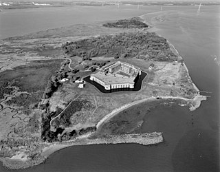
Fort Delaware State Park is a 288-acre (117 ha), 1 mi (1.6 km) long Delaware state park on Pea Patch Island in the mid channel of the Delaware River near its entrance into Delaware Bay. It is a low, marshy island in New Castle County, Delaware, facing Delaware City on the Delaware shore and Finns Point on the New Jersey shore. Fort Delaware was built on Pea Patch Island by the United States Army in 1815, near the conclusion of the War of 1812, to protect the harbors of Wilmington, Delaware and Philadelphia, Pennsylvania. The fort was burned and rebuilt in the years prior to the American Civil War, and soon after the start of the war the fort was converted to a Prisoner of War camp. Fort Delaware continued to protect the mouth of the Delaware River through World War I and II. Pea Patch Island and Fort Delaware was declared surplus land by the United States Department of Defense in 1945.

Wassaw Island is one of the Sea Islands. It is located on the Atlantic Ocean off the coast of the U.S. state of Georgia and is within the borders of Chatham County. The island and its surrounding marshlands are part of the Wassaw National Wildlife Refuge, which has a total area of 10,053 acres (40.68 km2) of marsh, mudflats, and tidal creeks, including approximately 7 miles (11 km) of undeveloped beaches. The land mass is 76 percent salt marshes and 24 percent beaches, dunes, and maritime forest. The refuge is a part of the Savannah Coastal Refuges Complex.

The Eastern Shore of Virginia National Wildlife Refuge is a 1,127-acre (4.56 km2) wildlife refuge located in Northampton County, Virginia, at the southern end of the Eastern Shore and near the tip of the Delmarva Peninsula. It is managed by the United States Fish and Wildlife Service.

Delaware State Park is a 1,686-acre (682 ha) public recreation area on U.S. Route 23 near the city of Delaware in Delaware County, Ohio, in the United States. It is open for year-round recreation including camping, hiking, boating, hunting, fishing, and picnicking.

John Redmond Reservoir is a reservoir on the Neosho River in eastern Kansas. Built and managed by the U.S. Army Corps of Engineers, it is used for flood control, recreation, water supply, and wildlife management. It borders the Flint Hills National Wildlife Refuge to the northwest.

The Assabet River National Wildlife Refuge is a 2,230-acre (9.0 km2) protected National Wildlife Refuge located approximately 25 miles (40 km) west of Boston and 4 miles (6.4 km) west of the Eastern Massachusetts National Wildlife Refuge Complex Headquarters, along the Assabet River. It is located in portions of the towns of Hudson, Maynard, Stow and Sudbury. The Assabet River National Wildlife Refuge consists of two separate pieces of land. The larger northern section is just north of Hudson Road, extending north to the Assabet River. The southern section is located to the south of Hudson Road. There is a visitor center located in the northern section on Winterberry Way.

Oxbow National Wildlife Refuge is a property of the United States National Wildlife Refuge (NWR) system located in Middlesex and Worcester counties in Massachusetts. It was founded in 1974.
The Great River National Wildlife Refuge protects approximately 11,600 acres (47 km2) along 120 miles (190 km) of the Mississippi River, stretching north of St. Louis, Missouri. Three separate units are located in the floodplain, on both the Illinois and Missouri sides of the river.

The Supawna Meadows National Wildlife Refuge is a component of the Delaware River estuary in Salem County, New Jersey, it is just north of the Salem River and south of Pennsville.
Tybee National Wildlife Refuge was established on May 9, 1938, by an executive order of President Franklin D. Roosevelt, as a breeding area for migratory birds and other wildlife. Located in the mouth of the Savannah River, the 100-acre (0.40 km2) refuge began as a 1-acre (4,000 m2) oyster shoal, Oysterbed Island, used by the U.S. Army Corps of Engineers as a spoil disposal site to support their mandated harbor dredging activity. As a result, the majority of the refuge is now covered with sand deposits. The more stable portions of the island are densely covered with such woody species as eastern red cedar, wax myrtle, and groundsel. Saltwater marsh borders parts of the island.
