
Greencastle is a hamlet in County Tyrone, Northern Ireland. It is within the townland of Sheskinshule.

Monknewtown, historically called Rathenskin, is a townland 3 km east of Slane in County Meath, Ireland. It stands on the right bank of the Mattock River, which feeds several historic watermills nearby and which forms approximately the townland's eastern boundary with Keerhan and Sheepgrange townlands in County Louth. Neighbouring townlands to the south are Balfeddock, Knowth, and Crewbane, to the west Cashel, Mooretown, and Knockmooney. The northern boundary of Monknewtown with Kellystown is formed by a tributary of the Mattock River, while the southern boundary is formed by the N51 road. Other than the latter, only minor roads traverse the townland, among them L5606 from west to east.

Williamstown is a small village located on the R360 regional road in the townland of Corralough in northeast County Galway, Ireland. According to the census in April 2016, the population of the village was 148.
The R154 road is a regional road in Ireland, linking the R147 near Clonee, County Meath to Crossdoney in County Cavan. The road is single carriageway throughout. Many parts of the route have dangerous bends.

Moylagh is a civil parish and townland in the northwest of County Meath, Ireland. The townland Moylagh lies within the Roman Catholic parish of Oldcastle and Moylagh.

Brackaville or Bracaville is a village and townland near Coalisland in County Tyrone, Northern Ireland. It is situated in the historic barony of Dungannon Middle and the civil parish of Donaghenry and covers an area of 235 acres on the western side of Lough Neagh.
The Loup is a small village in County Londonderry, Northern Ireland. It lies near the western shore of Lough Neagh between Moneymore, Magherafelt, Ballyronan and Coagh, within the district of Mid Ulster.

Carnteel ) is a hamlet, townland and civil parish, about 2 miles northeast of Aughnacloy in County Tyrone, Northern Ireland. It is situated in the historic barony of Dungannon Lower.

Kinsealy is an outer suburb of Dublin in Fingal, Ireland. Kinsealy is on the northside of the city, about 7 km from the centre city, on the Malahide Road, in the former green belt between the suburbs of Balgriffin, Portmarnock and Malahide.

Tubber is a village in the north of County Clare, Ireland.
Colehill is a village and townland in south-east County Longford, Ireland. Its Irish name was historically anglicised as Knocknagoal and Knocknagole.
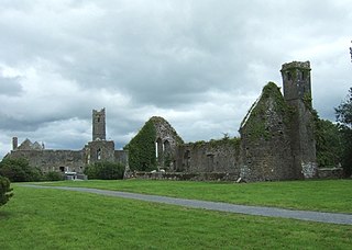
Quin is a village in southeast County Clare, Ireland. The name also refers to a civil parish in the barony of Bunratty Upper, and to an ecclesiastical parish of the same name. The main attraction in the vicinity is Quin Abbey, the ruins of Franciscan friary, which is open to the public. Although roofless, much of the structure remains and is relatively well-preserved. The abbey was built on the foundations of an earlier Norman castle; the foundations of three corner towers can still be seen.

Carrickfergus is a barony in County Antrim, Northern Ireland. It is bounded on the south-east by Belfast Lough, and otherwise surrounded by the barony of Belfast Lower. It is coextensive with the civil parish of Carrickfergus or St Nicholas and corresponds to the former county of the town of Carrickfergus, a county corporate encompassing Carrickfergus town.

Carrigan is a townland in the Parish of Tomregan, Barony of Loughtee Lower, County Cavan, Ireland.

Cloonbonniffe, officially Cloonbonniff, is a small village and townland in County Roscommon, Ireland. The nearest town is Castlerea, about eight kilometres east.
Poppintree, is a neighbourhood of the large outer suburb of Ballymun, Dublin, Ireland. It is bordered by Glasnevin and Finglas. The area includes Poppintree Park. the Poppintree Sports and Community Complex

Magheracross is a townland and civil parish in County Fermanagh, Northern Ireland. It extends in area from just north of Enniskillen to the border with County Tyrone. There is also a small enclave in County Tyrone.

Oldbridge is a townland near Drogheda in County Meath, Ireland. The area is home to the Boyne Navigation, the Battle of the Boyne Interpretive Centre and the southern half of the Mary McAleese Boyne Valley Bridge.
Cloghran is a civil parish in the ancient barony of Coolock in Ireland. It consists of eight townlands: Baskin, Cloghran, Clonshagh, Corballis, Middletown, Springhill, Stockhole, Toberbunny. According to Lewis' 1837 survey,
"Limestone abounds, and near the church is a quarry in which various fossils are found; under this quarry are copper and lead ores, but neither has yet been profitably worked. Baskin Hill, the seat of J. Tymons, Esq., was built by the present Bishop of Dromore, who resided there while rector of St. Doulough's ; and Castle Moat, the seat of J. Mac Owen, Esq., takes its name from an extensive moat, or rath, within the demesne, from which is a fine view of the country towards the village of the Man-of-War and the sea, including Lambay Island, Ireland's Eye, Howth, and the Dublin and Wicklow mountains.".
Gibbonstown is a townland in County Westmeath, Ireland. The townland is located in the civil parish of Kilbride. The R400 regional road runs to the west of the area. The townland of Fearmore lies to the south, Gaulstown and Whitewell to the west, and the town of Rochfortbridge to the south.

