The Walls of Jerusalem National Park is a national park located in the Central Highlands region of Tasmania, Australia. The park is located approximately 144 km (89 mi) northwest of Hobart, east of the Cradle Mountain-Lake St Clair National Park, and west of the Central Plateau Conservation Area. It is south of Mole Creek, Tasmania, and Rowallan Lake. The national park forms part of the Tasmanian Wilderness World Heritage Area.

Launceston is a city in the north of Tasmania, Australia, at the junction of the North Esk and South Esk rivers where they become the Tamar River (kanamaluka). With a population of 87,328, Launceston is the second most populous city in Tasmania after the state capital, Hobart, and the fifth-largest inland city in Australia.

Lake St Clair or leeawulenna is a natural freshwater lake located in the Central Highlands area of Tasmania, Australia. The lake forms the southern end of the Cradle Mountain-Lake St Clair National Park. It has an area of approximately 45 square kilometres (17 sq mi), and a maximum depth of 160 metres (520 ft), making it Australia's deepest lake.

Beaconsfield is a former gold mining town near the Tamar River, in the north-east of Tasmania, Australia. It lies 40 kilometres north of Launceston on the West Tamar Highway. It is a rural and residential locality in the local government areas (LGA) of West Tamar and Latrobe in the Launceston and North-west and west LGA regions of Tasmania. The 2016 census has a population of 1298 for the state suburb of Beaconsfield.

St Helens is the largest town on the north-east coast of Tasmania, Australia, on Georges Bay. It is known as the game fishing capital of Tasmania and is also renowned for its oysters. It is located on the Tasman Highway, about 160 km east of Tasmania's second largest city, Launceston. In the early 2000s, the town was one of the fastest growing areas of Tasmania, and reached a population of 2049 at the 2006 census. St Helens is part of the Break O'Day Council, a council that includes the nearby town of Binalong Bay. St Helens has also got its own Radio Station named Star FM a community station on 93.7 MHz in the town, 100.3 MHz in St Marys and 98.5 MHz in Bicheno. A number of shops can be found in the town along Cecilia Street, such as a Supa IGA and Gallery Parnella.

The Nahe is a river in Rhineland-Palatinate and Saarland, Germany, a left tributary to the Rhine. It has also given name to the wine region Nahe situated around it.

Mount Buninyong is an extinct volcano in western Victoria, Australia rising to 745 metres (2,444 ft) AHD. It lies within the Mount Buninyong Scenic Reserve, 4 kilometres (2.5 mi) north of the town of Buninyong and 14 kilometres (8.7 mi) south of Ballarat, on the regional city's rural-urban fringe.

Sheffield is a town 23 kilometres inland from Devonport on the north-west coast of Tasmania. Sheffield has long been the rural hub for the Mount Roland area. The Sheffield area is well known for its high quality butterfat production via dairy farming. The area is suitable for lamb and beef production. The town of Railton is nearby. At the 2016 census, Sheffield had a population of 1,552.

The Australian Maritime College (AMC) is a tertiary education institution based in Launceston, Tasmania, established by the Maritime College Act 1978 (Cth). Tertiary education is provided and organised by the University of Tasmania (UTAS) as the Australian Maritime College at the University of Tasmania (AMC@UTAS). However the college's educational curriculum is governed by the independent AMC Board. The AMC is Australia's national centre for maritime education, training and research. It has two campuses located within 50 kilometres (31 mi) of each other in Northern Tasmania, each with different facilities and residence.
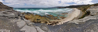
The South Coast Track is a bushwalking track located in the South Coast region of Tasmania, Australia. The 85-kilometre (53 mi) track traverses remote wilderness within the Southwest National Park, part of the Tasmanian Wilderness World Heritage Site, and is managed as a wilderness walk. The Tasmanian Parks & Wildlife Service recommend that experienced bushwalkers can take six-to-eight days to cover the track in one direction.

Bathurst Harbour is a shallow bay located in the south west region of Tasmania, Australia. Bathurst Harbour is contained within the Port Davey/Bathurst Harbour Marine Nature Reserve, and the Southwest National Park, part of the Tasmanian Wilderness World Heritage Area.
Port Davey is an oceanic inlet located in the south west region of Tasmania, Australia.
The Dial Range is a small mountain range in northwest Tasmania, south of the town of Penguin near the coast. It extends about 14 km (9 mi) north to south and 4-5 km west to east. It is bordered on the east and south by the Leven River, with the Gunns Plains to the south.

Quamby Bluff is a mountain in Northern Tasmania, Australia that is an outlying part of the Great Western Tiers mountain range.

The Gordon Dam, also known as the Gordon River Dam, is a major gated double curvature concrete arch dam with a controlled spillway across the Gordon River, located in South West Tasmania, Australia. The impounded reservoir is called Lake Gordon.
The Port Davey Track, officially the Old Port Davey Track, is a bushwalking track located in the south western region of Tasmania, Australia. The 70-kilometre (43 mi) track traverses remote wilderness within the Southwest National Park, part of the Tasmanian Wilderness World Heritage Site, and is managed as a wilderness walk. The Tasmanian Parks & Wildlife Service recommend that experienced bushwalkers can take four-to-five days to cover the track in one direction.

Lake Kununurra is a freshwater man-made reservoir located in the Ord River valley. The lake was formed in 1963 by the construction of the Ord Diversion Dam in Kununurra, northern Western Australia, which was built to supply water to the Ord River Irrigation Area. Prior to the diversion dam construction a natural permanent waterhole held back by the Bandicoot Bar was known as "Carlton Reach", which was reputed to be the largest waterhole in the Kimberley.
Kimberley is a rural locality and town in the local government areas of Meander Valley and Kentish in the Launceston and North-west and west regions of Tasmania. The locality is about 39 kilometres (24 mi) north-west of the town of Westbury. The 2016 census has a population of 149 for the state suburb of Kimberley. It is about midway between the towns of Sheffield and Deloraine. Once a thriving village with a school, railway station, shops and two churches, and is now a collection of houses with one church remaining.
The Frankland River is a major perennial river located in the north-west region of Tasmania, Australia.
The Supply River is a perennial river located in the northern region of Tasmania, Australia.
