
The London Borough of Islington is a London borough in Inner London. The borough includes a significant area to the south which forms part of central London. Islington has an estimated population of 215,667. It was formed in 1965 under the London Government Act 1963, which simultaneously abolished the metropolitan boroughs of Islington and Finsbury.

Clerkenwell is an area of central London, England.

Islington is a district in Greater London, England, and part of the London Borough of Islington. It is a mainly residential district of Inner London, extending from Islington's High Street to Highbury Fields, encompassing the area around the busy High Street, Upper Street, Essex Road, and Southgate Road to the east.

Pentonville Road is a road in Central London that runs west to east from Kings Cross to City Road at The Angel, Islington. The road is part of the London Inner Ring Road and part of the boundary of the London congestion charge zone.

Old Street is a 1-mile (1.6 km) street in inner north-east Central London that runs west to east from Goswell Road in Clerkenwell, in the London Borough of Islington, via St Luke's and Old Street Roundabout, to the crossroads where it meets Shoreditch High Street (south), Kingsland Road (north) and Hackney Road (east) in Shoreditch in the London Borough of Hackney.

The New River is an artificial waterway in England, opened in 1613 to supply London with fresh drinking water taken from the River Lea and from Chadwell Springs and, originally, Amwell Springs, as well as other springs and wells along its course.

Archway is an area of north London, England, within the London Borough of Islington. It is located 3.8 miles (6 km) north of Charing Cross. It is identified as a district centre in the London Plan, and is surrounded by mixed-density residential development. It straddles the A1 in London and is named after an erstwhile local landmark, the high, single-arched Archway Bridge which crossed the road in a cutting to the north. It has a modern commercial hub around Vantage Point and Archway tube station.

Liverpool Road is a street in Islington, North London. It covers a distance of 1+1⁄4 miles (2.0 km) between Islington High Street and Holloway Road, running roughly parallel to Upper Street through the area of Barnsbury. It contains several attractive terraces of Georgian houses and Victorian villas, many of which are listed buildings. There are a number of pubs, small businesses and restaurants along its route, as well as some secluded garden squares. The vast majority of the street is residential, with a bustling shopping and business area at the southern, Angel, end.
The WC postcode area, also known as the London WC postcode area, is a group of postcode districts in central London, England. The area covered is of high density development, and includes parts of the City of Westminster and the London Boroughs of Camden and Islington, plus a very small part of the City of London.

Goswell Road, in Central London, is an end part of the A1. The southern part ends with one block, on the east side, in City of London; the rest is in the London Borough of Islington, the north end being Angel. It crosses Old Street/Clerkenwell Road. In the north it splits Clerkenwell from Finsbury; the south was sometimes used as a demarcator but all but the southern corporate/legal/financial end in the modern era forms the heart of the highly developed mixed-use district Barbican.

The London Borough of Islington is short of large parks and open spaces, given its status in recent decades as a desirable place of residence. In fact, Islington has the lowest ratio of open space to built-up areas of any London borough. The largest continuous open space in the borough, at 11.75 hectares, is Highbury Fields.

Northampton Square, a green town square, is in a corner of Clerkenwell projecting into Finsbury, in Central London. It is between Goswell Road and St John Street, has a very broad pedestrian walkway on the north-west side between university buildings and is fronted chiefly by main buildings of City, University of London.

Caledonian Road passes for about a mile and a half north–south through the London Borough of Islington. It connects North London, from Camden Road near its junction with Holloway Road, and central London's Pentonville Road in the south. It is known colloquially as the "Cally" and forms the entirety of the A5203.

London Buses route 277 is a Transport for London contracted bus route in London, England. Running between Crossharbour and Dalston Junction, it is operated by Stagecoach London.

Holborn and Covent Garden is a ward of the London borough of Camden, in the United Kingdom. As the name suggests, it covers the parts of Holborn and Covent Garden that lie in Camden; the eastern part of Holborn lies in the City of London and the southern part of Covent Garden lies in the City of Westminster. For elections to Parliament, Holborn and Covent Garden is part of Holborn and St Pancras.

King's Cross is a ward of the London borough of Camden, in the United Kingdom. The ward has existed since the creation of the borough on 1 April 1965 and was first used in the 1964 elections. The population of the ward at the 2011 Census was 11,843.

Angel is an area on the northern fringes of central London within the London Borough of Islington. It is 2 miles (3.2 km) north-northeast of Charing Cross on the Inner Ring Road at a busy transport intersection. The area is identified in the London Plan as one of 35 major centres in London. It is a significant commercial and retail centre, and a business improvement district. It is named after the former Angel Inn which stood on the corner of Islington High Street and Pentonville Road.

Clerkenwell Road is a street in London.

King Square is a square in central London, in the St Luke's area of the London Borough of Islington. It is at the corner of Lever Street and Central Street, and shares in King Square Gardens to the west.
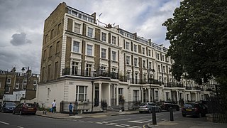
Arundel Square is a garden square in Barnsbury, North London. It is bounded on three sides by terraces of Victorian houses, and on the fourth with modern flats. The central public gardens contain mature trees, attractive flower beds and playground equipment.
