Kings Square, Fremantle

Last updated

A rally at Walyalup Koort. WTF Marlene Oostryck Rally in Kings Square.jpg
A rally at Walyalup Koort.
Kings Square, Fremantle
Walyalup Koort is near the centre of Fremantle.

Walyalup Koort, formerly known as Kings Square (or King's Square), is a town square in Fremantle, Western Australia. It is bounded by Queen, Newman, William, and Adelaide Streets. Though the square was originally a public reserve, it has been the site of Saint John's Church of England since 1843, and the Fremantle Town Hall since 1887. High Street was extended through and beyond the square in the 1880s, but the portion through the square was closed off in the 1960s. Today Kings Square functions as a civic and cultural centre of Fremantle, with modern events taking place adjacent to the historic buildings.

Contents

History

A Murray Views postcard, No 15, showing Fremantle's High Street, Central Buildings and the Town Hall; taken from near St John's Anglican Church. This section of High Street was later closed to traffic and incorporated into the then Kings Square. Fremantle High Street 1940s.jpg
A Murray Views postcard, No 15, showing Fremantle's High Street, Central Buildings and the Town Hall; taken from near St John's Anglican Church. This section of High Street was later closed to traffic and incorporated into the then Kings Square.

The square began as an open space [1] [2] [3] on John Septimus Roe's original town plan of Fremantle, drawn in 1833. [1] In 1839, property owners around the square petitioned the State Governor for a church to be built in the square. [2] This was approved in 1840, [2] and construction works began with the foundation stone being laid on 6 April 1842. [3] [4] Saint John's Church of England opened on 4 August 1843, [5] [6] and was consecrated on 16 November 1848. [6]

In 1876, the church applied to the Fremantle City Council for a strip of land, adjacent to the church wall, to be granted to the Church of England, for the purpose of building a new church on the site and to improve the amenity of Kings Square. [7] In this application, all of the land in Kings Square was claimed to have been previously granted to the Church of England, [7] though in later years this was seen to be controversial. [2] [3] [8] This application was refused, as the strip was used for storing and preparing stone (for use in road works), and some councillors believed the church had enough land already. [7] One year later, the church made a second proposal, offering the council the south-western corner of the square, and a right of way for the extension of High Street through the square, in return for the strip of land and 500 pounds. [9] The council accepted, subject to minor modification. [9]

The new church was constructed and consecrated in 1882. [10] It was funded in part by sale of the south-western corner to the Fremantle Council, and the sale of south-eastern portion, which was divided into lots. [8] [10] The council constructed the Fremantle Town Hall on the site it had purchased, between 1885 [11] and 1887, [12] [13] whilst private enterprises constructed buildings in the south east of the square during the 1880s. [8] These building were later demolished in 1929 to make room for an extension to the town hall. [8] In 1881, High Street was extended along the right of way through Kings Square. [14]

In the 1960s, Kings Square was reinstated as a town square with the closure of High Street, between Queen Street, at the eastern edge of the square, and Market Street, 100 metres (330 ft) [15] west of the square. [2] This was carried out as part of a traffic management plan for Fremantle, which included turning the streets around the square into a one way rotary. [2]

In July 2021, the name Kings Square was formally changed to Walyalup Koort following approval of the new name by the Minister for Lands. [16] The new name, which means 'Heart of Fremantle' in the local Whadjuk Nyoongar language, was selected by Fremantle Council in June 2021 following a community engagement process. [17] The name changed occurred despite community opposition and a written submission from Fremantle History Society stating that they did not support the renaming of this historical site. [18]

Current usage

People playing ping-pong at Walyalup Koort. WTF Marlene Oostryck Pinpong in Kings Square.jpg
People playing ping-pong at Walyalup Koort.

Walyalup Koort is now a paved and landscaped civic centre of Fremantle. [19] As well as the church and town hall, the square also features a giant chess board, various public artworks, and facilities such as toilets, [20] seating, and children's play equipment. [19] Cultural events take place in the square, including movie, music, and arts festivals, [21] [22] [23] [24] [25] [26] as well as group activities such as yoga [27] and drum circles. [28]

Public artworks and statues on display in Walyalup Koort include: [29]

Related Research Articles

<span class="mw-page-title-main">Perth</span> Capital city of Western Australia

Perth is the capital and largest city of the Australian state of Western Australia. It is the fourth most populous city in Australia and Oceania, with a population of 2.1 million living in Greater Perth in 2020. Perth is part of the South West Land Division of Western Australia, with most of the metropolitan area on the Swan Coastal Plain between the Indian Ocean and the Darling Scarp. The city has expanded outward from the original British settlements on the Swan River, upon which the city's central business district and port of Fremantle are situated. Perth is located on the traditional lands of the Whadjuk Noongar people, where Aboriginal Australians have lived for at least 45,000 years.

<span class="mw-page-title-main">Fremantle</span> Port city in Western Australia

Fremantle is a port city in Western Australia, located at the mouth of the Swan River in the metropolitan area of Perth, the state capital. Fremantle Harbour serves as the port of Perth. The Western Australian vernacular diminutive for Fremantle is Freo.

<span class="mw-page-title-main">Subiaco, Western Australia</span> Suburb of Perth, Western Australia

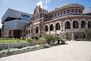
Subiaco is an inner-western suburb of Perth, the capital of Western Australia. It is approximately 3 km (1.9 mi) west of Perth's central business district, in the City of Subiaco local government area. Historically a working-class suburb containing a mixture of industrial and commercial land uses, since the 1990s the area has been one of Australia's most celebrated urban redevelopment projects. It remains a predominantly low-rise, urban village neighbourhood centred around Subiaco train station and Rokeby Road.

<span class="mw-page-title-main">Round House (Western Australia)</span> Former gaol in Fremantle, Western Australia

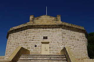
The Round House was the first permanent building built in the Swan River Colony. Built in late 1830 and opened in 1831, it is the oldest building still standing in Western Australia.

<span class="mw-page-title-main">City of Subiaco</span> Local government area in Western Australia

The City of Subiaco is a local government area in Western Australia. It covers an area of approximately 7 km² in inner western metropolitan Perth and lies about 3 km west of the Perth CBD. The City includes the historically working-class suburb of Subiaco centred around Rokeby Road. Since the 1990s the area has been extensively redeveloped and gentrified.

<span class="mw-page-title-main">Fremantle Town Hall</span> Town hall in Fremantle, Western Australia

Fremantle Town Hall is a town hall located in the portside city of Fremantle, Western Australia, and situated on the corner of High, William and Adelaide Streets. The official opening, on 22 June 1887, coincided with the celebration of Queen Victoria's Jubilee and it was formally named by the mayor, Daniel Keen Congdon and the state governor, Frederick Broome, as the Town and Jubilee Hall.

<span class="mw-page-title-main">Queen Victoria Street, Fremantle</span> Road in Fremantle, Western Australia

Queen Victoria Street is the main road entering the city centre of Fremantle, Western Australia from the direction of Perth. The road was originally named Cantonment Road, but was subsequently renamed Victoria Road, and a few years later Queen Victoria Street, after Queen Victoria of the United Kingdom, to avoid confusion with similarly named roads in the area.

<span class="mw-page-title-main">City of Fremantle</span> Local government area in Western Australia

The City of Fremantle is a local government area in the south of Perth, Western Australia. The City covers an area of 19.0 square kilometres (7.3 sq mi), and lies about 19 kilometres (12 mi) southwest of the Perth central business district.

<span class="mw-page-title-main">Trams in Fremantle</span> Tram network in Fremantle, Western Australia

The Fremantle tramway network linked the central business district of Fremantle, the port city for Perth, Western Australia, with nearby suburbs. Small but comprehensive, it operated between 1905 and 1952. It was not connected with the larger Perth tramway system.

Perth City Link is an urban renewal and redevelopment project in Perth, Western Australia.

<span class="mw-page-title-main">Tourism in Perth</span> Tourism in Perth

Tourism in Perth, the capital city of Western Australia, is an important part of the Australian state's economy, contributing to the prosperity of businesses in the city, as well as other regions of the state.

<span class="mw-page-title-main">High Street, Fremantle</span> Street in Fremantle, Western Australia

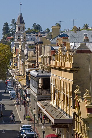
High Street is the main street running through the City of Fremantle, Western Australia. The street passes by historic landmarks, including the Round House, the Fremantle Town Hall, and the Fremantle War Memorial, through the Fremantle West End Heritage area and through two town squares. Trams operated along High Street for 47 years, between 1905 and 1952. Running east–west, High Street continues as Leach Highway, a major arterial road, at Stirling Highway, linking Fremantle with Perth Airport although the stretch of road between Stirling Highway and Carrington Street is known locally—and signed—as High Street.

<span class="mw-page-title-main">Queen Street, Fremantle</span> Street in Fremantle, Western Australia

Queen Street is a street in Fremantle, Western Australia that crosses High Street at Kings Square, and is located away from and west of Queens Square. It is a separate street from Queen Victoria Street, which is located 500 metres (0.3 mi) further north. The street is named after Queen Adelaide, consort of William IV.

<span class="mw-page-title-main">1919 Fremantle Wharf riot</span> Workers strike at Fremantle Harbour

The 1919 Fremantle Wharf riot, also known as the Battle of the Barricades, arose out of a strike by stevedores in Fremantle, Western Australia in 1919. The strike was called by the Waterside Workers' Federation (WWF) over the use of National Waterside Workers Union (NWWU) workers to unload the quarantined ship Dimboola, and escalated into fatal violence when WWF workers and supporters attempted to prevent NWWU members from carrying out the work.

Queens Square, also known as Queen's Square, is a town square in Fremantle, Western Australia. It is located at the intersection of High Street and Parry Street, both of which bisect the square. The square was originally a single space, but was divided into four sections due to the extensions of High and Parry Streets, completed in 1886. Today Queens Square still functions as a public open space for residents of Fremantle.

<span class="mw-page-title-main">St John's Anglican Church, Fremantle</span> Church in Fremantle, Western Australia

St John's Anglican Church also known as St John the Evangelist Church, is the historic Anglican parish church of Fremantle, Western Australia. The first Georgian-style church close to the present site was opened in 1843, and then replaced with a larger Gothic building nearby in 1882. The older building was demolished, which allowed Fremantle Town Hall to be built and for the High Street to be extended, giving the Kings Square its current shape.

<span class="mw-page-title-main">National Hotel (Fremantle)</span> Building in Fremantle, Western Australia

The National Hotel is on the corner of High and Market Streets Fremantle. Originally built as a shop in 1868, it was occupied by the National Bank in the early 1880s. When the bank relocated in 1886, the building became the National Hotel.

<span class="mw-page-title-main">Scots Presbyterian Church, Fremantle</span> Church in Western Australia

Scots Presbyterian Church is a Presbyterian church located at 90 South Terrace, on the corner of Parry Street, in Fremantle, Western Australia. It was the first Presbyterian Church built in Fremantle and one of only six to decline amalgamation with the Uniting Church.

<span class="mw-page-title-main">Wilhelmsen House</span> Heritage building in Fremantle, Western Australia

Wilhemsen House, also known as the Elders Building, Elder Building, Barwil House and the Dalgety & Co. Building, is a heritage building located at 11 Cliff Street on the corner of Phillimore Street in the port city of Fremantle, Western Australia. The building dates from the gold rush boom period in the late nineteenth and early twentieth centuries and is of historic significance.

The City of Fremantle Centenary Building was built by the Fremantle Council for the Centenary of Western Australia in 1929. It provided extra reception and office space for the council, the Federal Electoral Department, Tramway Board, and Water Supply Receiving Department) as well as other tenants, and improved public toilets.

References

  1. 1 2 "Statement of Significance". King's Square. State Heritage Office. Government of Western Australia. 23 December 2011. Retrieved 16 November 2012.
  2. 1 2 3 4 5 6 Ewers, John K. (1971). The Western Gateway: A History of Fremantle (2nd ed.). Nedlands, Western Australia: University of Western Australia Press for the Fremantle City Council. pp. 30, 184. ISBN   085564-050-2.
  3. 1 2 3 "OLD FREMANTLE". Western Mail . Perth. 21 April 1927. p. 29. Retrieved 18 November 2012 via National Library of Australia.
  4. "HISTORY OF FREMANTLE". The West Australian . Perth. 4 June 1929. p. 18. Retrieved 18 November 2012 via National Library of Australia.
  5. "OPENING OF THE CHURCH AT FREMANTLE". The Inquirer . Perth. 9 August 1843. p. 3. Retrieved 18 November 2012 via National Library of Australia.
  6. 1 2 "NEWS AND NOTES". The West Australian . Perth. 18 November 1913. p. 6. Retrieved 18 November 2012 via National Library of Australia.
  7. 1 2 3 "PREMANTLE—PORT COUNCIL". The Western Australian Times . Perth. 4 August 1876. p. 2. Retrieved 18 November 2012 via National Library of Australia.
  8. 1 2 3 4 "AN HISTORIC SITE". The West Australian . Perth. 24 May 1929. p. 18. Retrieved 18 November 2012 via National Library of Australia.
  9. 1 2 "MUNICIPAL MEETING". The Western Australian Times . Perth. 19 June 1877. p. 2. Retrieved 18 November 2012 via National Library of Australia.
  10. 1 2 "ST. JOHN'S CHURCH, FREMANTLE". Western Mail . Perth. 27 March 1914. p. 33. Retrieved 19 November 2012 via National Library of Australia.
  11. "NEWS OF THE WEEK". The West Australian . Perth. 27 June 1885. p. 6. Retrieved 19 November 2012 via National Library of Australia.
  12. "General News". The Inquirer & Commercial News (Perth, WA : 1855–1901) . Perth. 16 March 1887. p. 3. Retrieved 19 November 2012 via National Library of Australia.
  13. "JUBILEE DAY". The Inquirer & Commercial News (Perth, WA : 1855–1901) . Perth. 29 June 1887. p. 2. Retrieved 19 November 2012 via National Library of Australia.
  14. "High St. marches with history". The Sunday Times . Perth. 21 March 1954. p. 19 Section: FIRST SECTION. Retrieved 19 November 2012 via National Library of Australia.
  15. Google (17 November 2012). "Walking directions Market Street to Adelaide Street" (Map). Google Maps . Google. Retrieved 17 November 2012.
  16. Oval, Fremantle; Street, 70 Parry; Fremantle; Myfreo (1300 693 736), T. 1300; TTY (Teletypewriter) 08 9432 9777; info@fremantle.wa.gov.au, E. (2 July 2021). "Heart of Fremantle now officially Walyalup Koort". City of Fremantle. Retrieved 20 August 2021.
  17. "What's in a name? Exploring the idea of renaming Kings Square". My Say Freo. Retrieved 20 August 2021.
  18. "What's in a name? Exploring the idea of renaming Kings Square".
  19. 1 2 "Physical Description". King's Square. State Heritage Office. Government of Western Australia. 23 December 2011. Retrieved 16 November 2012.
  20. "Kings Square gets its own flushing meadows". City of Fremantle. Retrieved 19 November 2012.
  21. "Family Movies in the Square". City of Fremantle. Retrieved 19 November 2012.
  22. "Summer Movies in the Square". City of Fremantle. Retrieved 19 November 2012.
  23. "'Kings Square Sounds' to welcome CHOGM youth delegates to Fremantle". City of fremantle. Retrieved 19 November 2012.
  24. "King's Square Sounds". City of Fremantle. Retrieved 19 November 2012.
  25. "CYF Delegates arrive in Fremantle". Australian Government. Retrieved 19 November 2012.
  26. "City of Fremantle presents INCUBATE". City of Fremantle presents. Retrieved 19 November 2012.
  27. "Yoga in the square". City of Fremantle. Retrieved 19 November 2012.
  28. "Community Drum Circles". City of Fremantle. Retrieved 19 November 2012.
  29. "Art & Culture Trail" (PDF). Fremantle Trails. Fremantle Visitor Centre. Retrieved 26 November 2012.

Coordinates: 32°03′14″S115°44′54″E / 32.0539°S 115.7483°E / -32.0539; 115.7483