Kingsbury, Indiana

Last updated

Town of Kingsbury, Indiana
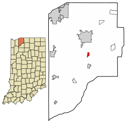
LaPorte County Indiana Incorporated and Unincorporated areas Kingsbury Highlighted 1839816.svg
Location of Kingsbury in LaPorte County, Indiana.
Coordinates: 41°31′49″N86°41′50″W / 41.53028°N 86.69722°W / 41.53028; -86.69722
Country United States
State Indiana
County LaPorte
Township Washington
Area
[1]
  Total0.59 sq mi (1.53 km2)
  Land0.59 sq mi (1.53 km2)
  Water0.00 sq mi (0.00 km2)
Elevation
[2]
751 ft (229 m)
Population
 (2020)
  Total190
  Density320.40/sq mi (123.80/km2)
Time zone UTC-6 (CST)
  Summer (DST) UTC-5 (CDT)
ZIP code
46345
Area code 219
FIPS code 18-39816 [3]
GNIS feature ID2397018 [2]

Kingsbury is a town in Washington Township, LaPorte County, Indiana, just northwest of the intersection of U.S. Route 35 and U.S. Route 6. The town was founded in 1835 [4] and incorporated on March 3, 1941. During 1940 - 1941, the Kingsbury Ordnance Plant (KOP) was built for use during World War II. The plant closed after the war but reopened during the Korean War, closing permanently in 1959. The population was 242 at the 2010 census. It is included in the Michigan City, Indiana-La Porte, Indiana Metropolitan Statistical Area. The town has its own fire department, KVFD (Kingsbury Volunteer Fire Department), and a Greek revival style First Baptist church built in 1851 with its own graveyard and Winchell Cemetery.

Contents

South Main Street, in Kingsbury, Indiana Kingsbury, Indiana S Main St.jpg
South Main Street, in Kingsbury, Indiana

Geography

According to the 2010 census, Kingsbury has a total area of 0.57 square miles (1.48 km2), all land. [5]

Demographics

Historical population
CensusPop.Note
1880 154
1950 281
1960 2810.0%
1970 31411.7%
1980 3294.8%
1990 258−21.6%
2000 229−11.2%
2010 2425.7%
2020 190−21.5%
U.S. Decennial Census [6]

2000 census

As of the census [3] of 2000, there were 229 people, 90 households, and 68 families living in the town. The population density was 391.8 inhabitants per square mile (151.3/km2). There were 94 housing units at an average density of 160.8 per square mile (62.1/km2). The racial makeup of the town was 99.56% White and 0.44% Native American.

There were 90 households, out of which 25.6% had children under the age of 18 living with them, 62.2% were married couples living together, 10.0% had a female householder with no husband present, and 24.4% were non-families. 16.7% of all households were made up of individuals, and 6.7% had someone living alone who was 65 years of age or older. The average household size was 2.54 and the average family size was 2.81.

In the town, the population was spread out, with 22.7% under the age of 18, 10.0% from 18 to 24, 29.3% from 25 to 44, 23.1% from 45 to 64, and 14.8% who were 65 years of age or older. The median age was 38 years. For every 100 females, there were 81.7 males. For every 100 females age 18 and over, there were 84.4 males.

The median income for a household in the town was $50,000, and the median income for a family was $53,438. Males had a median income of $40,417 versus $22,500 for females. The per capita income for the town was $18,096. About 4.6% of families and 9.7% of the population were below the poverty line, including 10.9% of those under the age of eighteen and none of those 65 or over.

2010 census

As of the census [7] of 2010, there were 242 people, 91 households, and 69 families living in the town. The population density was 424.6 inhabitants per square mile (163.9/km2). There were 96 housing units at an average density of 168.4 per square mile (65.0/km2). The racial makeup of the town was 97.1% White, 0.4% African American, 0.4% Native American, and 2.1% from other races. Hispanic or Latino of any race were 5.4% of the population.

There were 91 households, of which 35.2% had children under the age of 18 living with them, 63.7% were married couples living together, 6.6% had a female householder with no husband present, 5.5% had a male householder with no wife present, and 24.2% were non-families. 19.8% of all households were made up of individuals, and 13.2% had someone living alone who was 65 years of age or older. The average household size was 2.66 and the average family size was 3.06.

The median age in the town was 39.8 years. 25.2% of residents were under the age of 18; 6.6% were between the ages of 18 and 24; 29.4% were from 25 to 44; 22.7% were from 45 to 64; and 16.1% were 65 years of age or older. The gender makeup of the town was 49.6% male and 50.4% female.

Related Research Articles

<span class="mw-page-title-main">Milltown, Indiana</span> Town in Indiana, United States

Milltown is a town in Whiskey Run Township in Crawford County, Indiana and in Blue River and Spencer townships in Harrison County. The population was 818 at the time of the 2010 census.

<span class="mw-page-title-main">St. Leon, Indiana</span> Town in Indiana, United States

St. Leon or Saint Leon is a town in Kelso Township, Dearborn County, Indiana, United States. The population was 678 at the 2010 census.

<span class="mw-page-title-main">West Harrison, Indiana</span> Town in Indiana, United States

West Harrison is a town in Harrison Township, Dearborn County, Indiana, United States. The population was 289 at the 2010 census.

<span class="mw-page-title-main">Ashley, Indiana</span> Town in Indiana, United States

Ashley is a town in Indiana located on the border of Smithfield Township, DeKalb County and Steuben Township, Steuben County. The population was 983 at the 2010 census.

<span class="mw-page-title-main">Glenwood, Indiana</span> Town in Indiana, United States

Glenwood is a town in Union Township, Rush County and in Orange and Fairview townships, Fayette County in the U.S. state of Indiana. The population was 250 at the 2010 census.

<span class="mw-page-title-main">McCordsville, Indiana</span> Town in Indiana, United States

McCordsville is a town in Vernon Township, Hancock County, Indiana, United States. The town is a fast-growing suburb of Indianapolis with an estimated population of 8,592 in 2020.

<span class="mw-page-title-main">Medora, Indiana</span> Town in Indiana, United States

Medora is a town in Carr Township, Jackson County, Indiana, United States. The population was 693 at the 2010 census.

<span class="mw-page-title-main">Kingsford Heights, Indiana</span> Town in Indiana, United States

Kingsford Heights is a town in Union Township, LaPorte County, Indiana, United States. The population was 1,335 at the 2020 census. It is included in the Michigan City, Indiana-La Porte, Indiana Metropolitan Statistical Area. Also known as "Victory City," the town was built by the United States government for workers that worked in the Kingsbury Ordnance Plant, an ammunitions plant that served the US during World War II and later the Korean War.

<span class="mw-page-title-main">La Crosse, Indiana</span> Town in Indiana, United States

La Crosse is a town in LaPorte County, Indiana, United States. The population was 551 at the 2010 census. It is included in the Michigan City, Indiana-La Porte, Indiana Metropolitan Statistical Area.

<span class="mw-page-title-main">Michiana Shores, Indiana</span> Town in Indiana, United States

Michiana Shores is a town in Springfield and Michigan townships, LaPorte County, Indiana, United States. The population was 313 at the 2010 census. It is included in the Michigan City, Indiana-La Porte, Indiana Metropolitan Statistical Area. Michiana Shores is located in northwesternmost Springfield Township, and is the township's sole incorporated community.

<span class="mw-page-title-main">Pottawattamie Park, Indiana</span> Town in Indiana, United States

Pottawattamie Park is a town in Michigan Township, LaPorte County, Indiana, United States. The population was 235 at the 2010 census. It is included in the Michigan City, Indiana-La Porte, Indiana Metropolitan Statistical Area.

<span class="mw-page-title-main">Trail Creek, Indiana</span> Town in Indiana, United States

Trail Creek is a town in Coolspring and Michigan townships, LaPorte County, Indiana, United States. The population was 2,052 at the 2010 census. It is included in the Michigan City, Indiana-La Porte, Indiana Metropolitan Statistical Area.

<span class="mw-page-title-main">Wanatah, Indiana</span> Town in Indiana, United States

Wanatah is a town in LaPorte County, Indiana, United States. The population was 1,048 at the 2010 census.

<span class="mw-page-title-main">Westville, Indiana</span> Town in Indiana, United States

Westville is a town in New Durham Township, LaPorte County, Indiana, United States. The population, as of the 2020 census is 5257. It is included in the Michigan City, Indiana-La Porte, Indiana Metropolitan Statistical Area. Westville is located in Northwest Indiana, also known as The Region.

<span class="mw-page-title-main">Paragon, Indiana</span> Town in Indiana, United States

Paragon is a town in Ray Township, Morgan County, in the U.S. state of Indiana. The population was 556 at the 2020 census, down from 659 in 2010.

<span class="mw-page-title-main">Fillmore, Indiana</span> Town in Indiana, United States

Fillmore is a town in Marion Township, Putnam County, in the U.S. state of Indiana. The population was 532 at the 2020 census.

<span class="mw-page-title-main">Walkerton, Indiana</span> Town in Indiana, United States

Walkerton is a town in Lincoln Township, St. Joseph County, in the U.S. state of Indiana. The population was 2,144 at the 2010 Census. It is part of the South Bend–Mishawaka, IN-MI, Metropolitan Statistical Area.

<span class="mw-page-title-main">Hardinsburg, Indiana</span> Census-designated place in Indiana, United States

Hardinsburg is a census-designated place in Posey Township, Washington County, in the U.S. state of Indiana. The population was 222 at the 2020 census.

<span class="mw-page-title-main">La Porte City, Iowa</span> City in Iowa, United States

La Porte City is a city in Black Hawk County, Iowa, United States. The population was 2,284 at the 2020 census. It is part of the Waterloo–Cedar Falls Metropolitan Statistical Area.

<span class="mw-page-title-main">Erwin, South Dakota</span> Town in South Dakota, United States

Erwin is a town in Kingsbury County, South Dakota, United States. The population was 45 at the 2010 census.

References

  1. "2020 U.S. Gazetteer Files". United States Census Bureau. Retrieved March 16, 2022.
  2. 1 2 U.S. Geological Survey Geographic Names Information System: Kingsbury, Indiana
  3. 1 2 "U.S. Census website". United States Census Bureau . Retrieved January 31, 2008.
  4. History of La Porte County, Indiana: Together with Sketches of Its Cities, Villages, and Townships. C. C. Chapman & Co. 1880. pp.  865.
  5. "G001 - Geographic Identifiers - 2010 Census Summary File 1". United States Census Bureau. Archived from the original on February 13, 2020. Retrieved July 17, 2015.
  6. "Census of Population and Housing". Census.gov. Retrieved June 4, 2015.
  7. "U.S. Census website". United States Census Bureau . Retrieved December 11, 2012.