
East Lothian is one of the 32 council areas of Scotland, as well as a historic county, registration county and lieutenancy area. The county was called Haddingtonshire until 1921.

The Firth of Forth is the estuary, or firth, of several Scottish rivers including the River Forth. It meets the North Sea with Fife on the north coast and Lothian on the south.
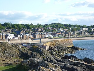
North Berwick is a seaside town and former royal burgh in East Lothian, Scotland. It is situated on the south shore of the Firth of Forth, approximately 20 miles (32 km) east-northeast of Edinburgh. North Berwick became a fashionable holiday resort in the nineteenth century because of its two sandy bays, the East Bay and the West Bay, and continues to attract holidaymakers. Golf courses at the ends of each bay are open to visitors.

Fidra is a currently uninhabited island in the Firth of Forth, 4 kilometres northwest of North Berwick, on the east coast of Scotland. The island is an RSPB Scotland nature reserve.
Drem is a small village in East Lothian, Scotland.

Gullane is a town on the southern shore of the Firth of Forth in East Lothian on the east coast of Scotland. There has been a church in the village since the ninth century. The ruins of the Old Church of St. Andrew built in the twelfth century can still be seen at the western entrance to the village; the church was abandoned after a series of sandstorms made it unusable, and Dirleton Parish Church took its place.

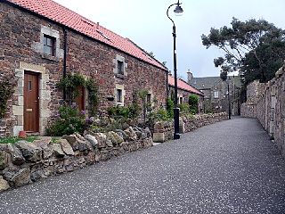
Dirleton is a village and civil parish in East Lothian, Scotland approximately 20 miles (32 km) east of Edinburgh on the A198. It contains 7,500 acres (30 km2). Dirleton lies between North Berwick (east), Gullane (west), Fenton Barns (south) and the Yellowcraigs nature reserve, Archerfield Estate and the Firth of Forth (north). Gullane parish was joined to Dirleton parish in 1612 by an Act of Parliament because "Golyn is ane decaying toun, and Dirleton is ane thriven place."

Crawford Castle, substantially in ruins, is located on the north bank of the River Clyde, around 1⁄2 mile north of Crawford, South Lanarkshire, Scotland. The ruins stand on an earlier motte and bailey earthwork. The castle is also known as Lindsay Tower, after its former owners, the Lindsay family. The strategic location of the castle, at NS954213, guards the strategically important Mennock Pass from England into the upper Clyde Valley.

Dirleton Castle is a medieval fortress in the village of Dirleton, East Lothian, Scotland. It lies around 2 miles (3.2 km) west of North Berwick, and around 19 miles (31 km) east of Edinburgh. The oldest parts of the castle date to the 13th century, and it was abandoned by the end of the 17th century.

The hamlets of Fenton Barns, East Fenton and West Fenton make up a rural community in East Lothian, Scotland, approximately 20 miles (32 km) east of Edinburgh and close to the settlements of North Berwick, Drem, Dirleton and Gullane.

Auldhame and Scoughall are hamlets in East Lothian, Scotland. They are close to the town of North Berwick and the village of Whitekirk, and are approximately 25 miles (40 km) east of Edinburgh.
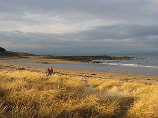
Yellowcraig, also known as Broad Sands Beach, is a coastal area of forest, beach and grassland in East Lothian, south-east Scotland. Yellowcraig is partly within the Firth of Forth Site of Special Scientific Interest (SSSI). It is bordered to the north by the Firth of Forth, to the south by the village of Dirleton and Dirleton Castle, to the east by the North Berwick West Links golf course, and to the west by the Archerfield Estate and Links golf courses.
Archerfield and Archerfield Links are a country house and pair of golf courses in the parish of Dirleton, East Lothian, Scotland. An older golf course, also called Archerfield Links, occupied the area before falling into disuse after World War II.

The Islands of the Forth are a group of small islands located in the Firth of Forth and in the estuary of the River Forth on the east coast of Scotland. Most of the group lie in the open waters of the firth, between the Lothians and Fife, with the majority to the east of the city of Edinburgh. Two islands lie further west in the river estuary.
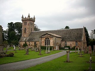
Dirleton Kirk is a church in the village of Dirleton, in East Lothian, Scotland.
The feudal barony of Dirleton was a feudal barony with its caput baroniae originally at Castle Tarbet, Elbottle Castle and later at Dirleton Castle in East Lothian, Scotland. The Lordship & Barony of Dirleton lay in East Lothian a few miles west of North Berwick, the land comprising the Caput of the Barony is today only a little over 40 acres, including the Island of Lamb, North and South Dogs in the east coast of Scotland. Its ruined castle, two triangular greens and the buildings are grouped in the traditional style of a medieval township. Dirleton Castle was built in the middle of the twelfth century by a branch of the Anglo-Norman family of De Vaux, a family with its origins in Rouen, Normandy, which had settled in Dirleton during the reign of King Malcolm IV (1153‒1165). The original castle was modelled on contemporary French castles, in particular Coucy la Chateaux north of Paris. Dirleton Castle was defended against the invading army of Edward I of England in June 1298, but eventually fell to Anthony Beck, the fighting Bishop of Durham. In 1311 the castle was recaptured by the Scots and Robert the Bruce ordered that it be reduced (ruined) to eliminate the possibility of it being occupied by the English in the future. Dirleton was in the hands of the De Vaux family for about two centuries.
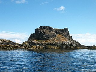
Castle Tarbet is located on the island of Fidra, East Lothian, within the Firth of Forth, Scotland.
John I de Vaux, also known as Johannem de Vaus, Baron of Dirleton, was a prominent 12th-century Scottish noble.

James Smith Richardson (1883–1970) was a Scottish architect, antiquarian and archaeologist. He was the first Inspector of Ancient Monuments for Scotland, and was responsible for a series of popular guidebooks to monuments in public care.


