
Corfe Castle is a village and civil parish in the English county of Dorset. It is the site of a ruined castle of the same name. The village and castle stand over a gap in the Purbeck Hills on the route between Wareham and Swanage. The village lies in the gap below the castle and is around four miles (6.4 km) south-east of Wareham, and four miles (6.4 km) north-northwest of Swanage. Both the main A351 road from Lytchett Minster to Swanage and the Swanage Railway thread their way through the gap and the village.

The Isle of Purbeck is a peninsula in Dorset, England. It is bordered by water on three sides: the English Channel to the south and east, where steep cliffs fall to the sea; and by the marshy lands of the River Frome and Poole Harbour to the north. Its western boundary is less well defined, with some medieval sources placing it at Flower's Barrow above Worbarrow Bay. According to writer and broadcaster Ralph Wightman, Purbeck "is only an island if you accept the barren heaths between Arish Mell and Wareham as cutting off this corner of Dorset as effectively as the sea." The most southerly point is St Alban's Head.
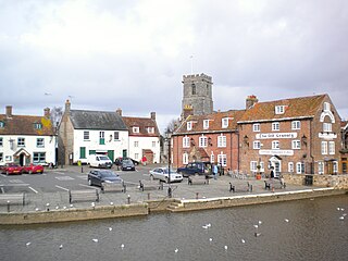
Wareham is a historic market town and, under the name Wareham Town, a civil parish, in the English county of Dorset. The town is situated on the River Frome eight miles (13 km) southwest of Poole.

Portesham, sometimes also spelled Portisham, is a village and civil parish in the county of Dorset in southwest England, situated in the Dorset Council administrative area approximately 6 miles (10 km) northwest of Weymouth, 6 miles (10 km) southwest of the county town Dorchester, and 2 miles (3 km) northeast of the Jurassic Coast World Heritage Site at Chesil Beach. The parish is quite large, covering several outlying hamlets and what were once their manors. In the 2011 census it had a population of 685 in 316 households and 342 dwellings.

Purbeck was a local government district in Dorset, England. The district was named after the Isle of Purbeck, a peninsula that forms a large proportion of the district's area. However, it extended significantly further north and west than the traditional boundary of the Isle of Purbeck which is the River Frome. The district council was based in the town of Wareham, which is itself north of the Frome.

Corfe Mullen is a village in Dorset, England, on the north-western urban fringe of the South East Dorset conurbation. The village had a population of 10,133 at the 2011 Census. It is served by six churches, four pubs, five schools, a library, various shops and local businesses, a village hall, and many community and sports organisations. On 10 December 2019 The Corfe Mullen Parish Council resolved to adopt Town Council status, citing potential financial benefits. In all other aspects Corfe Mullen is still very much a village, albeit a large one.

Worth Matravers is a village and civil parish in the English county of Dorset. The village is situated on the cliffs west of Swanage. It comprises limestone cottages and farm houses and is built around a pond, which is a regular feature on postcards of the Isle of Purbeck.

Church Knowle is a village and civil parish on the Isle of Purbeck in the county of Dorset in the south of England.

Swyre Head is the highest point of the Isle of Purbeck in Dorset, on the south coast of England. The hill Swyre Head lies about 2 kilometres (1 mi) southwest of the village Kingston, about 5 kilometres (3 mi) south of Corfe Castle and 8 kilometres (5 mi) west of Swanage.
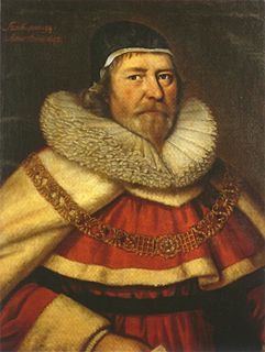
The Bankes family were prominent landed gentry in Dorset, England, for over 400 years. They owned large portions of land throughout Dorset and made significant contributions to the political history and development of the country.

Creech Grange is an elegant country house in Steeple, south of Wareham in Dorset at the foot of the Purbeck Hills. Historic England designate it as a Grade I listed building. The park and gardens are Grade II* listed in the National Register of Historic Parks and Gardens.
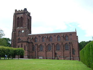
St Mary's Church is in the village of Eccleston, Cheshire, England, on the estate of the Duke of Westminster south of Chester. The church is recorded in the National Heritage List for England as a designated Grade I listed building. It is an active Anglican parish church in the diocese of Chester, the archdeaconry of Chester and the deanery of Chester. Its benefice is combined with that of St Mary, Pulford. The Dukes of Westminster are buried in the adjacent Old Churchyard.

St Aldhelm's Chapel is a Norman chapel on St Aldhelm's Head in the parish of Worth Matravers, Swanage, Dorset. It stands close to the cliffs, 108 metres (354 ft) above sea level. It is a Grade I listed building.

Corfe Castle is a fortification standing above the village of the same name on the Isle of Purbeck peninsula in the English county of Dorset. Built by William the Conqueror, the castle dates to the 11th century and commands a gap in the Purbeck Hills on the route between Wareham and Swanage. The first phase was one of the earliest castles in England to be built at least partly using stone when the majority were built with earth and timber. Corfe Castle underwent major structural changes in the 12th and 13th centuries.
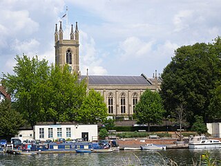
St Mary's Parish Church, Hampton, is an Anglican church in Hampton in the London Borough of Richmond upon Thames.
George Bankes (1788–1856) was the last of the Cursitor Barons of the Exchequer, the office being abolished by Conservative ministry of the Earl of Derby in 1852. Without any legal experience at the bar, he was the last barrister to be appointed to the post considered to be a medieval anachronism.

St Mary's Church is in the village of Acton Burnell, Shropshire, England, and stands near the ruins of Acton Burnell Castle. It is an active Anglican parish church in the deanery of Condover, the archdeaconry of Ludlow, and the diocese of Hereford. Its benefice is united with those of St Andrew and St Mary, Condover, St Mark, Frodesley, and St Michael and All Angels, Pitchford. The church is recorded in the National Heritage List for England as a designated Grade I listed building.
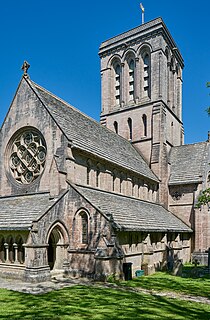
The Church of St James is the parish church for the village of Kingston, located on the Isle of Purbeck in Dorset. The church is a notable example of the Gothic Revival style and is a Grade I listed building.

St Aldhelm's Church is a private church in Lytchett Heath, Dorset, England. It was designed by George Crickmay for Lord Eustace Cecil and built in 1898. It has been a Grade II* listed building since 1984. The lychgate of the churchyard is also Grade II listed.

St Hubert's Church is a 13th-century Church of England parish church in Corfe Mullen, a district of Wimborne, in the ceremonial county of Dorset, on the south coast of England. It is a Grade II* listed building and one of two churches in the Anglican parish of Corfe Mullen that form "one church family" offering a mix of "traditional and contemporary worship". The church is a popular venue for weddings.


