Kinzie Street railroad bridge

Last updated

Kinzie Street railroad bridge
KinzieStRRBrdg08.jpg
Kinzie Street railroad bridge permanently locked in the raised position
Coordinates 41°53′18.7″N87°38′21″W / 41.888528°N 87.63917°W / 41.888528; -87.63917
Crosses Chicago River
Locale Chicago
Official nameChicago and North Western Railway, Kinzie Street Bridge
Other name(s)Carroll Avenue bridge
Owner Union Pacific Railroad
Heritage status Chicago Landmark
Characteristics
Design bascule bridge
Total length195.83 feet (59.69 m) [1]
Width41.7 feet (12.7 m) [1]
Longest span170 feet (52 m) [1]
History
Construction startDecember 1907
OpenedSeptember 19, 1908 [1]
Location
Kinzie Street railroad bridge

The Chicago and North Western Railway's Kinzie Street railroad bridge (also known as the Carroll Avenue bridge or the Chicago and North Western Railroad Bridge) is a single leaf bascule bridge across the north branch of the Chicago River in downtown Chicago, Illinois. At the time of its opening in 1908 it was the world's longest and heaviest bascule bridge. The previous bridges on the same site included a pedestrian span that was the first bridge across the Chicago River; a second bridge that served as Chicago's first railroad bridge; and a third bridge that was one of the first all-steel spans in the United States.

Contents

The Chicago Sun-Times , the last railroad customer to the east of the bridge, moved their printing plant out of downtown Chicago in 2000, and the bridge has been unused since. It was designated a Chicago Landmark in 2007. The bridge is lowered once a year and inspected by crew driving a Hi-Rail truck, and is still in "active" status. [2] [3]

Location

Night view looking north from Lake Street bridge showing Wolf Point and Kinzie Street railroad bridge. Among the buildings and structures shown are (left to right) Left Bank at K Station (300 North Canal), 333 North Canal, Kinzie Street railroad bridge, 350 North Orleans, Merchandise Mart, 300 North LaSalle, Franklin Street Bridge and part of 333 Wacker Drive. Chicago River from Lake Street bridge.jpg
Night view looking north from Lake Street bridge showing Wolf Point and Kinzie Street railroad bridge. Among the buildings and structures shown are (left to right) Left Bank at K Station (300 North Canal), 333 North Canal, Kinzie Street railroad bridge, 350 North Orleans, Merchandise Mart, 300 North LaSalle, Franklin Street Bridge and part of 333 Wacker Drive.

The Kinzie Street railroad bridge runs in an east-west orientation, spanning the north branch Chicago River between the Near North Side and Near West Side community areas of Chicago. To the south is the historic area of Wolf Point at the confluence of the main stem of the Chicago River with the north and south branches, and to the east is 350 West Mart Center and Merchandise Mart. The railroad track across the bridge is a spur line of the Union Pacific Railroad, [1] that branches off from the route of the Union Pacific/North Line about 1 mile (1.6 km) northwest of the bridge. [4] The railroad to the east of the bridge has no customers since 2000. [5]

Previous bridges

Railroad bridge in 1865. Out from the Darkness- An Autobiography Unfolding the Life Story and Singular Vicissitudes of a Scandinavian Bartimaeus (1890) (14765983255).jpg
Railroad bridge in 1865.

Through the 1820s a small settlement grew around Wolf Point, at the forks of the Chicago River. In June 1829, Samuel Miller—who owned a tavern on the north shore of the river beside the forks—and Archibald Clybourne were authorized to run a ferry across the mouth of the north branch of the river, just south of the present Kinzie Street. [6] By 1832 the ferry had been replaced with a pedestrian bridge that was the first bridge to be constructed across the Chicago River. [7]

Bird's-eye view of Wolf Point viewed from the east as it appeared in 1893. The 1879-1898 swing bridge is visible in the top right of the drawing. Wolf Point 1893.jpg
Bird's-eye view of Wolf Point viewed from the east as it appeared in 1893. The 1879–1898 swing bridge is visible in the top right of the drawing.

On October 10, 1848 the Galena and Chicago Union Railroad—Chicago's first railroad—began operating out of a depot on the west side of the Chicago River, near the corner of Canal and Kinzie Streets. Though the City of Chicago had authorized the railroad to construct a bridge across the north branch of the river as early as July 17, 1848, [8] it was not until 1851 that the railroad began to purchase the land needed to build the Wells Street Station to the east of the river. [9] In order to access the new station a floating pontoon bridge designed by Jenks D. Perkins was built across the north branch at roughly the same location as the earlier pedestrian bridge. This bridge—the first railroad bridge in Chicago—was completed in 1852, [1] [10] allowing trains to access the railroad's new Wells Street Station and subsequently industry on the north bank of the Chicago River as far as the Ogden Slip and Navy Pier. [4] [11]

The original railroad bridge was replaced by a swing bridge in 1879 that, along with the Glasgow Railroad Bridge across the Missouri River, was one of the United States' first all-steel railroad bridges. [12] This bridge was constructed from Bessemer steel, which proved too brittle and so the bridge was replaced again in 1898. [1] The replacement bridge was constructed on land and floated into position, allowing the old structure to be removed and the new one put in place in 27½ hours on March 13 and March 14, 1898. [13] [14]

Bascule bridge

1897 plan of the North Branch of the Chicago River showing the close proximity of the three bridges at Kinzie Street, and the obstruction that they created in the river Chicago River bridges at Kinzie St 1897.jpg
1897 plan of the North Branch of the Chicago River showing the close proximity of the three bridges at Kinzie Street, and the obstruction that they created in the river

River traffic and railroad traffic were increasingly in competition with each other. In October 1879 a disaster was narrowly avoided when a seven-coach passenger train with 800 people on board approached the open swing bridge too fast and was barely able to stop in time, ending up with its front wheels hanging off the approach road over the river. [15] Meanwhile, boats on the river were getting larger and finding it increasingly difficult to navigate the bridges at the mouth of the north branch, so the Army Corps of Engineers ordered the clearing of three swing bridges near Kinzie Street that were obstructing river traffic. [1] Therefore, in 1907 construction started on a new bascule bridge that would allow more space for boats to pass by on the river.

Design and construction

Schematic of Kinzie Street railroad bridge Kinzie Street railroad bridge schematic.png
Schematic of Kinzie Street railroad bridge

The bridge is designed to carry two railroad tracks across the river. Its superstructure consists of two spans constructed by the Strauss Bascule & Concrete Bridge Company: a 26-foot (7.9 m) plate-girder span on the west bank of the river and the 170-foot (52 m) movable main span that rests on the east trunnion pier. [1] The size and weight of the main span, which, when completed would be world's longest and heaviest bascule span, [1] required the trunnion pier to be constructed on foundations that extend to the bedrock 94 feet (29 m) below the river bed. To achieve this caissons were sunk to a depth of 29 feet (8.8 m) below the river bed and then 10-foot (3.0 m) diameter wells were sunk the remaining 65 feet (20 m). [16] The substructure of the bridge was constructed by the Great Lakes Dredge and Dock Company.

Usage

The Chicago and North Western Railway originally planned for two bridges side-by-side that could carry four railroad tracks into the Wells Street Station. [9] However, by the time that the first bridge opened on September 19, 1908 an alternative scheme was already underway that led to the closure of Wells Street Station and its replacement with a new terminal on the west bank of the river. When the new Chicago and Northwestern terminal at 500 Madison Street (now the Ogilvie Transportation Center) opened in 1911, Kinzie Street railroad bridge was left to handle freight traffic only. In 1930 the Merchandise Mart was opened on the site of the old Wells Street Station. Merchandise Mart was built on air rights of the Chicago and North Western, and in the spring of 1932 the railroad opened a new freight house underneath the building that was designed to handle 1,000 short tons (910,000 kg) of outbound and 600 short tons (540,000 kg) of inbound freight per day. [17] [18]

Abandonment

During the second half of the 20th century the number of companies using the railroad for shipping on Chicago's near north side declined severely. [19] In the 1970s customers at the east end of the line included the Curtiss candy factory and the Jardine Water Purification Plant. [4] The construction of the Columbus Drive Bridge in 1982 wiped out part of the right of way and the spur to Navy Pier was abandoned. [4] Service to the Tribune Tower also ended in the 1980s, [4] and by the 1990s traffic along the remaining section of the spur served only one customer, the Chicago Sun-Times, with only one train per day. [20] The newspaper moved their printing plant out of downtown Chicago in early 2001 leaving no traffic across the bridge and it has since been permanently raised in the open position. [4] [21] On December 12, 2007 the bridge was one of 12 historic Chicago railroad bridges to be designated as Chicago Landmarks. [22]

Proposals for reuse

Tests were conducted in 1953 to see if the spur could be used as a part of a commuter line with stops at Merchandise Mart, State Street, and Michigan Avenue, but the plan was dropped in 1954 for financial reasons. [4] In the 1970s architect Harry Weese suggested a light rail line along the spur to connect Chicago's downtown stations with the River North neighborhoods. [4] In 2008 the City of Chicago Department of Transportation commissioned an alternatives analysis to look at a proposal to create a transit link from Union Station and the Ogilvie Transportation Center to Michigan Avenue using the Union Pacific train tunnel running under the Apparel Center, the Merchandise Mart and other buildings east toward North Michigan Avenue. The proposed Carroll Avenue Transitway would include the retrofitting of Kinzie Street railroad bridge to carry buses or trams. [23]

See also

Related Research Articles

<span class="mw-page-title-main">Chicago River</span> System of rivers and canals running through the city of Chicago

<span class="mw-page-title-main">Merchandise Mart</span> Commercial building in Chicago, Illinois, USA

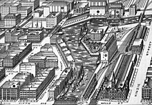
The Merchandise Mart is a commercial building located in downtown Chicago, Illinois. When it was opened in 1930, it was the largest building in the world, with 4 million square feet (372,000 m2) of floor space. The Art Deco structure is located at the junction of the Chicago River's branches. The building is a leading retailing and wholesale location, hosting 20,000 visitors and tenants per day in the late 2000s.

<span class="mw-page-title-main">Galena and Chicago Union Railroad</span>

The Galena and Chicago Union Railroad (G&CU) was a railroad running west from Chicago to Freeport, Illinois, never reaching Galena, Illinois. A later route went to Clinton, Iowa. Incorporated in 1836, the G&CU became the first railroad built out from Chicago.

<span class="mw-page-title-main">Burlington Northern Railroad Bridge 5.1</span> Railroad bridge in Portland, Oregon

The Burlington Northern Railroad Bridge 5.1 or BNSF Railway Bridge 5.1, also known as the St. Johns Railroad Bridge or the Willamette River Railroad Bridge, is a through truss railway bridge with a vertical lift that spans the Willamette River in Portland, Oregon, United States. Built by the Spokane, Portland and Seattle Railway (SP&S) and completed in 1908, it was originally a swing-span bridge, and its swing-span section was the longest in the world at the time. However, 81 years later the main span was converted from a swing-type to a vertical-lift type, in order to widen the navigation channel. The lift span is one of the highest and longest in the world. The bridge consists of five sections, with the two sections closest to the bank on each side fixed.

<span class="mw-page-title-main">Goose Island (Chicago)</span> Artificial island in Chicago, Illinois, US

Goose Island is a 160-acre (65-hectare) artificial island in Chicago, Illinois, formed by the North Branch of the Chicago River on the west and the North Branch Canal on the east. It is about 1+12 miles long and 12 mile across at its widest point.

<span class="mw-page-title-main">Grand Central Station (Chicago)</span> Train station in Chicago, Illinois, US

Grand Central Station was a passenger railroad terminal in downtown Chicago, Illinois, from 1890 to 1969. It was located at 201 West Harrison Street on a block bounded by Harrison, Wells and Polk Streets and the Chicago River in the southwestern portion of the Chicago Loop. Grand Central Station was designed by architect Solon Spencer Beman for the Wisconsin Central Railroad (WC), and was completed by the Chicago and Northern Pacific Railroad.

<span class="mw-page-title-main">St. Charles Air Line</span> Rail corridor in Chicago

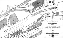
The St. Charles Air Line is a rail line in Chicago, Illinois, partially owned by the BNSF Railway, Union Pacific Railroad, and Canadian National Railway.

<span class="mw-page-title-main">Wells Street Station</span>

Wells Street Station was a passenger terminal of the Chicago and North Western Railway, located at the southwest corner of Wells Street and Kinzie Street in Chicago, Illinois. It was replaced in 1911 by the Chicago and North Western Terminal on the other (west) side of the North Branch of the Chicago River, removing passenger trains from the Kinzie Street railroad bridge over the river. The Merchandise Mart opened in 1930 on the land formerly occupied by the station.

<span class="mw-page-title-main">Merchandise Mart station</span> Chicago "L" station

Merchandise Mart is a station on the Chicago Transit Authority's 'L' system, located in the Near North Side neighborhood at 350 North Wells Street in Chicago, Illinois. The station is elevated above street level, on a steel structure. The turnstiles and customer assistant booth of the station are located on the second level of the Merchandise Mart itself. This is the main entrance to the station.

<span class="mw-page-title-main">DuSable Bridge</span> Bridge in Chicago, Illinois

The DuSable Bridge is a bascule bridge that carries Michigan Avenue across the main stem of the Chicago River in downtown Chicago, Illinois, United States. The bridge was proposed in the early 20th century as part of a plan to link Grant Park (downtown) and Lincoln Park (uptown) with a grand boulevard. Construction of the bridge started in 1918, it opened to traffic in 1920, and decorative work was completed in 1928. The bridge provides passage for vehicles and pedestrians on two levels. An example of a fixed trunnion bascule bridge, it may be raised to allow tall ships and boats to pass underneath. The bridge is included in the Michigan–Wacker Historic District and has been designated as a Chicago Landmark.

<span class="mw-page-title-main">North Avenue Bridge</span> Bridge in Chicago, Illinois

The North Avenue Bridge can refer to one of three bridges that has carried North Avenue over the North Branch of the Chicago River on the north side of Chicago, Illinois. A center-pier swing bridge built in 1877 was replaced in 1907 by a bascule bridge, allowing river traffic more room for maneuvering in and out of the North Canal, just north of Goose Island.

<span class="mw-page-title-main">Franklin Street Bridge</span> Bridge in Chicago, Illinois, U.S.

The Franklin–Orleans Street Bridge, commonly known as the Franklin Street Bridge, is a bascule bridge over the Chicago River, in Chicago, Illinois, United States. It was built in October 1920, and is located directly southwest of the Merchandise Mart. Connecting the Near North Side with "The Loop," is at the junction of the branches of the river, lying directly west of the Wells Street Bridge. It carries four lanes of traffic in the northbound direction, and sidewalks are available on both sides of the bridge.

<span class="mw-page-title-main">Wells Street Bridge (Chicago)</span> Bridge in Chicago, Illinois, U.S.

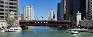
The Wells Street Bridge is a bascule bridge over the Chicago River, in downtown Chicago, Illinois, United States, which was built in 1922. Standing east of the Franklin Street Bridge and southeast of the Merchandise Mart, the bridge connects the Near North Side with "The Loop". The bridge is double-decked, the lower deck carrying three lanes of traffic south over the river with sidewalks on both sides of the street. The upper deck serves as a bridge for the Chicago Transit Authority's Brown and Purple lines. Bridge tenders' houses for controlling the bridge are on the northwest and southeast corners of the bridge.

<span class="mw-page-title-main">Cortland Street Drawbridge</span> American bridge

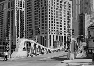
The Cortland Street Drawbridge over the Chicago River is the original Chicago-style fixed-trunnion bascule bridge, designed by John Ericson and Edward Wilmann. When it opened in 1902, on Chicago's north side, it was the first such bridge built in the United States. The bridge was a major advance in American movable bridge engineering, and was the prototype for over 50 additional bridges in Chicago alone. The bridge was designated as an ASCE Civil Engineering Landmark in 1981, and a Chicago Landmark in 1991.

<span class="mw-page-title-main">Minneapolis Great Northern Depot</span> Demolished train station in Minnesota

The Minneapolis Great Northern Depot, also known as Great Northern Station, was a passenger railroad station which served Minneapolis, Minnesota, USA. It was built in 1913 and demolished in 1978. It was located on Hennepin Avenue next to the Hennepin Avenue Bridge and across the street from the main Minneapolis Post Office.

<span class="mw-page-title-main">Canal Street railroad bridge</span> Bridge in Chicago

The Canal Street railroad bridge is a vertical-lift bridge across the south branch of the Chicago River in Chicago, Illinois. It was designated a Chicago Landmark on December 12, 2007.

<span class="mw-page-title-main">Cherry Avenue Bridge</span> Bridge in Chicago, Illinois, U.S.

The Cherry Avenue Bridge is an asymmetric bob-tail swing bridge in Chicago, Illinois that carries the Chicago Terminal Railroad, pedestrians, and cyclists across the North Branch Canal of the Chicago River. It was constructed in 1901–02 by the Chicago, Milwaukee and St. Paul Railway, and it is a rare example of this type of bridge; it was designated a Chicago Landmark on December 12, 2007.

<span class="mw-page-title-main">Newark and New York Railroad</span>

The Newark and New York Railroad was a passenger rail line that ran between Downtown Newark and the Communipaw Terminal at the mouth of the North River in Jersey City, bridging the Hackensack River and Passaic River just north of their mouths at the Newark Bay in northeastern New Jersey. The Central Railroad of New Jersey operated it from its opening in 1869. Though operations ended in 1946; portions remained in use until 1967.

References

  1. 1 2 3 4 5 6 7 8 9 10 Spivey, Justin M. "Chicago & Northwestern Railway, Kinzie Street Bridge" (PDF). Historic American Engineering Record. Library of Congress. Retrieved February 10, 2015.
  2. Chicago River bridge that allows one truck per year lowered Thursday WGN Radio, November 20, 2015, Original source BY DNAINFO.COM
  3. Nitkin, Alex - The Chicago Bridge That's Always Up Finally Goes Down For Just One Truck Archived 2017-08-07 at the Wayback Machine , November 19, 2015, DNAINFO.COM
  4. 1 2 3 4 5 6 7 8 Goldsborough, Bob (June 23, 2002). "A bend in the tracks - Rail spur from Streeterville's industrial past seen as surface, light-rail link in city's future". Chicago Tribune.
  5. Mann, Thomas (2004). "Navy Pier Line Study". Chicago Switching. Archived from the original on July 8, 2011. Retrieved July 19, 2010.
  6. Andreas, Alfred Theodore (1884). History of Chicago. Vol. 1. New York: Arno Press. p. 104. ISBN   0-405-06845-X . Retrieved July 19, 2010.
  7. Chicago, 1835 (Map). Albert F. Scharf. 1908.
  8. Tuley, Murray F. (1873). Laws and Ordinances Governing the City of Chicago. Chicago: Bulletin printing company. pp. 268–269.
  9. 1 2 Yesterday and today: a history of the Chicago and North Western railway system. Chicago and North Western Railway Company. 1910. pp. 34–35. Retrieved July 19, 2010.
  10. Historic American Engineering Record historian Justin M. Spivey notes that the 1852 pontoon bridge may have been short-lived, as a bird's-eye view of Chicago published in 1857 shows what appears to be a swing bridge crossing the river at this location. See: Spivey, Justin M. "Chicago & Northwestern Railway, Kinzie Street Bridge" (PDF). Historic American Engineering Record. Library of Congress. Retrieved February 10, 2015. and Inger, Christian; Palmatary, James T. "Bird's Eye View of Chicago, 1857". The Electronic Encyclopedia of Chicago. Chicago Historical Society. Retrieved July 22, 2010.
  11. "CNW's Navy Pier Line". Chicago Switching. Archived from the original on July 8, 2011. Retrieved October 8, 2010.
  12. Misa, Thomas J. (1995). A Nation of Steel: The Making of Modern America, 1865-1925 . JHU Press. p.  75. ISBN   0-8018-6052-0.
  13. Finley, William H (February 1899). "Rebuilding of the Kinzie Street Drawbridge of the Chicago & Northwestern Ry". Journal of the Western Society of Engineers. 4 (1): 51–72. Retrieved July 21, 2010.
  14. "Change in Railway Bridge; Little Delay to Traffic". Chicago Daily Tribune. August 21, 1907.
  15. "Narrow Escape. A Train Stops on the Brink of the River". Chicago Daily Tribune. October 10, 1879.
  16. Colby, Frank Moore, ed. (1911). New International Yearbook: A Compendium of the World's Progress for the year 1910. New York: Dodd, Mead and Company. p.  263.
  17. "Opens Notable Freight House on Air Rights Property". Railway Age: 471–473. 1935.
  18. Grant, H. Roger (1996). The North Western: A History of the Chicago & North Western Railway System. DeKalb: Northern Illinois University Press. p. 154. ISBN   0-87580-214-1.
  19. Mann, Thomas. "The Decline of Railroad Customers Chart". Chicago Switching. MannResearch. Archived from the original on July 8, 2011. Retrieved July 21, 2010.
  20. Mika, J (1999). "Afternoon Train on Carroll Avenue" . Retrieved July 19, 2010.
  21. Larson, Lisa (November 1, 2001). "Chicago Sun-Times in full production at new $120m plant". Newspapers & Technology. Archived from the original on July 2, 2007. Retrieved February 19, 2008.
  22. "CHICAGO LANDMARKS: Individual Landmarks and Landmark Districts designated as of January 1, 2008" (PDF). Commission on Chicago Landmarks. January 1, 2008. Archived from the original (PDF) on February 27, 2008. Retrieved February 19, 2008.{{cite journal}}: Cite journal requires |journal= (help)
  23. "About that old train bridge... City would use it to link trains with Michigan Ave". Chicago Sun Times. November 3, 2008.