Kirk Ella

Last updated

Kirk Ella
Village and civil parish
Godmans Lane, Kirk Ella - geograph.org.uk - 999873.jpg
Godmans Lane, Kirk Ella
Kirk Ella and West Ella UK parish locator map.svg
East Riding of Yorkshire UK location map.svg
Red pog.svg
Kirk Ella
Location within the East Riding of Yorkshire
Population5,638 (2011 census) [1]
OS grid reference TA018294
  London 155 mi (249 km)  S
Civil parish
  • Kirk Ella
Unitary authority
Ceremonial county
Region
Country England
Sovereign state United Kingdom
Post town HULL
Postcode district HU10
Dialling code 01482
Police Humberside
Fire Humberside
Ambulance Yorkshire
UK Parliament
List of places
UK
England
Yorkshire
53°45′06″N0°27′24″W / 53.751759°N 0.456585°W / 53.751759; -0.456585

Kirk Ella is a village and civil parish on the western outskirts of Kingston upon Hull, approximately five miles (eight kilometres) west of the city centre, situated in the East Riding of Yorkshire, England. The parish includes West Ella.

Contents

Kirk Ella has been a village since at least the 11th century: it remained a relatively unimportant hamlet until the 18th and 19th centuries, when it became a location of choice for merchants of Hull wishing to live outside the city. Several large houses were built during this period, without any substantial increase in village population. After the 1920s, the village grew substantially, with large amounts of high quality housing surrounding the traditional village centre. The village continued to grow during the second half of the 20th century, becoming a large suburb, contiguous with Anlaby and Willerby.

The civil parish is called "Kirk Ella and West Ella". [2]

Geography

Kirk Ella is primarily residential, but has a few shops. Modern Kirk Ella is contiguous with the suburbs of Willerby to the north; and Anlaby to the east; the village of West Ella is to the west, separated by a golf course; to the south is Hessle separated by under one kilometre (58 mile) of fields. [3]

The village skirts the foothills of the Yorkshire Wolds to the west, and rises from around 10 to 40 metres (35–130 ft) above sea level east to west. Housing stock is affluent, much of it detached or semi detached, with large back gardens; street layouts are irregular, curved, with no main roads passing through the village. [3] Much of the housing development is to the south-east of the original village centre, and church. [3] [4] An area of Kirk Ella including the church, Church Lane, and parts of Packman Lane and Godmans Lane has been designated a conservation area (since 1974), mainly due to its interesting and varied housing stock. The large gardens in much of the village contribute to a wide variety of native and non-native trees and bushes, and thriving wildlife. [5]

Kirk Ella lies within the Parliamentary constituency of Haltemprice and Howden. [6]

The farm known as Kirk Ella Grange is to the north-west, far outside the village, halfway between Raywell and West Ella. [3]

The civil parish is located at the north-western edge of the suburbs of Kingston upon Hull, within the East Riding of Yorkshire. The parish is bounded by the former route of the Hull and Barnsley Railway to the north-east, including an embanked section, and part of the route converted to the B1232 road; by the A164 road to the west and north-west; and by the B1231 to the south. [7] [3]

The parish covers an area of 523.715 hectares (1,294+18 acres), [8] and is situated at heights of between 10 and 60 m (35 and 195 ft) above sea level, rising east to west. [3]

Kirk Ella forms much of the eastern part of the parish, and its urban spread is contiguous with Willerby and Anlaby outside the parish to the north-east and east. The western part of the parish includes the small village of West Ella, and undeveloped land, including a golf course, and woods. [3] The civil parishes of Anlaby with Anlaby Common, Swanland, Skidby and Willerby are to the south, west, north-west, and north-east respectively.

According to the 2011 UK census, the parish had a population of 5,638, [1] a decrease on the 2001 UK census figure of 5,661. [9]

History

Early history

Known archaically as Aluengi (Domesday Book), [10] or Kirk-Elveley. [11]

The name "Kirk Ella" is thought to derive from the Old English, and mean "Aelf(a)'s Woodland Clearing with a Church". [12]

Kirk Ella appears in the 11th century Domesday survey as Aluengi (Ella). [10] There is some evidence for human activity in the area as far back as the Bronze Age – bronze axes have been discovered in the area, [13] [14] pottery from the Roman period has also been found, [15] and an Iron Age enclosure visible as cropmarks has been found halfway between the village and Swanland. [16]

After the Norman conquest the village was the property of Ralph de Mortimer, as part of the manor of Ferriby. Ownership passed to the Wake family during the reign of Edward II. Part of the land was given by Thomas Wake (1297–1349) to Haltemprice Priory. [17]

The Wheatsheaf pub with St Andrew's Church in the background (2008) The Wheatsheaf, Kirk Ella - geograph.org.uk - 870253.jpg
The Wheatsheaf pub with St Andrew's Church in the background (2008)

The Church of St Andrew, now a Grade I listed building, dates to the early 13th century (chancel), with a tower dating to the mid 15th century. Much of the structure is of square rubble; the tower is of limestone ashlar; the upper part of the chancel is of rendered brick. The building was restored and remodelled 1859–60, widening the aisles, and a north chapel, south porch and organ chamber added; the tower was restored 1882–83. Other alterations took place in 1886–87 to the chancel north wall and arch; 1890, clerestory windows; 1894 choir vestry, enlarged 1955–56. The church contains numerous monuments and inscriptions, many of late 18th and 19th century, many to members of the Sykes family, most notable of which is one to Joseph Sykes (d.1805) by John Bacon junior, similar to a tomb by Louis-François Roubiliac for William Hargrave in Westminster Abbey. [18] [19] In the graveyard are the stones of a Norman arch, and several 19th century table tombs, [20] including a chest tomb of Jane Whitaker, (d.1815, aged 9 months), now a listed structure. [21]

Kirk Ella was once one of the parishes of the county of Hull (Hullshire), established in 1440, and incorporated West Ella, Willerby, Wolfreton and Anlaby, and included a detached within modern day Hull roughly halfway between Hull and Hessle town centres. [22]

By the 17th century lands in Kirk Ella had become the property of several persons including Ralph Ellerker of Risby; George Whitmore; and John Anlaby of Etton. [23]

1750–1900

Top of Valley Drive (2009) Valley Drive, Kirk Ella - geograph.org.uk - 1185804.jpg
Top of Valley Drive (2009)

From the 1750s onwards many of the wealthy merchants and shipowners of Kingston upon Hull began moving their residences out of Hull, mostly westwards towards the higher ground of the wolds foothills and in an opposite direction to the prevailing winds, which carried the factory smells and other pollution eastward. The road from Hull to Anlaby and Kirk Ella was turnpiked in 1745. [24] The influx of Hull merchants is also evidenced in the memorials and tombs in the village church. [20] The fields around Kirk Ella, West Ella and Willerby were enclosed in by acts of 1796 and 1824. [25]

Most of the early movement of Hull merchants was into residences on Church Lane: Richard Williamson, Hull merchant acquired land and built a house at No.4 Church Lane sometime after 1730, [26] [27] The Old Hall was rebuilt 1760, probably by Edward Burrow who acquired the property from another Hull merchant Thomas Haworth 1759; [26] [28] [29] Thomas Bell built The Elms (demolished, the associated early 19th century Elm Lodge remains); [30] [29] and William Mowld established Wolfreton Hall in the same period, both on Church Lane, [31] (Wolfreton Hall was later expanded, refronted in white brick and divided into Wolfreton Grange, and Wolfreton Hall); [32] [30] [29] Kirk Ella House was built c.1778. [19] and a coach house added c.1799; [30] [33] [29] Trevayne at No.6 Church Lane was built c.1830–40 on the site of a previous dwelling. [26] [34] Additionally the Vicarage (No.8), and an adjacent stable/coachhouse were built 1839. [35] [36]

Wolfreton House was built c.1810/15 on the road to Beverley, east of the village centre, the associated stable block also dates to the late 18th/early 19th century. [37] [38] [39] [40] Other merchants had dwellings on Godman's Lane, now demolished; [41] and on Packman Lane: Kirk Ella Hall, a 7 bay yellow-grey brick two storey building in a Tuscan style, was built (1778–79) for William Kirkby, Hull solicitor and white lead manufacturer, by expansion from a pre-existing house. (The Hall is now part of Kirkella Golf Club.) [42] [43] [29] A lodge to the hall was built 1838. [44] There was also a house South Ella, formerly Mount Ella, built for Hull banker Robert C. Pease in the early 19th century. [45]

Other building developments in the 19th century included an infants school (No.11 Packman Lane, 1838, enlarged 1990s); and the Wheatsheaf Inn, rebuilt in 1870 in a Tudor revival style, [46] in the 1850s, The Anchor. [4] The village's population was 306 in 1851, up from 212 in 1801. [47] The village consisted of no more than a few houses on Church Lane, and the east end of Godmans Lane. [4]

In 1838 the parish of Kirk Ella became part of the Hunsley Beacon Division of the Harthill Wapentake. [48] Extraparochial parts of the parish were transferred to the parish of Newington in 1878, [48] and this area was transferred to the borough of Hull in 1882. [22]

In 1885 the Hull and Barnsley Railway opened, passing north-east of the village centre. [49] Willerby and Kirk Ella railway station also opened 1885 (closed 1955). [50]

By 1891 the population of the township had risen to 354. [48]

1900–2000

Mill Lane, built 1960s (2010) Mill Lane, Kirk Ella - geograph.org.uk - 1774416.jpg
Mill Lane, built 1960s (2010)

By 1910 the town included a school which had been built on the corner of Mill Road (now Mill Lane) and West Ella Road, and a cemetery at the south end of Mill Lane, approximately 12 mile (800 metres) south of the village, built due to the fullness of the church cemetery. [51] [48] From 1850 to the 1930s there was minimal building growth within the village. [52] An 18-hole golf course designed by James Braid was established west of the village from 1924 by the Hull Golf Club (1921) Limited. [53]

In the 1930s the village began to grow substantially, with new housing developments, much of it semidetached or detached houses with large gardens. New estates were established on Beverley Road leading to Anlaby; on West Ella Road; far along Packman Lane leading to Riplingham, and centred around new roads such as West Ella Way; Westland Road; Elms Drive; Redland Drive; Fairfield Avenue; and St Andrews Mount. By the 1940s the new houses greatly outnumbered the dwellings that had existed up to the 1920s. [54] In the post Second World War period further, during the 1950s to 1960s housing growth of a similar type took place, including new streets and estates on The Vale and South Ella Way off Mill Lane and at Wolfreton Garth. [55] Further infill housing and expansion of housing to the south took place in the next decade, so that by the end of the 1970s an area of around one mile (1.5 kilometres) square was completely urbanised, and the development was contiguous with both the expanded villages of Willerby and Anlaby to the north and east. In this period South Ella was built over, and a new large school established (Wolfreton Upper School), south of South Ella Way. [56] The extent of urban growth had reached a near peak, though further housing was built in the last years of the 20th century at the northern edge of the village, around Glenfield Drive; and eastwards at St Julian's Wells; as well as minor infill developments. [57]

In 1970, construction work ended on Wolfreton Upper School on South Ella Way. It was officially opened by Princess Margaret, Countess of Snowdon in May 1971. [58]

West Ella Way in Kirk Ella was used as a filming location for the comedy film Clockwise (1986), including scenes featuring John Cleese and Alison Steadman. [59]

Recent events (2000 – present)

During the events of The Queen's Diamond Jubilee celebrations in 2012, the village celebrated by holding a village party in the centre of the village and a large fête at the church.

In 2015, Wolfreton Upper School was made surplus to requirements by the development of a new school building on the field at the rear of the Lower School site down Carr Lane in Willerby. Now both the Lower School and Upper School sites have been demolished. [60] (see Wolfreton School).

Facilities

Kirk Ella has three pubs (The Wheatsheaf, The Beech Tree and The Lounge), a post office, newsagents and several hairdressers and beauty parlours. Haltemprice Leisure Centre is on Springfield Way, a 20-minute walk from the village centre. There is a playing field on Beverley Road, opposite the bowling green. The village hall is opposite the police station, across the road from the Willerby Square car park.

Notable people

Related Research Articles

<span class="mw-page-title-main">Hornsea</span> Town and civil parish in the East Riding of Yorkshire, England

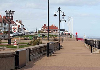
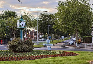
Hornsea is a seaside town and civil parish in the East Riding of Yorkshire, England. The settlement dates to at least the early medieval period. The town was expanded in the Victorian era with the coming of the Hull and Hornsea Railway in 1864. In the First World War the Mere was briefly the site of RNAS Hornsea Mere, a seaplane base. During the Second World War the town and beach was heavily fortified against invasion.

<span class="mw-page-title-main">Haltemprice</span> Area of the East Riding of Yorkshire, England

Haltemprice is an area in the East Riding of Yorkshire, England, directly to the west of Hull. Originally an extra-parochial area, it became a civil parish in 1858, in 1935 it was expanded by the combination of the urban districts of Cottingham, Anlaby, and Sculcoates to form a new urban district; the district included the villages of Anlaby, Cottingham, Hessle, Kirk Ella, Skidby, West Ella and Willerby. Urban districts were abolished 1974.

Hullshire was a county corporate in the East Riding of Yorkshire, England from 1440 to 1889. Hullshire may refer to the area outside the town of Kingston upon Hull, whilst the entire entity was sometimes referred to as the "Town and County of Kingston upon Hull".

<span class="mw-page-title-main">Hessle</span> Town and civil parish in the East Riding of Yorkshire, England

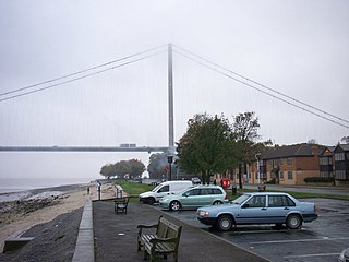
Hessle is a town, civil parish and electoral ward in the East Riding of Yorkshire, England, five miles west of Kingston upon Hull city centre. Geographically it is part of a larger urban area consisting of the city of Kingston upon Hull, the town of Hessle and a number of other villages but is not part of the city. It is on the north bank of the Humber Estuary where the Humber Bridge crosses.

<span class="mw-page-title-main">Cottingham, East Riding of Yorkshire</span> Village and civil parish in the East Riding of Yorkshire, England

Cottingham is a large village and civil parish in the East Riding of Yorkshire, England. It lies 4 miles (6 km) north-west of the centre of Kingston upon Hull, and 6 miles (10 km) south-east of Beverley on the eastern edge of the Yorkshire Wolds. It forms part of Hull's Urban Area. It has two main shopping streets, Hallgate and King Street, which cross each other near the Church of Saint Mary the Virgin, and a market square called Market Green. Cottingham had a population of 17,164 residents in 2011, making it larger by area and population than many towns. As a result, it is one of the villages claiming to be the largest village in England.

<span class="mw-page-title-main">Haltemprice and Howden (UK Parliament constituency)</span> Parliamentary constituency in the United Kingdom

Haltemprice and Howden is a constituency in the East Riding of Yorkshire represented in the House of Commons of the UK Parliament since 1997 by David Davis, a Conservative who was also Secretary of State for Exiting the European Union until his resignation from that role on 8 July 2018.

<span class="mw-page-title-main">Wressle</span> Village and civil parish in the East Riding of Yorkshire, England

Wressle is a village and civil parish in the East Riding of Yorkshire, England, lying on the eastern bank of the River Derwent approximately 3 miles (5 km) north-west of Howden.

<span class="mw-page-title-main">Anlaby with Anlaby Common</span> Civil parish in the East Riding of Yorkshire, England

Anlaby with Anlaby Common is a civil parish in the East Riding of Yorkshire, England. The parish includes the village suburb of Anlaby and the part of the area known as Anlaby Common.

<span class="mw-page-title-main">Swanland</span> Village and civil parish in the East Riding of Yorkshire, England

Swanland is a village and civil parish in the East Riding of Yorkshire in England. The village is about seven miles (11 km) to the west of Kingston upon Hull city centre and two miles (3.2 km) north of the Humber Estuary in the foothills of the Yorkshire Wolds on the B1231 road.

<span class="mw-page-title-main">Willerby, East Riding of Yorkshire</span> Village and civil parish in the East Riding of Yorkshire, England

Willerby is a village and civil parish located on the western outskirts of the city of Kingston upon Hull in the East Riding of Yorkshire, England.

<span class="mw-page-title-main">West Ella</span> Village in the East Riding of Yorkshire, England

West Ella is a small village in the civil parish of Kirk Ella west of Kirk Ella settlement, within the East Riding of Yorkshire, England, on the eastern edge of the Yorkshire Wolds, approximately 6 miles (10 km) west of the city of Kingston upon Hull.

<span class="mw-page-title-main">Anlaby</span> Village in the East Riding of Yorkshire, England

Anlaby is a village forming part of the western suburbs of Kingston upon Hull, in the East Riding of Yorkshire, England. It forms part of the civil parish of Anlaby with Anlaby Common.

<span class="mw-page-title-main">Anlaby Common</span> Suburb of Kingston upon Hull, England

Anlaby Common is former common land, now an outer suburb of Kingston upon Hull. The area includes the residential areas which are located on the western urban fringe of Hull; the B1231 road passes through all of Anlaby Common's estates, east to west.

<span class="mw-page-title-main">Newland, Kingston upon Hull</span> Area of Kingston upon Hull, East Riding of Yorkshire, England

Newland is a suburb of Kingston upon Hull, East Riding of Yorkshire, England, in the north-west of the city, a former village on the Hull to Beverley turnpike.

<span class="mw-page-title-main">Grade I listed churches in the East Riding of Yorkshire</span>

The East Riding of Yorkshire is a local government district with the status of a unitary authority. For ceremonial purposes it includes the neighbouring city and unitary authority of Kingston upon Hull.

<span class="mw-page-title-main">Southcoates</span> Area of Kingston upon Hull, East Riding of Yorkshire, England

Southcoates is an urban area in the eastern part of Kingston upon Hull, England.

<span class="mw-page-title-main">North Hull Estate</span> Area of Kingston upon Hull, East Riding of Yorkshire, England

The North Hull Estate is a residential area in the north of Kingston upon Hull, west of the River Hull, built by Hull Corporation in the interwar period.

<span class="mw-page-title-main">Dairycoates</span> Area of Kingston upon Hull in the East Riding of Yorkshire, England

Dairycoates is an area of Kingston upon Hull, East Riding of Yorkshire, England, a former hamlet.

Kingston upon Hull West and Haltemprice is a proposed constituency of the House of Commons in the UK Parliament. Further to the completion of the 2023 Periodic Review of Westminster constituencies, it will first be contested at the next general election.

<span class="mw-page-title-main">Frederick Stead Brodrick</span>

Frederick Stead Brodrick was an architect based in Kingston upon Hull, England.

References

  1. 1 2 UK Census (2011). "Local Area Report – Kirk Ella Parish (1170211299)". Nomis. Office for National Statistics . Retrieved 21 February 2018.
  2. "Home". Kirk Ella and West Ella Parish Council. Retrieved 7 February 2021.
  3. 1 2 3 4 5 6 7 Ordnance Survey 1:25000 2006
  4. 1 2 3 Ordnance Survey. Sheets 225, 239. 1852, 1855 1:10560
  5. Conservation Area Appraisal 2007, pp. 2, 5, 13.
  6. "Haltemprice and Howden". UK Polling Report. Archived from the original on 18 May 2015. Retrieved 11 May 2015.
  7. "Area: Kirk Ella (Parish)". Neighbourhood Statistics. Office for National Statistics . Retrieved 23 September 2014.
  8. "Parish Name: Kirk Ella and West Ella" (PDF). 2001 Census Area Profile. East Riding of Yorkshire Council. 2004. Archived (PDF) from the original on 18 March 2012. Retrieved 8 February 2013.
  9. UK Census (2001). "Local Area Report – Kirk Ella Parish (00FB170)". Nomis. Office for National Statistics . Retrieved 1 March 2020.
  10. 1 2 Kirk Ella in the Domesday Book
  11. Tickell 1798, p. 886.
  12. Conservation Area Appraisal 2007, p. 6.
  13. Historic England. "Monument No. 910789". Research records (formerly PastScape). Retrieved 1 September 2015.
  14. Historic England. "Monument No. 78947". Research records (formerly PastScape). Retrieved 1 September 2015.
  15. Historic England. "Monument No. 78954". Research records (formerly PastScape). Retrieved 1 September 2015.
  16. Historic England. "Monument No. 1556562". Research records (formerly PastScape). Retrieved 1 September 2015.
  17. Tickell 1798, p. 885.
  18. Historic England. "CHURCH OF SAINT ANDREW, CHURCH LANE (1103401)". National Heritage List for England . Retrieved 1 September 2015.
  19. 1 2 Pevsner & Neave 1995, pp. 584–5.
  20. 1 2 Pevsner & Neave 1995, p. 585.
  21. Historic England. "CHEST TOMB OF JANE WHITAKER ABOUT 50 METRES SOUTH WEST OF WEST TOWER OF CHURCH OF SAINT ANDREW (1309983)". National Heritage List for England . Retrieved 1 September 2015.
  22. 1 2 Allison, K. J., ed. (1969). The City of Kingston upon Hull : Boundaries. A History of the County of York East Riding. Vol. 1. The city of Kingston upon Hull. Victoria County Histories. pp. 1–10.
  23. Tickell 1798, pp. 885–6.
  24. Allison 1981, Ch. 1, pp. 3–8.
  25. Woolley, William, ed. (1830). "Chronological Table". A collection of statutes relating to the town of Kingston-upon-Hull, the county of the same town and the parish of Sculcoates. Simpkin and Marshall. pp. xi–xxviii.
  26. 1 2 3 Allison 1981, p. 30.
  27. Historic England. "4, Church Lane (1346984)". National Heritage List for England . Retrieved 1 September 2015.
  28. Historic England. "THE OLD HALL, 10, CHURCH LANE (1103402)". National Heritage List for England . Retrieved 1 September 2015.
  29. 1 2 3 4 5 Pevsner & Neave 1995, p. 586.
  30. 1 2 3 Allison 1981, p. 31.
  31. Allison 1981, pp. 31–2.
  32. Historic England. "WOLFRETON GRANGE WOLFRETON HALL (1103361)". National Heritage List for England . Retrieved 1 September 2015.
  33. Historic England. "KIRK ELLA HOUSE AND ATTACHED GARAGE (1347006)". National Heritage List for England . Retrieved 1 September 2015.
  34. Historic England. "TREVAYNE, 6, CHURCH LANE (1161637)". National Heritage List for England . Retrieved 1 September 2015.
  35. Historic England. "THE VICARAGE (1161648)". National Heritage List for England . Retrieved 1 September 2015.
  36. Historic England. "OUTBUILDING APPROXIMATELY 7 METRES NORTH WEST OF NUMBER 8 (VICARAGE) (1346985)". National Heritage List for England . Retrieved 1 September 2015.
  37. Allison 1981, p. 34.
  38. Historic England. "WOLFRETON HOUSE (1103400)". National Heritage List for England . Retrieved 1 September 2015.
  39. Historic England. "STABLE BLOCK AT WOLFRETON HOUSE (1161634)". National Heritage List for England . Retrieved 1 September 2015.
  40. Pevsner & Neave 1995, p. 587.
  41. Allison 1981, pp. 29–30.
  42. Historic England. "KIRK ELLA HALL, PACKMAN LANE (1103363)". National Heritage List for England . Retrieved 1 September 2015.
  43. Allison 1981, p. 29.
  44. Historic England. "11, PACKMAN LANE (1103362)". National Heritage List for England . Retrieved 1 September 2015.
  45. Allison 1981, p. 10.
  46. Pevsner & Neave 1995, pp. 585–586.
  47. Allison 1981, p. 27.
  48. 1 2 3 4 Bulmer 1892.
  49. See Hull and Barnsley Railway
  50. Butt, R. V. J. (October 1995). The Directory of Railway Stations: details every public and private passenger station, halt, platform and stopping place, past and present (1st ed.). Sparkford: Patrick Stephens Ltd. ISBN   978-1-85260-508-7. OCLC   60251199. OL   11956311M.
  51. Ordnance Survey. Sheet 239NE 1908
  52. Ordnance Survey. 1855 1:10560; 1888–90, 1910, 1927 1:2500
  53. "About Hull Golf Club". Hull Golf Club. Retrieved 1 September 2015.
  54. Ordnance Survey. Sheet 239NE 1926, 1938, 1948; Sheet 225SE 1926, 1938, 1946–8
  55. Ordnance Survey 1956, 1968 1:10560
  56. Ordnance Survey 1977–80 1:10000; 1971. 1976 1:2500
  57. Ordnance Survey 1994–95 1:10000
  58. "History of Wolfreton". Wolfreton School. Retrieved 3 May 2021.
  59. "Clockwise (1986)". British Film Locations. Archived from the original on 3 May 2021. Retrieved 3 May 2021.
  60. "Wolfreton School ready for 'inspiring' – and long-awaited – £22m redevelopment". Hull Daily Mail. 5 January 2015. Archived from the original on 24 September 2015. Retrieved 1 September 2015.
  61. Hawkins, John (1787). The Works of Samuel Johnson, LL. D. together with his life. Vol. 1. pp. 396–.
  62. Fairclough, Robert (2011). This Charming Man: The Life of Ian Carmichael. Aurum Press. ISBN   978-1845136642.
  63. "An address of distinction". Hull Daily Mail. 3 August 2009. Archived from the original on 24 September 2015. Retrieved 1 September 2015.
  64. "Tearful Sir Tom Courtenay says Freedom of Hull '˜nicer' than winning Golden Globe". The Yorkshire Post. 18 January 2018. Retrieved 3 May 2021.
  65. Mason, Sue (1 November 2010). "He's made millions, now he wants to give something back. Sue Mason meets Assem Allam". Hull Daily Mail. Retrieved 10 May 2016.[ permanent dead link ]
  66. Wright, Steve (8 April 2010). "Former footballer must pay back £90,000 in illegal brothel earnings". Telegraph & Argus. Retrieved 21 February 2018.
  67. "Dean Windass opens up about bankruptcy, depression and the woman he calls his 'rock'". Hull Daily Mail. 28 June 2018. Retrieved 3 May 2021.
  68. "How Isy made her mark in the tough world of comedy". This Is Derbyshire. 1 June 2012. Archived from the original on 25 September 2013. Retrieved 14 September 2012.
  69. "Hannah John-Kamen to star in Spice Girls musical". This Is Hull and East Riding. 3 October 2012. Archived from the original on 26 September 2013. Retrieved 24 January 2021.

Sources