Kirksville Regional Airport

Last updated
Kirksville Regional Airport
IRK logo.png
Summary
Airport typePublic
OwnerCity of Kirksville
Serves Kirksville, Missouri
Location Pettis Township, near Millard
Elevation  AMSL 966 ft / 294 m
Coordinates 40°05′36″N092°32′42″W / 40.09333°N 92.54500°W / 40.09333; -92.54500
Website
Map
USA Missouri relief location map.svg
Airplane silhouette.svg
IRK
Usa edcp relief location map.png
Airplane silhouette.svg
IRK
Runways
Direction LengthSurface
ftm
18/366,0051,830Concrete
9/271,370418Turf
Statistics (2023)
Aircraft operations (year ending 4/30/2023)5,888
Based aircraft20

Kirksville Regional Airport( IATA : IRK, ICAO : KIRK, FAA LID : IRK) is four miles south of Kirksville, Missouri, [1] on the west side of US highway 63. [2] One airline schedules passenger flights, subsidized by the Essential Air Service program.

Contents

Federal Aviation Administration records say the airport had 684 passenger boardings (enplanements) in calendar year 2008, [3] 926 in 2009 and 2,127 in 2010. [4] The National Plan of Integrated Airport Systems for 2011–2015 categorized it as a general aviation facility (the commercial service category requires at least 2,500 enplanements per year). [5]

Cape Air is the current airline, averaging 900 to 1,000 passengers per month [6] on three daily round trips to St. Louis Lambert International Airport. [7] After Cape Air notified the city in November 2022 of their plans to terminate their service, the Kirksville City Council approved a contract on February 6, 2023 with Contour Airlines, with service beginning in June to Chicago O'Hare International Airport. [8]

Clarence Cannon Memorial Terminal at Kirksville Regional Airport. Kirksville Regional Airport 1.jpg
Clarence Cannon Memorial Terminal at Kirksville Regional Airport.

History

Local resident Nick Sparling is credited as being Adair County's first aviator, in 1909.[ citation needed ] In 1924, Roy B. "Cap" Dodson started the first airport in the area, located on the north edge of Kirksville.[ citation needed ] However, an airfield at the present location of Kirksville Regional Airport wasn't created until 1930 when the Federal Aviation Administration built a series of emergency landing strips across the nation. With America's entry into World War II, the Kirksville Municipal Airport, as it had been declared in the late 1930s, received a major upgrade from the Civilian Pilots Training Program and the US Army Air Corps War Training Service.[ citation needed ] In 1942 a paved all-weather landing strip, hangars, a control tower and small restaurant were built; the paved runway was 3870 ft until 1968.[ citation needed ]

In 1960, Ozark Air Lines began scheduled flights.[ citation needed ] The Ozark route began in Kansas City to Chicago with stops in Kirksville, Ottumwa, Cedar Rapids, Iowa and Moline, Illinois.[ citation needed ] Airport improvements came after a bond issue was approved by Kirksville voters in 1967. A new six-thousand foot concrete runway was built, as well as a new terminal building and improved hangar facilities. The longer runway was needed for the faster Fairchild prop-jet that began flights to Kirksville in late 1968.[ citation needed ] Also in the 1960s, Ozark switched Kirksville service from a Kansas City-Chicago route to a Des Moines-to-St. Louis one. With the airport improvements came a new name, Clarence Cannon Memorial Airport—chosen to honor long-time US Congressman Clarence Cannon of Missouri who had done much to help secure air service and funding for the airport.[ citation needed ]

Ozark Airlines found flew their final route on April 23, 1976.[ citation needed ] Fortunately a local pilot and dentist, Dr. Stephen Barber, has established a small commuter air service, Horizon Airways, in 1972.[ citation needed ] Horizon was able to help fill the void left by Ozarks departure, eventually expanding to five aircraft and service to both Kansas City and St. Louis. [9] [10]

Air Choice One began scheduled flight operations twice daily, to and from Lambert-St. Louis International Airport during July 2009.[ citation needed ] Scheduled operations are currently subsidized by the Essential Air Service Act. Previously service was operated by Air Midwest (operating as US Airways Express) to Kansas City International Airport [11] and by RegionsAir (operating as American Connection) with flights to Lambert-St. Louis International Airport. In September, 2010 Cape Air replaced Air Choice One.[ citation needed ]

In November 2022, Cape Air notified Kirksville of their plans to terminate service. However, the airline was still required to continue their flights until the city selected a replacement. The Kirksville City Council approved a contract on February 6, 2023 with Contour Airlines, with 12 flights per week beginning in June to Chicago O'Hare International Airport. [12]

Facilities

The airport covers 476 acres (193 ha) at an elevation of 966 feet (294 m). It has two runways: 18/36 is 6,005 by 100 feet (1,830 x 30 m) concrete; 9/27 is 1,370 by 100 feet (418 x 30 m) turf. [1]

In the year ending April 30, 2023 the airport had 5,888 aircraft operations, average 113 per week: 50% general aviation, 37% airline, 12% air taxi, and <1% military. 20 aircraft were then based at the airport: 17 single-engine, 2 multi-engine, and 1 jet. [1]

Airline and destination

AirlinesDestinationsRefs.
Contour Airlines Chicago–O'Hare [13]

Incidents

See also

Related Research Articles

<span class="mw-page-title-main">Manhattan Regional Airport</span> Airport

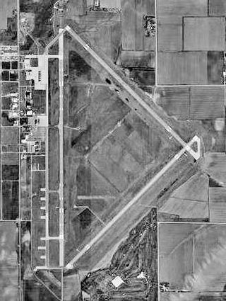
Manhattan Regional Airport in Riley County, Kansas, United States, is the second-busiest commercial airport in Kansas. Owned by the city of Manhattan, Kansas,the airport is located about five miles southwest of downtown Manhattan. American Airlines serves the airport with five daily flights to Chicago O'Hare International Airport and Dallas/Fort Worth International Airport.The airport also accommodates general aviation and charter planes for the military and college sports teams, being conveniently located four miles east of Fort Riley and eight miles southwest of Kansas State University's athletic complex).

<span class="mw-page-title-main">Central Nebraska Regional Airport</span> Airport in Nebraska

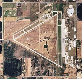
Central Nebraska Regional Airport is three miles northeast of Grand Island, in Hall County, Nebraska. It is owned by the Hall County Airport Authority. The airport sees two airlines, Allegiant Air which flies independently and American Eagle which is subsidized by the federal Essential Air Service program. In 2016 the airport had 68,879 passenger boardings (enplanements), a 6.6% increase from the 64,602 enplanements in 2015. The airport had 7,961 enplanements in calendar year 2008, 20,136 in 2009 and 37,101 in 2010.

<span class="mw-page-title-main">Great Bend Municipal Airport</span> Airport

Great Bend Municipal Airport is five miles west of Great Bend, in Barton County, Kansas. It is used for general aviation and formerly saw one airline, subsidized by the Essential Air Service program.

<span class="mw-page-title-main">Columbia Regional Airport</span> Airport in Missouri, United States of America

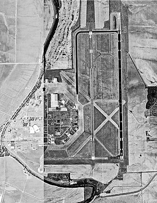
Columbia Regional Airport is a commercial passenger airport serving Columbia, Missouri. Located about 12 miles (19 km) southeast of Columbia in Boone County, Missouri, it is the only commercial airport in Mid-Missouri and also serves the state capital of Jefferson City. As of 2022, commercial passenger service is provided by American Airlines subsidiary American Eagle. The airport opened in 1968, replacing the Columbia Municipal Airport off of Interstate 70. It is frequently used for charter flights by college athletic teams visiting the University of Missouri and for MU team flights.

<span class="mw-page-title-main">Joplin Regional Airport</span> Airport

Joplin Regional Airport is located four miles (6.4 km) north of Joplin, in Jasper County, Missouri, United States. It has airline service, which is subsidized by the Essential Air Service program.

<span class="mw-page-title-main">Barkley Regional Airport</span> Airport

Barkley Regional Airport is an American domestic airport in West Paducah, Kentucky, 14 miles west of Paducah in McCracken County. It is used for general aviation and sees one airline, subsidized by the Essential Air Service program.

<span class="mw-page-title-main">Greenville Mid-Delta Airport</span> Airport

Greenville Mid-Delta Airport, operating as Mid Delta Regional Airport until 2011, is a public use airport in unincorporated Washington County, Mississippi, United States. It is located five nautical miles northeast of the central business district of Greenville, the city that owns the airport. It is served by one commercial airline, Contour Airlines, which is subsidized by the Essential Air Service program. Formerly, the facility was known as Greenville Air Force Base.

Athens–Ben Epps Airport is a county-owned, public-use airport located three nautical miles (6 km) east of the central business district of Athens, a city in Clarke County, Georgia, United States. The airport is named after Ben T. Epps, the first aviator in the state of Georgia, who opened the airport in 1917. It is mostly used for general aviation, though it was formerly served by one commercial airline with scheduled passenger service subsidized by the Essential Air Service program.

<span class="mw-page-title-main">North Central West Virginia Airport</span> Airport in West Virginia, United States

North Central West Virginia Airport is a public/military airport a mile northeast of Bridgeport and six miles east of Clarksburg, in Harrison County, West Virginia, United States. It is owned and operated by the Benedum Airport Authority, serving Harrison and Marion County, and was formerly Benedum Airport and Harrison-Marion Regional Airport. The airport sees two airlines, with some passenger service subsidized by the Essential Air Service program.

Greenbrier Valley Airport is three miles north of Lewisburg in Greenbrier County, West Virginia. Contour Airlines schedules airline flights, subsidized by the Essential Air Service program, to Charlotte Douglas International Airport. Federal Aviation Administration records say the airport had 10,902 passenger boardings (enplanements) in calendar year 2021 and 10,048 in 2022. The National Plan of Integrated Airport Systems for 2023–2027 called it a primary commercial service airport based on enplanements in 2021.

DuBois Regional Airport, formerly DuBois–Jefferson County Airport, is in Jefferson County, Pennsylvania, eight miles northwest of DuBois, a city in Clearfield County. The airport is in Washington Township. It is owned and operated by the Clearfield-Jefferson Counties Regional Airport Authority, based at the airport. It has scheduled service on one airline, Southern Airways Express, subsidized by the Essential Air Service program.

<span class="mw-page-title-main">Johnstown–Cambria County Airport</span> Airport

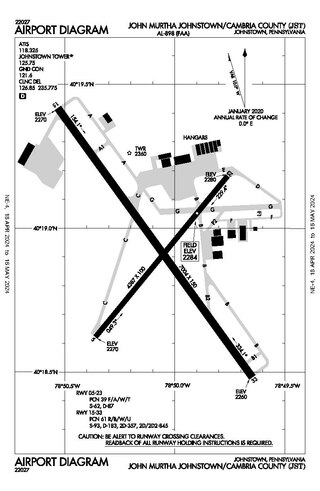
John Murtha Johnstown–Cambria County Airport is a civil-military airport three miles (5 km) northeast of Johnstown, in Cambria County, Pennsylvania. It is owned by Johnstown–Cambria County Airport Authority and is named after the late Congressman John Murtha. It sees one airline, subsidized by the Essential Air Service.

<span class="mw-page-title-main">Quincy Regional Airport</span> Airport serving Quincy, Illinois, United States

Quincy Regional Airport is a city-owned airport 12 miles east of Quincy, a city in Adams County, Illinois, United States. It is used for general aviation but also sees Southern Airways Express flights to Chicago's O'Hare International Airport and St. Louis Lambert International Airport, a service which is subsidized by the federal government's Essential Air Service program at a cost of $1,956,856. The Federal Aviation Administration (FAA) National Plan of Integrated Airport Systems for 2023–2027 categorized it as a national non-primary commercial service facility.

<span class="mw-page-title-main">Veterans Airport of Southern Illinois</span> Airport

Veterans Airport of Southern Illinois , also known as Williamson County Regional Airport, is five miles west of Marion, in Williamson County, Illinois, United States. The airport is owned by the Williamson County Airport Authority. It sees one airline, subsidized by the federal government's Essential Air Service program at an annual cost of $2,562,819 or $141 per passenger. On November 11, 2016 during the grand opening ceremony for the new terminal, the airport was renamed to "Veterans Airport of Southern Illinois" to honor veterans and better reflect the regional nature of the airport.

<span class="mw-page-title-main">McKellar–Sipes Regional Airport</span> Airport in Madison County, Tennessee

McKellar–Sipes Regional Airport is a public use airport located four nautical miles (7 km) west of the central business district of Jackson, a city in Madison County, Tennessee, United States. It is owned by the city and county. The airport is mostly used for general aviation, and is served by one commercial airline, Southern Airways Express, subsidized by the Essential Air Service program.

<span class="mw-page-title-main">Owensboro–Daviess County Regional Airport</span> Small airport in Kentucky

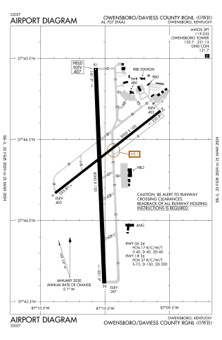
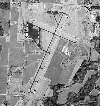
Owensboro–Daviess County Airport is a public use airport located three miles southwest of Owensboro, in Daviess County, Kentucky. The airport is owned by both the city and county. One airline schedules passenger flights, subsidized by the Essential Air Service program.

<span class="mw-page-title-main">Tupelo Regional Airport</span> Airport

Tupelo Regional Airport is a public use airport located 3.7 miles; 3.2 nautical miles (6 km) west of the central business district of Tupelo, a city in Lee County, Mississippi, United States. It is owned by the Tupelo Airport Authority. The airport is mostly used for general aviation, but is also served by one commercial airline with scheduled passenger service subsidized by the federal Essential Air Service (EAS) program. Many college football teams visiting the University of Mississippi, 49 miles west in Oxford, fly into Tupelo.

<span class="mw-page-title-main">Unalaska Airport</span> Airport in Amaknak Island

Tom Madsen Airport is a state-owned public-use airport in City of Unalaska, on Amaknak Island in the Aleutian Islands, off the coast of the U.S. state of Alaska. It is located near the Bering Sea coast of Unalaska Island, 800 miles (1,300 km) southwest of Anchorage and 1,950 miles (3,140 km) from Seattle.

<span class="mw-page-title-main">Canyonlands Regional Airport</span> Regional airstrip near Moab, Utah, United States

Canyonlands Regional Airport, Moab is a regional commercial airport in Grand County, Utah, United States, 21 miles (34 km) northwest of Moab. The airport services two airlines, one subsidized by the Essential Air Service program.

<span class="mw-page-title-main">Vernal Regional Airport</span> Airport

Vernal Regional Airport is a mile southeast of Vernal, in Uintah County, Utah. It is owned by the city and county and sees one airline, subsidized by the Essential Air Service program.

References

  1. 1 2 3 4 FAA Airport Form 5010 for IRK PDF . Federal Aviation Administration. Effective August 10, 2023.
  2. "General Aviation - City of Kirksville, Missouri".
  3. "Enplanements for CY 2008" (PDF, 1.0 MB). CY 2008 Passenger Boarding and All-Cargo Data. Federal Aviation Administration. December 18, 2009.
  4. "Enplanements for CY 2010" (PDF, 189 KB). CY 2010 Passenger Boarding and All-Cargo Data. Federal Aviation Administration. October 4, 2011.
  5. "2011–2015 NPIAS Report, Appendix A" (PDF). National Plan of Integrated Airport Systems. Federal Aviation Administration. October 4, 2010. Archived from the original (PDF, 2.03 MB) on September 27, 2012.
  6. Garlock, John (May 11, 2012). "Kirksville airport to embark on expensive improvements". KTVO-TV via website. Retrieved May 12, 2012.
  7. "Kirksville Regional Airport-Cape Air schedule". City of Kirksville website. Archived from the original on May 11, 2012. Retrieved May 12, 2012.
  8. Bachman, Marty (February 12, 2023). "Kirksville City Council approves Contour Airlines as new Essential Air Service provider for Kirksville Airport". Kirksville Daily Express via website. Retrieved March 15, 2023.
  9. A History Of Adair County Missouri published by the Kirksville-Adair County Bicentennial Committee, 1976.
  10. 'Flying High!' by Tony Frost & Corey Pritchard, published in The Chariton Collector magazine Spring, 1987.
  11. "Mesa Air Group Announces Schedule and Fares for Kirksville, Missouri as US Airways Express". Press Release. Mesa Air Group. October 13, 2006.
  12. Bachman, Marty (February 12, 2023). "Kirksville City Council approves Contour Airlines as new Essential Air Service provider for Kirksville Airport". Kirksville Daily Express via website. Retrieved March 15, 2023.
  13. "Contour Airlines August 2023 Chicago Network Expansion". Aeroroutes. Retrieved 9 June 2023.
  14. "Aircraft Accident Report: Collision with Trees and Crash Short of Runway, Corporate Airlines Flight 5966, British Aerospaaace BAE-J3201, N875JX, Kirksville, Missouri, October 19, 2004". National Transportation Safety Board. 2006-01-24.
  15. "Poor Behavior, Fatigue Led to '04 Plane Crash". Washington Post. 2006-01-25.
  16. Ranter, Harro. "Incident Boeing 717-200 N910ME, 12 May 2005". aviation-safety.net. Retrieved 2021-11-24.
  17. Hunsicker, Jason (6 November 2013). "Plane crash victims were business owner, flight instructor". Kirksville Daily Express. Retrieved 7 November 2013.

Other sources