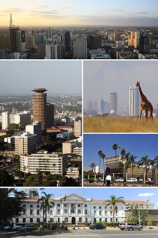
Nairobi is the capital and largest city of Kenya. The name is derived from the Maasai phrase Enkare Nairobi, which translates to 'place of cool waters', a reference to the Nairobi River which flows through the city. The city proper had a population of 4,397,073 in the 2019 census. The city is commonly referred to as The Green City in the Sun.
Nairobi National Park is a national park in Kenya that was established in 1946 about 7 km (4.3 mi) south of Nairobi. It is fenced on three sides, whereas the open southern boundary allows migrating wildlife to move between the park and the adjacent Kitengela plains. Herbivores gather in the park during the dry season. Nairobi National Park is negatively affected by increasing human and livestock populations, changing land use and poaching of wildlife. Despite its proximity to the city and its relative small size, it boasts a large and varied wildlife population, and is one of Kenya's most successful rhinoceros sanctuaries.

Arusha Region is one of Tanzania's 31 administrative regions and is located in the northeast of the country. The region's capital and largest city is the city of Arusha. The region is bordered by Kajiado County and Narok County in Kenya to the north, the Kilimanjaro Region to the east, the Manyara and Singida Regions to the south, and the Mara and Simiyu regions to the west. Arusha Region is home to Ngorongoro Conservation Area, a UNESCO World Heritage Site. The region is comparable in size to the combined land and water areas of the state of Maryland in the United States.
Thika is an industrial town and commerce hub in Kiambu County, Kenya, lying on the A2 road 42 kilometres (26 mi), northeast of Nairobi, near the confluence of the Thika and Chania Rivers. Although Thika town is administratively in Kiambu County, the greater Thika area comprising residential areas such as Bendor estate, Maporomoko, Thika Greens, Thika Golden Pearl, Bahati Ridge, and Thika Sports Club, among others, are within Murang'a County. Thika has a population of 279,429 which is growing rapidly, as is the entire greater Nairobi area. Its elevation is approximately 1,631 metres (5,351 ft).

Ruiru is a municipality and sub-county in Kiambu County, Kenya. It sits within the greater Nairobi Metropolitan region. According to the 2019 national population census, Ruiru is the 4th largest urban centre in Kenya by population. The name Ruiru is of the Kikuyu dialect and possibly relates to the black cotton soil that is found in most parts of Ruiru to the east and south.

Athi River is a town outside Nairobi, Kenya in Machakos County. The town is named after the Athi River, which passes through. It is also known as Mavoko.
Kajiado is a town in Kajiado County, Kenya. The town is located 80 km (49.7 mi) south of Nairobi, along the Nairobi – Arusha highway. Kajiado has an urban population of 24,678. Local people are predominantly of the Maasai tribe.

Kiambu County is a county in the former Central Province of Kenya. Its capital is Kiambu and its largest town is Thika town. Kiambu County is the second most populous county in Kenya after Nairobi County. Kiambu County borders Nairobi and Kajiado Counties to the South, Machakos to the East, Murang'a to the North and North East, Nyandarua to the North West, and Nakuru to the West. It has a population of 2,417,735.

Kajiado County is a county in the former Rift Valley Province of Kenya. As of 2019, Kajiado county spanned an area of 21,292.7 km2, with a recorded population of 1,117,840. The county borders Nairobi and to its south it borders the Tanzanian regions of Arusha and Kilimanjaro. The county capital is Kajiado, but the largest town is Ongata Rongai. Its main tourist attraction is its wildlife.

Ngong is a town near the Ngong Hills along the Great Rift Valley within Kajiado County, located in the southwest of Nairobi, in southern Kenya. The word "Ngong" is a Maasai word derived from the word "enkong'u" meaning both "the 'eye'" and "eye of water" or thus spring of water. The original place name is ɛnkɔŋʉ́ ɛ́ mʉny, literally the eye of the rhinoceros but functionally Rhinoceros Spring; an alternative name is ɔlchɔ́rrɔ ɛ́ mʉny (olchorro is a synonymn of enkong'u. Ngong is the anglicization of ɛnkɔŋʉ́. Seemingly the British found enkong'u e muñ too difficult to pronounce. A widespread false etymology is linked with the knuckle shape of the hills.

Isinya is a town in Kajiado County, Kenya. Isinya, located at -1.67 latitude, 36.85 longitude, is 58 km south of Nairobi and 19 km north of Kajiado, the capital of the district.
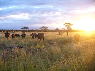
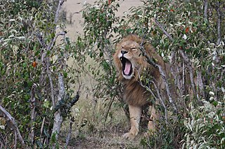
The wildlife of Kenya refers to its fauna. The diversity of Kenya's wildlife has garnered international fame, especially for its populations of large mammals. Mammal species include lion, cheetah hippopotamus, African buffalo, wildebeest (Connochaetes), African bush elephant, zebra (Equus), giraffe (Giraffa), and rhinoceros. Kenya has a very diverse population of birds, including flamingo and common ostrich.
South B is the name of a Division of the sub-county of Starehe in Nairobi, Kenya and the name of a "sub-location" of Mukuru Nyayo within the Division. The 2019 Kenya Census gives a population of 102,441 for South B Division and 34,216 for the sub-location. South B is about 3 kilometres (1.9 mi) south-east of Nairobi Central Business District; the Industrial Area lies to the east and the South C district to the south-west.
Kamulu is a neighbourhood in Nairobi City County located to the North East of the Nairobi Central Business District (CBD). It borders Joska (Matungulu) in Machakos County to the east, Mwalimu Farm Ruiru to the north, Njiru to the west, and Mihang'o to the south west.

Kiserian is a town in Kenya's Rift Valley Province, Kajiado County. Kiserian Town is bordered by Ongata Rongai, Ngong Town, Enoomatasiani Town and Kisamis Town. It is located on the boundary between Kajiado North and Kajiado West constituencies. It lies at the foot of the Ngong Hills, along Magadi Road just adjacent to the Kiserian dam. There is a famous Maasai community around Kiserian town and small Maasai villages called Olteyani and Olooseos. Among other social amenities, Kiserian has several primary schools and secondary schools, and a few higher education institutions. In the language of the Maasai, Kiserian means "a place of peace".
Ongata Rongai is a town located in Kajiado North, Kajiado County, Kenya. The town is situated 17 km (10.6 mi) south of the Nairobi CBD, East of the Ngong hills, and within the greater Nairobi Metropolitan Region. It lies 1,731 meters (5,682 feet) above sea level. According to the 2019 Census, it is the most populous town in Kajiado County and eleventh largest urban centre by population in Kenya.
Konza Technopolis, previously called Konza Technology City, is a large technology hub planned by the government of Kenya to be built 64 km south of Nairobi on the way to the port city of Mombasa. It is marketed as a key driver of Kenya's national development plan, known as Kenya Vision 2030. As of January 2019, the project appeared to be far behind schedule.
Kajiado District was an administrative district in the Rift Valley Province of Kenya. It had a population of 406,054 and an area of 21,903 km². The district bordered Nairobi region and extended to the Kenya-Tanzania border further south. The district capital was Kajiado.
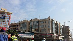
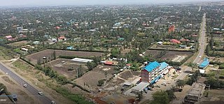
The real estate sector in Kenya has seen a boom that began somewhere in the mid to late 2000s because the property market is responding to increased demand.