Kittanning Path

Last updated
USGS combined Topo and relief map image of the Kittanning Point promontory looming above and overshadowing the valley and streams below, directly west and above the confluence of Kittanning Run (denoted by the yellow circle labeled 'A') and Glenwhite Run (the major right branch stream to the north of the reservoirs).
Foot travelers could follow either large stream or the smaller stream in the Kittanning Gap (lower down, at image right), or one of the several gaps of the Allegheny (to the south of this view) which were exploited by the Allegheny Portage Railroad or the Penn Central Railroad. Mule trains of Trappers could take steeper ravines than westward migrating white settlers with animal power towed vehicles such as Wagons and carts.
Each 'gap of the Allegheny Front' was one likely road for Amerindian and fur traders foot traffic to cross the Allegheny Front into the Allegheny Valley and reach the native settlement at Kittanning Village or beyond. Various gaps climb faster (steeper) or slower to the highland 700-900 feet (210-270 m) above.
The terrains above the front are part of the Appalachian Plateau, which presents as a larger-than-county sized region of low hills and small creeks, topped by the eastern continental divide. USGS National Map viewer showing Kittanning Run, Pennsylvania location near Altoona--MIxed Mode topo+Sat.png
USGS combined Topo and relief map image of the Kittanning Point promontory looming above and overshadowing the valley and streams below, directly west and above the confluence of Kittanning Run (denoted by the yellow circle labeled 'A') and Glenwhite Run (the major right branch stream to the north of the reservoirs).
Location of Kittanning Gap after GNIS finding of 'Kittanning Gap, Pennsylvania' seen in USGS National Map viewer screenshot. The gap is located effectively in a western suburb of Altoona, PA.
The maps on this page also are showing the nearby PRR Horseshoe Curve, which crosses three other gaps, and the confluence of Kittanning Run with Glen White Run, which descends running nearly due west to east.
The Kittanning Gap gives this 'choice way' of climbing the escarpment to wagons or mule trains on the way to the west side of the Allegheny Mountains and Kittanning, PA along the Kittanning Path. Taking a right through the gap to climb above the escarpment by a circuitous route following a traverse across contours climbing the sides of slopes was longer, but quite a bit easier than attempting to pull farm wagons or Conestoga wagons up either of the steep narrow creek bed straight ahead... or some of the other gaps of the Allegheny Front. USGS overview indicating Kittanning Gap's, Pennsylvania location near Altoona, PA and showing the PRR Horseshoe Curve.png
Location of Kittanning Gap after GNIS finding of 'Kittanning Gap, Pennsylvania' seen in USGS National Map viewer screenshot. The gap is located effectively in a western suburb of Altoona, PA.
  • The maps on this page also are showing the nearby PRR Horseshoe Curve, which crosses three other gaps, and the confluence of Kittanning Run with Glen White Run, which descends running nearly due west to east.
  • The Kittanning Gap gives this 'choice way' of climbing the escarpment to wagons or mule trains on the way to the west side of the Allegheny Mountains and Kittanning, PA along the Kittanning Path. Taking a right through the gap to climb above the escarpment by a circuitous route following a traverse across contours climbing the sides of slopes was longer, but quite a bit easier than attempting to pull farm wagons or Conestoga wagons up either of the steep narrow creek bed straight ahead... or some of the other gaps of the Allegheny Front.

The Kittanning Path was a major east-west Native American trail that crossed the Allegheny Mountains barrier ridge connecting the Susquehanna River valleys in the center of Pennsylvania to the highlands of the Appalachian Plateau and thence to the western lands beyond drained by the Ohio River. Kittanning Village was the first major Delaware (Lenape) Indian settlement along the descent from the Allegheny Plateau.

Contents

Nature and the path

The path is made up of a "series of path alternatives" that pass through seasonally or directionally more or less difficult notches [lower-alpha 1] the gaps were among only five places that could be crossed by animal power from east to west across the Appalachian Mountains west of New England. The Kittanny path (by other names [lower-alpha 2] ) would also come to be used first by Dutch, then English and British colonial fur traders, as well as Amerindian emigrants moving westwards before and after the French and Indian War and in the post-1780 [lower-alpha 3] settlers migrations west of the Mountain as the American Revolution entered its final years.

For centuries the Kittanning Path, like the similar Chief Nemacolin's Trail to the south, was the overland route through very tough country [lower-alpha 4] for Native American peoples. They included Iroquoian-speaking tribes, such as the Erie, Susquehannock, and the Five Nations of the Iroquois confederacy, as well as the Algonquian-speaking Lenape, Miami, and Siouan Shawnee. Early European explorers and settlers also learned to use the Indian paths to cross the Allegheny Mountains barrier ridge.

The path made use of one of the few so-called gaps of the Allegheny that accompanied the feedwater streams draining into the Juniata River, a tributary of the Susquehanna that terminated on the Allegheny River due Northeast of Pittsburgh in what is now Armstrong County, Pennsylvania at the Native American Kittanning Village (at present-day Kittanning, Pennsylvania).

By the time of the French and Indian War, starting in 1754, Kittanning Village was believed by Europeans to be the largest Native American village in the Ohio Country west of the Alleghenies.[ citation needed ] It was located in an area of Pennsylvania that had been closed to white settlement by the original treaty of William Penn with the Lenape.

In an attempt to settle frontier borders and reduce conflict among Indian tribes, the English and Native Americans signed the Treaty of Fort Stanwix after the French and Indian War. It opened some of Pennsylvania west of the Alleghenies to white settlement. [1] In the 1750s, this area had been the scene of a fierce raids by Native Americans against white settlement, and a major British retribution campaign.

A section of the original path is preserved in northwestern Cambria County.

Description (East to West)

It began southeast of Altoona at Frankstown on the Juniata River. It ran west, crossing the Allegheny Ridge approximately 5 mi (8 km) west of Altoona at Kittanning Gap, later the location of the Horseshoe Curve railroad site.

The path ran northwest through Cambria County, passing east of Carrolltown. It entered Indiana County approximately 1 mi (1.6 km) south of Cherry Tree at "Canoe Place", the uppermost Native American canoe portage on the West Branch of the Susquehanna.

It followed a southwest course, through Yellow Creek State Park, then along the headwaters of Two Lick Creek, roughly past Uniontown, Pennsylvania (not the current Uniontown), Cookport, and Diamondville to U.S. Highway 422. It followed the approximate present course of the highway west and NNW through Indiana to Shelocta. It crossed into Armstrong County near Elderton and ended at the village of Kittanning on the east bank of the Allegheny.

History

The path was in use as early as 1721. In 1744 the English trader John Hart was granted a license by colonial authorities to trade with the Indians in western Pennsylvania lands, which were then closed to white settlement. Hart established a way station campsite, called Hart's Sleeping Place, near the continental divide in Cambria County. The way station appeared on colonial maps and was used in 1752 by Gov. James Hamilton, and in 1754 by John Harris, the founder of Harrisburg. The last Native American encampment was recorded at the site in 1781.

In the 1750s the path became the raiding route taken by Lenape. Unhappy with a treaty that took away much of their land rights in western Pennsylvania, they raided white settlements in central Pennsylvania. In 1755, the Lenape chief Shingas used the trail to attack British settlements along the Juniata River, returning with captives to the village of Kittanning. In early August 1756, the Lenape used the path for a raid to burn Fort Granville near present-day Lewistown, when they also took prisoners.

After the fort was burned, the British dispatched Lt. Colonel John Armstrong for retaliation. He pursued the Lenape along the path and camped at Canoe Place in early September; he continued to the village of Kittanning, which he destroyed on 8 September. Armstrong earned the accolade among British colonials as "the Hero of Kittanning" for the raid. He later served as a Major General for the United States in the American Revolutionary War and was elected to the Second Continental Congress.

The path was also traveled by early German pioneer Conrad Weiser, who was accompanied by William Franklin, the son of Benjamin Franklin. Weiser recorded the journey in his journal.

The Kittanning Path is not to be confused with the Kittanning Road, which was built by American rebel forces in 1779 during the Sullivan Expedition. The Kittanning Road followed a more northerly course, running from Kittanning to the site of what is now Olean, New York.

Preservation

The trail has been surveyed by historians through Cambria County. An authentic section of the original trail is preserved near Eckenrode Mill east of Carrolltown.

See also

Notes

  1. a succession of water gap valleys in the same upland region known as the gaps of the Allegheny cut in the edge of the plateau by the small streams which gather hundreds of feet below into tributary brooks of the West Branch Susquehanna River.
  2. The name of the Kittanny Path would be shaped as British colonials encroached on remnant eastern coastal Indian tribes, resulting in a westward migration of the Delaware people across the heartland of their vanished rival, the Susquehannock, into the west beyond the Alleghenies. This area had been emptied of tribes by internecine Amerindian wars prior to the advent of the first Dutch and French traders and explorers to enter the continent (after 1600). By the time of the 1750s, leading into the French and Indian War, the Kittany path had supported a westward migration of Delaware peoples for decades. One of their major towns west of the Appalachian ridge was known as Kittanning Village by whites, who gradually called these routes the Kittanning Path.
  3. The Sullivan Expedition (1779) broke the power of the Iroquois, who had previously defeated the power of the few remaining non-Iroquois in the Allegheny and upper Ohio valleys. Some Colonials had moved west even before the war, and the migration increased after the Revolution.
  4. These heavily forested mountains were virgin stands of mostly hardwoods, with trunk diameters starting above 34 in (86 cm)&mdash. Such girths are rarely seen in trees in the 21st century outside deep wilderness. In the 1600s-1840s the Appalachians were covered by such trees from upstate Maine to Northern Georgia.

Related Research Articles

<span class="mw-page-title-main">Allegheny River</span> River in Pennsylvania and New York, United States

The Allegheny River is a 325-mile-long (523 km) headwater stream of the Ohio River that is located in western Pennsylvania and New York in the United States. It runs from its headwaters just below the middle of Pennsylvania's northern border, northwesterly into New York, then in a zigzag southwesterly across the border and through Western Pennsylvania to join the Monongahela River at the Forks of the Ohio at Point State Park in Downtown Pittsburgh, Pennsylvania.

<span class="mw-page-title-main">Armstrong County, Pennsylvania</span> County in Pennsylvania, United States

Armstrong County is a county in the Commonwealth of Pennsylvania. As of the 2020 census, the population was 65,558. The county seat is Kittanning. The county was organized on March 12, 1800, from parts of Allegheny, Westmoreland and Lycoming Counties. It was named in honor of John Armstrong, who represented Pennsylvania in the Continental Congress and served as a major general during the Revolutionary War.

<span class="mw-page-title-main">Gallitzin, Pennsylvania</span> Borough in Pennsylvania, United States

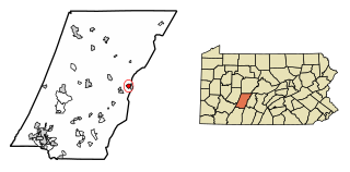
Gallitzin is a borough in Cambria County, Pennsylvania, United States. It is bordered by Gallitzin Township and Tunnelhill, all of which sit astride the Eastern continental divide. Tunnel Hill and Gallitzin both are pierced by railroad tunnels shortening the necessary ascent for rails crossing the Allegheny Front onto the Allegheny Plateau which encompasses the towns' terrains. Topping the gaps of the Allegheny, the area is one of only five major breaks in the Appalachians allowing east–west transportation corridors before the advent of 20th century technologies.

<span class="mw-page-title-main">Susquehanna River</span> Major river in the Northeastern United States

The Susquehanna River is a major river located in the Mid-Atlantic region of the United States, overlapping between the lower Northeast. At 444 miles (715 km) long, it is the longest river on the East Coast of the United States. By watershed area, it is the 16th-largest river in the United States, and also the longest river in the early 21st-century continental United States without commercial boat traffic.

<span class="mw-page-title-main">Ohio Country</span> Historical region in North America

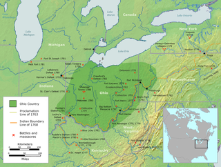
The Ohio Country, was a name used before 1787 for a region of North America west of the Appalachian Mountains, north of the upper Ohio and Allegheny rivers, and extending to Lake Erie. The area encompassed present-day northwestern West Virginia, Western Pennsylvania, most of Ohio, and a wedge of southeastern Indiana.

<span class="mw-page-title-main">Kittanning (village)</span> Historic Native American village in Pennsylvania

Kittanning was an 18th-century Native American village in the Ohio Country, located on the Allegheny River at present-day Kittanning, Pennsylvania. The village was at the western terminus of the Kittanning Path, an Indian trail that provided a route across the Alleghenies between the Ohio and Susquehanna river basins.

<span class="mw-page-title-main">Juniata River</span> River in Pennsylvania, United States

The Juniata River is a tributary of the Susquehanna River, approximately 104 miles (167 km) long, in central Pennsylvania. The river is considered scenic along much of its route, having a broad and shallow course passing through several mountain ridges and steeply lined water gaps. It formed an early 18th-century frontier region in Pennsylvania and was the site of French-allied Native American attacks against English colonial settlements during the French and Indian War.

<span class="mw-page-title-main">West Branch Susquehanna River</span> River in Pennsylvania, United States

The West Branch Susquehanna River is one of the two principal branches, along with the North Branch, of the Susquehanna River in the Northeastern United States. The North Branch, which rises in upstate New York, is generally regarded as the extension of the main branch, with the shorter West Branch being its principal tributary.

<span class="mw-page-title-main">Shamokin (village)</span> Historic Native American village in Pennsylvania

Shamokin was a multi-ethnic Native American trading village on the Susquehanna River, located partially within the limits of the modern cities of Sunbury and Shamokin Dam, Pennsylvania. It should not be confused with present-day Shamokin, Pennsylvania, located to the east. The village was the focus of missionary efforts, and then was the staging area for raids on English settlements in Pennsylvania during the French and Indian War. It was burned and abandoned by the Lenape in May, 1756. A few months later, Fort Augusta was constructed on the site of the village.

<span class="mw-page-title-main">Great Shamokin Path</span>

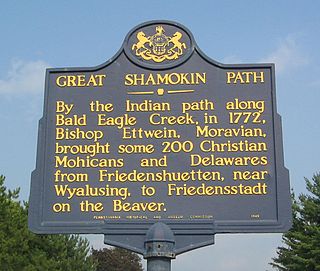
The Great Shamokin Path was a major Native American trail in the U.S. State of Pennsylvania that ran from the native village of Shamokin along the left bank of the West Branch Susquehanna River north and then west to the Great Island. There it left the river and continued further west to Chinklacamoose and finally Kittanning on the Allegheny River.

<span class="mw-page-title-main">Great Indian Warpath</span> Trails in eastern North America used by Native Americans

The Great Indian Warpath (GIW)—also known as the Great Indian War and Trading Path, or the Seneca Trail—was that part of the network of trails in eastern North America developed and used by Native Americans which ran through the Great Appalachian Valley. The system of footpaths extended from what is now upper New York to deep within Alabama. Various Native peoples traded and made war along the trails, including the Catawba, numerous Algonquian tribes, the Cherokee, and the Iroquois Confederacy. The British traders' name for the route was derived from combining its name among the northeastern Algonquian tribes, Mishimayagat or "Great Trail", with that of the Shawnee and Delaware, Athawominee or "Path where they go armed".

<span class="mw-page-title-main">Sheshequin Path</span>

The Sheshequin Path was a major Native American trail in the U.S. State of Pennsylvania that ran between two Native American villages: "French Margaret's Town" on the West Branch Susquehanna River and "Sheshequin" on the North Branch of the Susquehanna River. The path ran north and east along Lycoming Creek in Lycoming County and followed much of Towanda Creek in Bradford County. It was a shortcut between the two main branches of the Susquehanna River and was used by early settlers as well as Native Americans.

<span class="mw-page-title-main">Teedyuscung</span> Native American chief

Teedyuscung was known as "King of the Delawares". He worked to establish a permanent Lenape (Delaware) home in eastern Pennsylvania in the Lehigh, Susquehanna, and Delaware River valleys. Teedyuscung participated in the Treaty of Easton, which resulted in the surrender of Lenape claims to all lands in Pennsylvania. Following the treaty, the Lenape were forced to live under the control of the Iroquois in the Wyoming Valley near modern-day Wilkes-Barre. Teedyuscung was murdered by arsonists in the night of April 19, 1763. This marked the beginning of the end of the Lenape presence in Pennsylvania. Teedyuscung's son Chief Bull conducted a raid on the Wyoming Valley that was part of a greater Indian uprising. As a result, the Lenape were forced to move west of the Appalachian Mountains by the Royal Proclamation of 1763.

<span class="mw-page-title-main">Bald Eagle Creek Path</span>

The Bald Eagle Creek Path was a major Native American trail in the U.S. State of Pennsylvania that ran from the Great Island on the West Branch Susquehanna River southwest to what is now the village of Frankstown on the Frankstown Branch Juniata River. The path ran from Clinton County southwest through Centre County and a small part of Blair County to its southern end in Blair County. It was part of a "Warriors Path", an important connector between paths leading to New York and the Six Nations of the Iroquois and the Ohio River country in the north and west, and paths leading to what are now Maryland, Virginia, and the Carolinas in the south.

Lenape settlements are villages and other sites founded by Lenape people, a Native American tribe from the Northeastern Woodlands. Many of these sites are located in Ohio and Pennsylvania.

<span class="mw-page-title-main">Penn's Creek massacre</span> Massacre of Pennsylvania settlers during the French and Indian War

The Penn's Creek massacre was an October 16, 1755 raid by Lenape (Delaware) Native Americans on a settlement along Penn's Creek, a tributary of the Susquehanna River in central Pennsylvania. It was the first of a series of deadly raids on Pennsylvania settlements by Native Americans allied with the French in the French and Indian War.

<span class="mw-page-title-main">Kittanning Run</span>

The Kittanning Run is one of the several streams draining the Allegheny Plateau, each one cutting an abrupt valley, one of the gaps of the Allegheny— one of several climbing valleys used for centuries by the Amerindian native peoples to pass East-to-West through the Allegheny Front escarpment, a barrier ridge separating the flat highlands plateau, the Appalachian Plateau—from the many barrier ridges making up the local Ridge-and-Valley Appalachians in the Central Pennsylvania heartland.

<span class="mw-page-title-main">Gaps of the Allegheny</span>

The gaps of the Allegheny, meaning gaps in the Allegheny Ridge in west-central Pennsylvania, is a series of escarpment eroding water gaps along the saddle between two higher barrier ridge-lines in the eastern face atop the Allegheny Ridge or Allegheny Front escarpment. The front extends south through Western Maryland and forms much of the border between Virginia and West Virginia, in part explaining the difference in cultures between those two post-Civil War states. While not totally impenetrable to daring and energetic travelers on foot, passing the front outside of the water gaps with even sure footed mules was nearly impossible without navigating terrain where climbing was necessary on slopes even burros would find extremely difficult.

<span class="mw-page-title-main">Kuskusky</span> Historic Native American village in Pennsylvania

Kuskusky, also known as the Kuskuskies Towns, Kuskuskie Towns, or Kuskuskies' Indian Town, with a wide variety of other spellings, were several Native American communities inhabited near New Castle, Mahoning, and Edinburg, Pennsylvania, and Youngstown, Ohio, during the mid-18th century. It was not one town, but three or four contiguous towns of the Mingoes, Lenape, and Seneca, located along the Beaver River, at and above the junction of its east and west branches, the Mahoning River and the Shenango River. It is usually referred to in the plural.

<span class="mw-page-title-main">Tamaqua (Lenape chief)</span> Lenape chief

Tamaqua or Tamaque, also known as The Beaver and King Beaver, was a leading man of the Unalachtigo (Turkey) phratry of the Lenape people. Although the Iroquois in 1752 had appointed Shingas chief of the Lenape at the Treaty of Logstown, after the French and Indian War Tamaqua rose in prominence through his active role as peace negotiator, and was acknowledged by many Lenape as their "king" or chief spokesman. He was among the first to hand over English captives at the end of the French and Indian War and was active in peace negotiations at the conclusion of Pontiac's War. By 1758, he was recognized as one of three principal leaders of the Lenape, being the primary spokesman for the western Lenape in the Ohio Country. He founded the town of Tuscarawas, Ohio, in 1756 and died there in 1769 or 1771.

References

  1. Hayes, Chris (2015-09-01). "Plaque honors Native American trails". The Penn.