Geothermal energy is the thermal energy generated and stored in the Earth. Thermal energy is the energy that determines the temperature of matter. The geothermal energy of the Earth's crust originates from the original formation of the planet and from radioactive decay of materials. The adjective geothermal originates from the Greek roots γῆ, meaning Earth, and θερμός, meaning hot.

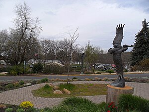
Klamath Falls is a city in and the county seat of Klamath County, Oregon, United States. The city was originally called Linkville when George Nurse founded the town in 1867. It was named after the Link River, on whose falls the city was sited. The name was changed to Klamath Falls in 1893. The population was 20,840 at the 2010 census. The city is on the southeastern shore of the Upper Klamath Lake and approximately 25 miles (40 km) north of the California–Oregon border.
U.S. Route 97 in the U.S. state of Oregon is a major north–south United States highway which runs from the California border, south of Klamath Falls, to the Washington border on the Columbia River, between Biggs Junction, Oregon and Maryhill, Washington. Other than the northernmost stretch, US 97 is known as The Dalles-California Highway. In May 2009, Oregon Senate passed a bill to rename US 97 as "World War II Veterans Historic Highway".

Oregon Route 62 is an Oregon state highway that runs between the city of Medford, and U.S. Route 97 between Chiloquin and Klamath Falls. The highway approaches Crater Lake National Park from the south, and is known as the Crater Lake Highway. While the highway is signed east-to-west, it is in reality shaped somewhat like a horseshoe; heading north-northeast from Medford, turning east as it approaches the park, and then turning south-southeast as it approaches Klamath Falls. Oregon Route 140 intersects with OR 62 in White City and Oregon Route 66. These are more direct routes between Medford and Klamath Falls. Route 62 comprises a portion of the Volcanic Legacy Scenic Byway.

Algoma is an unincorporated community on the east shore of Upper Klamath Lake, in Klamath County, Oregon, United States. It is about 8 miles (13 km) north of the city of Klamath Falls on U.S. Route 97. Algoma was named for the Algoma Lumber Company.

The Klamath Basin is the region in the U.S. states of Oregon and California drained by the Klamath River. It contains most of Klamath County and parts of Lake and Jackson counties in Oregon, and parts of Del Norte, Humboldt, Modoc, Siskiyou, and Trinity counties in California. The 15,751-square-mile (40,790 km2) drainage basin is 35% in Oregon and 65% in California. In Oregon, the watershed typically lies east of the Cascade Range, while California contains most of the river's segment that passes through the mountains. In the Oregon-far northern California segment of the river, the watershed is semi-desert at lower elevations and dry alpine in the upper elevations. In the western part of the basin, in California, however, the climate is more of temperate rainforest, and the Trinity River watershed consists of a more typical alpine climate.
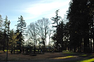
Shute Park is a municipal park in the city of Hillsboro, Oregon, United States. Acquired in 1906, the 13-acre (53,000 m2) park is the oldest park in the city. Located at southeast Tenth and Maple streets along Tualatin Valley Highway, Shute Park includes an aquatic center, a branch of the Hillsboro Public Library, and a community center. The park once had a pavilion that contained a roller skating rink, and was the center of civic activities before the opening of the Washington County Fairgrounds. Named for businessman John W. Shute, the park at one time included land on the east side of the highway that consisted mainly of a baseball field.
Interstate 5 (I-5) in the U.S. state of Oregon is a major Interstate Highway that traverses the state from north to south. It travels to the west of the Cascade Mountains, connecting Portland to Salem, Eugene, Medford, and other major cities in the Willamette Valley and across the northern Siskiyou Mountains. The highway runs 308 miles (496 km) from the California state line near Ashland to the Washington state line in northern Portland, forming the central part of Interstate 5's route between Mexico and Canada.

Geothermal power is power generated by geothermal energy. Technologies in use include dry steam power stations, flash steam power stations and binary cycle power stations. Geothermal electricity generation is currently used in 26 countries, while geothermal heating is in use in 70 countries.
Rail transportation is an important element of the transportation network in the U.S. state of Oregon. Rail transportation has existed in Oregon in some form since 1855, and the state was a pioneer in development of electric railway systems. While the automobile has displaced many uses of rail in the state, rail remains a key means of moving passengers and freight, both within the state and to points beyond its borders.

The Oregon Korean War Memorial is a war memorial located in Wilsonville, Oregon, United States. Completed in 2000, it honors the Oregon soldiers and the Korean people from the Korean War. The memorial is located within a 5.5-acre (22,000 m2) city park and features a 109-foot (33 m)-long granite wall that includes the names of those Oregonians who died or were listed as missing from the war.

Town Center Park is a small municipal park in Wilsonville, Oregon, United States. Located in the middle of Wilsonville's town center, the 5-acre (2.0 ha) park cost $4.5 million to complete. The park includes the Oregon Korean War Memorial, a visitor's center, paths, a play area, picnic tables, and an amphitheater among other features. Completed in 2005, Town Center Park is also home to Wilsonville's first interactive water feature.
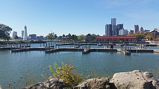
The William G. Milliken State Park and Harbor is a public recreation area located on the Detroit River just east of downtown Detroit, Michigan, on a portion of the city's International Riverfront. The state park's 31 acres (13 ha) include wetlands, paved trails, and a 52-slip harbor of refuge. A 63-foot (19 m) conical brick lighthouse tower, designed as a scaled-down replica of the Tawas Point Light, marks the harbor entrance.

The 14th Regiment Armory, also known as the Eighth Avenue Armory and the Park Slope Armory, is a historic National Guard armory building located on Eighth Avenue between 14th and 15th Streets in the South Slope neighborhood of Brooklyn, New York City, United States. The building is a brick and stone castle-like structure, and designed to be reminiscent of medieval military structures in Europe. It was built in 1891–95 and was designed in the Late Victorian style by William A. Mundell.

Southern Pacific Railroad (SP) 2579 is a heavy 2-8-0 type steam locomotives built by Baldwin Locomotive Works in 1906, a typical example of over 350 locomotives called "Consolidations". 2579 was retired from service in 1956 and is currently in display in the Veterans Memorial Park in Klamath Falls, Oregon. Last used in revenue service in November 1956, 2579 was donated to the City of Klamath Falls on September 1957.
Veterans Memorial Park may refer to:
Nuss Lake is a small private lake in Klamath Falls, Oregon, United States. It is 0.2 sq mi (0.52 km2) in size, located approximately 6.6 miles from Altamont. The lake sits between the south skirt of Stukel Mountain and Olene Gap to the north.

Moore Park is a municipal park in Klamath Falls, Oregon, United States. It is located along a section of the south end of the Upper Klamath Lake. Because almost all the fishing on the Klamath Lake requires a boat, with the exception of a few springtime bank fisheries, paved boat ramps at Moore Park are popular access points to the Lake for fishing.

Klamath was the first and only vessel larger than a launch to operate on Lower Klamath Lake, which straddled the border between the U.S. states of Oregon and California. This vessel is chiefly known for having been hauled overland by rail from Lake Ewauna to Upper Klamath Lake. It was also one of only two licensed merchant vessels ever to operate on lower Klamath Lake. During 1905 to 1909, Klamath was an essential link in a transportation line to Klamath Falls which involved rail, stage coach, and steamer travel. The late arrival of railroads to the Klamath lakes region made riverine and lake transport more important to the area.