Klis

Last updated
Klis
HR-Festung-Klis-07.jpg
Klis.png
Klis Municipality.PNG
Klis
Croatia location map.svg
Red pog.svg
Klis
Coordinates: 43°34′N16°31′E / 43.567°N 16.517°E / 43.567; 16.517
Country Flag of Croatia.svg  Croatia
Historical region Dalmatian Hinterland
County Flag of Split-Dalmatia County.svg  Split-Dalmatia
Area
[1]
   Municipality 149.1 km2 (57.6 sq mi)
  Urban
24.1 km2 (9.3 sq mi)
Population
 (2021) [2]
   Municipality 5,226
  Density35/km2 (91/sq mi)
   Urban
3,496
  Urban density150/km2 (380/sq mi)
Time zone UTC+1 (CET)
Website klis.hr
Klis seen from the Klis Fortress Klis seen from the fortress.jpg
Klis seen from the Klis Fortress

Klis (Croatian : Klis, Italian : Clissa, Turkish : Kilis) is a Croatian village and a municipality located around a mountain fortress bearing the same name.

Contents

Population

In the 2011 census the municipality of Klis had a total population of 4,801, consisting of the following settlements: [3]

Geography

It is a suburb of Split located in the region of Dalmatia, located just northeast of Solin and Split proper near the eponymous mountain pass. [4]

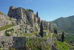
The Klis mountain pass separates the mountains Mosor and Kozjak at an altitude of 360m. It has had a major strategic value throughout history because any inland force passing through Klis would have been able to easily reach the entire region of Split and Kaštela.

Due to its geographical position Klis is also susceptible to a rather strong bura wind.

History

During the Ottoman wars in Europe an already existing Roman fortress on a nearby hill was expanded into Klis Fortress. It was the centre of a sanjak within the Province of Bosnia during Ottoman rule. Klis was also ruled by the Kingdom of Bosnia, the Venetian Republic, [5] and Austria-Hungary.

In Klis area was first mentioned name of "Uskoks" [6]

Notable objects

Transportation

The village is served by local bus from Split city centre.

See also

Related Research Articles

<span class="mw-page-title-main">Karlovac</span> City in Karlovac County, Croatia

Karlovac is a city in central Croatia. In the 2021 census, its population was 49,377.

<span class="mw-page-title-main">Senj</span> Town in Lika-Senj, Croatia

Senj is a town on the upper Adriatic coast in Croatia, in the foothills of the Mala Kapela and Velebit mountains.

<span class="mw-page-title-main">Makarska</span> City in Split-Dalmatia, Croatia

Makarska is a town on the Adriatic coastline of Croatia, about 60 km (37 mi) southeast of Split and 140 km (87 mi) northwest of Dubrovnik, in the Split-Dalmatia County.

<span class="mw-page-title-main">Skradin</span> Town in Šibenik-Knin, Croatia

Skradin is a small town in the Šibenik-Knin County of Croatia. It is located near the Krka river and at the entrance to the Krka National Park, 17 km (11 mi) from Šibenik and 100 km (62 mi) from Split. The main attraction of the park, Slapovi Krke, is a series of waterfalls, the biggest of which, Skradinski buk, was named after Skradin.

<span class="mw-page-title-main">Sinj</span> Town in Split-Dalmatia, Croatia

Sinj is a town in the continental part of Split-Dalmatia County, Croatia.

<span class="mw-page-title-main">Imotski</span> Town in Split-Dalmatia, Croatia

Imotski is a small town on the northern side of the Biokovo massif in the Dalmatian Hinterland of southern Croatia, near the border with Bosnia and Herzegovina. Imotski, like the surrounding inland Dalmatia, has a generally mild Mediterranean climate which makes it a popular tourist destination.

<span class="mw-page-title-main">Uskoks</span> Irregular soldiers in Habsburg Croatia

The Uskoks were irregular soldiers in Habsburg Croatia that inhabited areas on the eastern Adriatic coast and surrounding territories during the Ottoman wars in Europe. Bands of Uskoks fought a guerrilla war against the Ottomans, and they formed small units and rowed swift boats. Since the uskoks were checked on land and were rarely paid their annual subsidy, they resorted to acts of piracy.

<span class="mw-page-title-main">Drniš</span> Town in Dalmatian Hinterland, Croatia

Drniš is a town in the Šibenik-Knin County, Croatia. Located in the Dalmatian Hinterland, it is about halfway between Šibenik and Knin.

<span class="mw-page-title-main">Omiš</span> Town in Split-Dalmatia, Croatia

Omiš is a town and port in the Dalmatia region of Croatia, and a municipality in the Split-Dalmatia County. The town is approximately 25 kilometres south-east of Croatia's second largest city, Split, where the Cetina River meets the Adriatic Sea. Omiš municipality has a population of 14,936 and its area is 266 square kilometres (103 sq mi).

<span class="mw-page-title-main">Obrovac, Croatia</span> Town in Zadar, Croatia

Obrovac is a town located in northern Dalmatia, in the Zadar County of Croatia. The Obrovac municipality has a total population of 4,323 people. The town is located in the canyon of the river Zrmanja.

<span class="mw-page-title-main">Karlobag</span> Municipality in Lika-Senj, Croatia

Karlobag is a seaside municipality on the Adriatic coast in Croatia, located underneath the Velebit mountains overlooking the island of Pag, west of Gospić and south of Senj. The Gacka river also runs through the area.

<span class="mw-page-title-main">Trilj</span> Town in Split-Dalmatia, Croatia

Trilj is a municipality and town in inland Dalmatia, Croatia. It is located northeast of Split.

<span class="mw-page-title-main">Perušić</span> Municipality in Lika-Senj, Croatia

Perušić is municipality (općina) in Lika-Senj County, Croatia. The municipality has 2,638 inhabitants, while the settlement itself has 852. The municipality is within the mountainous Lika region of central Croatia. The Kosinj valley region sprawls alongside it.

Kaštel Novi is a town within the administrative area of Kaštela in Dalmatia, Croatia. Its name means New Castle.

<span class="mw-page-title-main">Fortress of Klis</span> Medieval fortress in Klis, Croatia

The Klis Fortress is a medieval fortress situated above a village bearing the same name, near Split, Croatia. From its origin as a small stronghold built by the ancient Illyrian tribe Dalmatae, becoming a royal castle that was the seat of many Croatian kings, to its final development as a large fortress during the Ottoman wars in Europe, Klis Fortress has guarded the frontier, being lost and re-conquered several times throughout its more-than-two-thousand-year-long history. Due to its location on a pass that separates the mountains Mosor and Kozjak, the fortress served as a major source of defense in Dalmatia, especially against the Ottoman advance, and has been a key crossroad between the Mediterranean belt and the Balkan rear.

Blinja is a village in central Croatia, in the Town of Petrinja, Sisak-Moslavina County. It is connected by the D30 highway.

<span class="mw-page-title-main">Sumartin</span> Village in Split-Dalmatia County, Croatia

Sumartin is a port village in Croatia on the island of Brač. It is the youngest village on the island of Brač and administratively belongs to Municipality of Selca. According to 2011 census, it has a population of 491. Village was founded on 11 November 1646 - the feast day of Saint Martin - by the refugees from the Dalmatian coast and Bosnia and Herzegovina who fled from the Ottomans. It is connected by the D113 highway and by ferry.

<span class="mw-page-title-main">Siege of Klis</span> Part of the Croatian–Ottoman wars and Ottoman–Habsburg wars

The siege of Klis or Battle of Klis was a siege of Klis Fortress in the Kingdom of Croatia within Habsburg monarchy. The siege of the fortress, which lasted for more than two decades, and the final battle near Klis in 1537, were fought as a part of the Ottoman–Habsburg wars between the defending Croatian–Habsburg forces under the leadership of Croatian feudal lord Petar Kružić, and the attacking Ottoman army under the leadership of the Ottoman general Murat-beg Tardić.

Islam Grčki is a village in the municipality of Benkovac, in the Zadar County, Croatia.

<span class="mw-page-title-main">Šumber</span> Village in Istria County, Croatia

Šumber is a village and ruinous castle in the eastern part of Istria County, Croatia, in the municipality of Sveta Nedelja.

References

  1. Register of spatial units of the State Geodetic Administration of the Republic of Croatia. Wikidata   Q119585703.
  2. "Population by Age and Sex, by Settlements, 2021 Census". Census of Population, Households and Dwellings in 2021. Zagreb: Croatian Bureau of Statistics. 2022.
  3. "Population by Age and Sex, by Settlements, 2011 Census: Klis". Census of Population, Households and Dwellings 2011. Zagreb: Croatian Bureau of Statistics. December 2012.
  4. The Rough Guide to Croatia by Jonathan Bousfield
  5. When Ethnicity did not Matter in the Balkans: by John Van Antwerp Fine.page 173.
  6. University Study of Pedagogy and History, The origin and military activity of the Uskoks, Hrvoje Sopta, 2017.https://repozitorij.ffos.hr/islandora/object/ffos%3A2247/datastream/PDF/view #page=3

43°34′N16°31′E / 43.567°N 16.517°E / 43.567; 16.517