
Airedale is a valley, or dale, in North Yorkshire and West Yorkshire, England. It is named after the River Aire, which flows through it. The upper valley, from Malham Cove to Airton, is known as Malhamdale, named after the village of Malham. At Airton the valley widens and becomes Airedale proper. The river flows past Skipton on to Keighley, Bingley, Shipley, and Leeds.

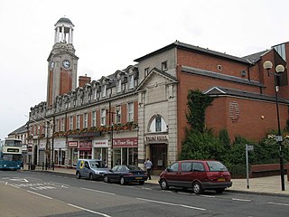
Knottingley is a town in the City of Wakefield in West Yorkshire, England on the River Aire and the old A1 road before it was bypassed as the A1(M). Historically part of the West Riding of Yorkshire, it has a population of 13,503, increasing to 13,710 for the City of Wakefield ward at the 2011 Census. It makes up the majority of the Knottingley ward represented on Wakefield Council.

Wakefield, also known as the City of Wakefield, is a local government district with city status and a metropolitan borough in West Yorkshire, England. Wakefield, the largest settlement, is the administrative centre of the district. The population of the City of Wakefield at the 2011 Census was 325,837.
Beal is a village and civil parish in North Yorkshire, England. It is situated on the River Aire, 3.5 miles (6 km) north-east of Knottingley, 8 miles (13 km) south-west of Selby, and 21 miles (34 km) south of York. The parish includes the village of Kellingley, and borders the City of Wakefield in West Yorkshire. At the 2001 census it had a population of 720, increasing to 738 at the 2011 census.

The Ferrybridge power stations were a series of three coal-fired power stations on the River Aire near Ferrybridge in West Yorkshire, England, in operation from 1927 to 2016 on a site next to the junction of the M62 and A1(M) motorways.

Kellingley Colliery, known affectionately as the 'Big K', was a deep coal mine in North Yorkshire, England, 3.6 miles (5.8 km) east of Ferrybridge power station. It was owned and operated by UK Coal.

Chiswick Town Hall stands on Heathfield Terrace, Chiswick, London, facing Turnham Green. It is a Grade II listed building.

The Old Town Hall, Richmond on Whittaker Avenue in Richmond, London is a former municipal building which from 1893 to 1965 served as the town hall for the Municipal Borough of Richmond.

Anerley Town Hall is a municipal building in Anerley Road, Anerley, London. It is a locally listed building.
Spennymoor Town Hall is a municipal building in Spennymoor, County Durham, England. The town hall is the meeting place of Spennymoor Town Council.

Farnham Town Hall is a municipal building in South Street, Farnham, Surrey, England. It provides the offices and the meeting place of Farnham Town Council.

The Church of St Botolph is an active Anglican parish church in the town of Knottingley, West Yorkshire, England. It is in the archdeaconry of York and the Diocese of Leeds. The church is named after St. Botolph and is a grade II listed building.

The Old Town Hall is a municipal structure in Scarva Street in Banbridge, County Down, Northern Ireland. The structure, which currently accommodates a Community Advice Centre on the ground floor and a room for local community groups on the first floor, is a Grade B1 listed building.
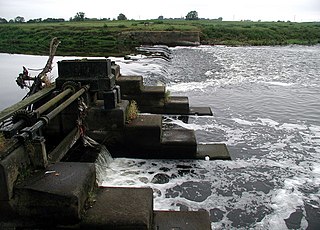
Knottingley is a town, and Ferrybridge is a village, in the Knottingley ward in the metropolitan borough of the City of Wakefield, West Yorkshire, England. They contain eight listed buildings that are recorded in the National Heritage List for England. All the listed buildings are designated at Grade II, the lowest of the three grades, which is applied to "buildings of national importance and special interest". The listed buildings consist of two churches, houses, a former toll house, two war memorials, and a building in a former power station.

The Queen's Hall, formerly Hexham Town Hall, is a municipal structure in Beaumont Street, Hexham, Northumberland, England. The structure, which was the headquarters of Hexham Urban District Council and is now an arts centre, is a Grade II listed building.

Guiseley Theatre, formerly Guiseley Town Hall, is a municipal building at The Green, Guiseley, West Yorkshire, England. The structure, which was once the headquarters of Guiseley Urban District Council, is now a theatre.

Tring Market House is a municipal building in the High Street, Tring, Hertfordshire, England. The structure, which is the meeting place of Tring Town Council, is a Grade II listed building.

Horbury Town Hall is a former municipal building in Westfield Road, Horbury, West Yorkshire, England. The structure, which is now used as business centre, is a locally listed building.

Mold Town Hall is a municipal structure in Earl Road in Mold, Wales. The town hall, which serves as the meeting place of Mold Town Council, is a Grade II listed building.

Berkhamsted Civic Centre is a municipal building in the High Street in Berkhamsted in Hertfordshire, England. The structure accommodates the offices and meeting place of Berkhamsted Town Council.

