Kollnburg

Last updated
Kollnburg
Rathaus Kollnburg-2.JPG
Town hall
DEU Kollnburg COA.svg
Location of Kollnburg within Regen district
Kollnburg in REG.svg
Germany adm location map.svg
Red pog.svg
Kollnburg
Bavaria location map.svg
Red pog.svg
Kollnburg
Coordinates: 49°3′N12°52′E / 49.050°N 12.867°E / 49.050; 12.867
Country Germany
State Bavaria
Admin. region Niederbayern
District Regen
Government
   Mayor (202026) Herbert Preuß [1] (FW)
Area
  Total59.52 km2 (22.98 sq mi)
Elevation
655 m (2,149 ft)
Population
 (2022-12-31) [2]
  Total2,802
  Density47/km2 (120/sq mi)
Time zone UTC+01:00 (CET)
  Summer (DST) UTC+02:00 (CEST)
Postal codes
94262
Dialling codes 09942
Vehicle registration REG
Website www.kollnburg.de

Kollnburg is a municipality in the district of Regen, in Bavaria, Germany. A part of the municipal area, including the parish village of the same name, is a state-approved resort.

Contents

Geography

The community is located in the Donau Forest region in the middle of the Bavarian Forest north of the 1050 m high Proeller between Viechtach (five kilometers) and Sankt Englmar (six kilometers). The two towns of Bogen and Regen are each 27 km away, while Deggendorf and Cham are each 31 km away.

History

Community Planting

The local history is closely connected to its fortress Burgruine Kollnburg  [ de ], which was first mentioned in 1153 as Chalnberch. It was still called Kalmperg in 1685, while Bernhard Grueber  [ de ] and Adalbert Müller  [ de ] called it Kohlenburg in their book Der Bavarian Forest, published in 1846. In the "Contributions to the Statistics of the Kingdom of Bavaria" the place is already referred to as Kollnburg in issue XXI from 1869.

Kollnburg belonged to the Barons von Kastner. The place was part of the Electorate of Bavaria, but formed a closed Hofmark, whose seat was Kollnburg. In the course of the administrative reforms in Bavaria, today's municipality came into being with the municipal edict  [ de ].

Incorporation

In the course of the regional reform in Bavaria  [ de ], the municipality of Rechertsried was incorporated on October 1, 1971, and the municipalities of Allersdorf and Kirchaitnach on May 1, 1978, incorporated into the municipality of Kollnburg.

Population Development

Between 1988 and 2018, the population stagnated or fell minimally from 2800 to 2795 by 5 inhabitants or 0.2%.

Politics

Municipal Council

Since the municipal elections in Bavaria 2014  [ de ], the municipal council has been composed as follows: [3]

Mayor

Herbert Preuß (FW) has been the first mayor since May 1, 2020. In the municipal elections in Bavaria 2020  [ de ], he won the run-off election on March 29, 2020, with 55.1 percent against the previous incumbent Josefa Schmid, who has been the first mayor of Kollnburg since 2008.

Coat of Arms

white DEU Kollnburg COA.svg
white

The municipal coat of arms of Kollnburg combines elements from the family coats of arms of noble families that were important for the history of the municipal area. The white and blue diamonds are reminiscent of both the Kollnburg (Kallenberger, Chalmberger), the first proven family from the 12th to the 14th century in Kollnburg, as well as the Nußberger, who followed the Kollnburg family in 1363 and possessed the castle up to their defeat in the Böckler War of 1468/69. The Kollnburgers and the Nußbergers originally belonged to the Ministerialis of the Counts of Bogen, who died out in 1242, and therefore have their diamonds in their coat of arms. The formal structure of the coat of arms is based on the fact that the Kollnburgers showed diamonds in a split shield while the Nußbergers arranged them in line. The diamonds were passed on to the Wittelsbach family with the Bogen inheritance in 1242 and later became the Bavarian state coat of arms. The crenellation at the top symbolizes the castle Burgruine Kollnburg  [ de ], which was probably built in the 11th century as the ministerial seat of the Counts of Bogen. This coat of arms has been used since 1983.

Architectural and archaeological monuments

Statistics

In 1998, according to official statistics, 10 employees in agriculture and forestry, 136 in manufacturing and 17 in trade and transport had an insurable employment. In other sectors of the economy, 137 people had an insurable employment. There were a total of 895 employees in insurable employment. There were no manufacturing companies, and 6 companies in main construction trades. In addition, in 1999 there were 181 farms with an agricultural area of 2735 ha, of which 2178 ha were permanent grasslands.

Economy and infrastructure

Tourism

The districts of Kollnburg, Bach, Baierweg, Gnad, Hochstrass, Höfen, Hornhof, Kagermühle, Karglhof, Marktbuchen, Oed, Ogleinsmais, Reichsdorf, Reisach, Sattel, Schreinermühle, Steffelhof, Tafertshof, Unterdornach, Waldhof, Weggütl, Wieshof, and Windsprach are state-recognized as resorts.

Education

There are the following institutions (status: 1999):

Personalities

Related Research Articles

Cham is a Landkreis (district) in Bavaria, Germany. It is bounded by the districts of Regen, Straubing-Bogen, Regensburg and Schwandorf and by the Czech Plzeň Region.

Regen is a Landkreis (district) in Bavaria, Germany. It is bounded by the districts of Freyung-Grafenau, Deggendorf, Straubing-Bogen and Cham, and by the Czech Republic.

Regensburg is a Landkreis (district) in Bavaria, Germany. It is bounded by the districts of Schwandorf, Cham, Straubing-Bogen, Kelheim and Neumarkt. The city of Regensburg is enclosed by it, but is not part of the district; nonetheless it is its administrative seat.

Straubing-Bogen is a Landkreis (district) in the eastern part of Bavaria, Germany. Neighboring districts are Cham, Regen, Deggendorf, Dingolfing-Landau, Landshut and Regensburg. The independent town of Straubing is surrounded by the district. The seat of the government of the district (Landratsamt) is located in Straubing.

<span class="mw-page-title-main">Zwiesel</span> Town in Bavaria, Germany

Zwiesel is a town in the lower-Bavarian district of Regen, and since 1972 is a Luftkurort with particularly good air. The name of the town was derived from the Bavarian word stem "zwisl" which refers to the form of a fork. The fork of the rivers Großer Regen and Kleiner Regen and the land that lies between these two rivers were called Zwiesel.

<span class="mw-page-title-main">Bogen, Germany</span> Town in Bavaria, Germany

Bogen is a town in the district of Straubing-Bogen in Bavaria, Germany. It has a population of 10,105. Bogen is located between the southern slopes of the Bavarian Forest and the River Danube. The town lies at the foot of the Bogenberg, a hill immediately on the Danube. The pilgrimage church of the Assumption of the Virgin Mary on the Bogenberg is the destination of one of the oldest pilgrimages for Saint Mary in Bavaria.

<span class="mw-page-title-main">Mering</span> Municipality in Bavaria, Germany

Mering is a municipality in the district Aichach-Friedberg, in Bavaria, Germany. It is located on the river Paar.

<span class="mw-page-title-main">Kleinkahl</span> Municipality in Bavaria, Germany

Kleinkahl is a community in the Aschaffenburg district in the Regierungsbezirk of Lower Franconia (Unterfranken) in Bavaria, Germany, and a member of the Verwaltungsgemeinschaft of Schöllkrippen. Kleinkahl has around 1,800 inhabitants.

<span class="mw-page-title-main">Oberding</span> Municipality in Bavaria, Germany

Oberding is a municipality in the district of Erding in Upper Bavaria in Germany, and member of the same administrative community. Almost half of the area of Munich Airport, including both terminals, falls within the municipal bounds.

<span class="mw-page-title-main">Trogen, Bavaria</span> Municipality in Bavaria, Germany

Trogen is a municipality in Upper Franconia in the district of Hof in Bavaria in Germany.

<span class="mw-page-title-main">Burgsinn</span> Municipality in Bavaria, Germany

Burgsinn is a market community in the Main-Spessart district in the Regierungsbezirk of Lower Franconia (Unterfranken) in Bavaria, Germany and the seat of the Verwaltungsgemeinschaft of Burgsinn. It has a population of around 2,500.

<span class="mw-page-title-main">Eichenbühl</span> Municipality in Bavaria, Germany

Eichenbühl is a community in the Miltenberg district in the Regierungsbezirk of Lower Franconia (Unterfranken) in Bavaria, Germany.

<span class="mw-page-title-main">Eschau</span> Municipality in Bavaria, Germany

Eschau is a market community in the Miltenberg district in the Regierungsbezirk of Lower Franconia (Unterfranken) in Bavaria, Germany. It has a population of around 3,800.

<span class="mw-page-title-main">Neuburg am Inn</span> Municipality in Bavaria, Germany

Neuburg am Inn is a municipality in the district of Passau in Bavaria in Germany.

<span class="mw-page-title-main">Unsleben</span> Municipality in Bavaria, Germany

Unsleben is a municipality in the district of Rhön-Grabfeld in Bavaria in Germany.

<span class="mw-page-title-main">Mallersdorf-Pfaffenberg</span> Municipality in Bavaria, Germany

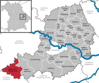
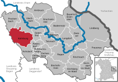
Mallersdorf-Pfaffenberg is a municipality in the district of Straubing-Bogen in Bavaria, Germany and has around 7000 inhabitants.

<span class="mw-page-title-main">Mitterfels</span> Municipality in Bavaria, Germany

Mitterfels is a municipality in the district of Straubing-Bogen in Bavaria, Germany. It is the head of the Verwaltungsgemeinschaft Mitterfels.

<span class="mw-page-title-main">Haselbach, Bavaria</span> Municipality in Bavaria, Germany

Haselbach is a municipality in the district of Straubing-Bogen in Bavaria, Germany.

<span class="mw-page-title-main">Neukirchen, Lower Bavaria</span> Municipality in Bavaria, Germany

Neukirchen is a municipality in the district of Straubing-Bogen in Bavaria, Germany. It is located in the Donau-Wald region in the Bavarian Forest.

<span class="mw-page-title-main">Weißenstein Castle (Lower Bavaria)</span> Castle in Lower Bavaria, Germany

Weißenstein Castle is a ruined rock castle at a height of 758 metres on a quartz ridge, the Pfahl ("Burgberg") in the municipality of Weißenstein in the borough of Regen in the county of Regen in Bavaria.

References