Lake Chad is an endorheic freshwater lake located at the junction of four countries: Nigeria, Niger, Chad, and Cameroon in western and central Africa respectively, with a catchment area of 1×10^6 km2 (390,000 sq mi). It is an important wetland ecosystem in West-Central Africa. The lakeside is rich in reeds and swamps, and the plain along the lake is fertile, making it an important irrigated agricultural area. The lake is rich in aquatic resources and is one of the important freshwater fish producing areas in Africa.
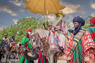
The Kanuri people are an African ethnic group living largely in the lands of the former Kanem and Bornu Empires in Niger, Nigeria, Chad, and Cameroon. As well as a diaspora community residing in Sudan. Those generally termed Kanuri include several subgroups and dialect groups, some of whom identify as distinct from the Kanuri. Most trace their origins to ruling lineages of the medieval Kanem-Bornu Empire, and its client states or provinces. In contrast to the neighboring Toubou or Zaghawa pastoralists, Kanuri groups have traditionally been sedentary, engaging in farming, fishing the Chad Basin, trade, and salt processing.

Benue River, previously known as the Chadda River or Tchadda, is the major tributary of the Niger River. Almost its entire length of approximately 1,400 kilometres (870 mi) is navigable during the summer months. The size of its catchment basin is 319,000 km2 (123,000 sq mi). As a result, it is an important transportation route in the regions through which it flows. The name Benue comes from Binuwe meaning 'Mother of Waters’ in the Batta language.
Ngazargamu, Birni Ngazargamu, Birnin Gazargamu, Gazargamo or N'gazargamu, was the capital of the Bornu Empire from ca. 1460 to 1809. Situated 150 km (93 mi) west of Lake Chad in the Yobe State of modern Nigeria, the remains of the former capital city are still visible. The surrounding wall is 6.6 km (4.1 mi) long and in parts it is still up to 5 m (16 ft) high.

Borno State is a state in the North-East geopolitical zone of Nigeria, bordered by Yobe to the west for about 421 km, Gombe to the southwest for 93 km, and Adamawa to the south while its eastern border forms part of the national border with Cameroon for about 426 km, its northern border forms part of the national border with Niger, for about 223 km mostly across the Komadougou-Yobe River, and its northeastern border forms all of the national border with Chad for 85 km, being the only Nigerian state to border three foreign countries. It takes its name from the historic emirate of Borno, with the emirate's old capital of Maiduguri serving as the capital city of Borno State. The state was formed in 1976 when the former North-Eastern State was broken up. It originally included the area that is now Yobe State, which became a distinct state in 1991.
Jigawa State is one of the 36 states of Nigeria, located in the northern region of the country. Created on 27 August 1991, under the General Ibrahim Babangida administration who announced the creation of nine additional states in the country bringing the total number of states then to thirty. The announcement was given a legal backing through the; State Creation and Transitional Provisions Decree No. 37 of 1991. Jigawa State was a part of Kano State and was located in the northeastern-most region of Kano State, and it forms part of Nigeria's national border with the Republic of Niger. The state capital and largest city is Dutse. Jigawa state has 27 local governments

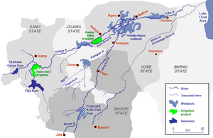
The Hadejia-Nguru wetlands in Yobe State in northern Nigeria, which include Nguru Lake, are ecologically and economically important. They are threatened by reduced rainfall in recent years, a growing population and upstream dam construction.
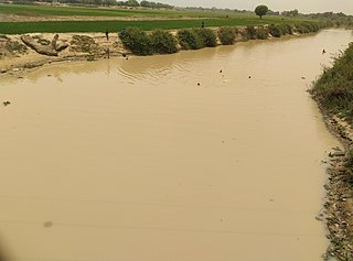
The Hadejia River is a river in Northern Nigeria and is a tributary of the Yobe River. Among the cities and towns that lie on or near its banks are Hadejia and Nguru. Damming of the river for the purposes of irrigation has led to a decrease in the amount of water in the Hadejia-Nguru wetlands, which the river forms along with Nguru Lake.
The Yobe River, also known as the Komadougou Yobe also spelt Komadugu Yobe River or the Komadougou-Yobe, is a river in West Africa that flows into Lake Chad through Nigeria and Niger. Its tributaries include the Hadejia River, the Jama'are River, and the Komadugu Gana River. The river forms a small part of the international border between Niger and Nigeriawith 95 miles and flows a total of 200 miles

The Dufuna canoe is a dugout canoe discovered in 1987 by a Fulani cattle herdsman a few kilometers from the village of Dufuna in the Fune Local Government Area, not far from the Komadugu Gana River, in Yobe State, Nigeria. Radiocarbon dating of a sample of charcoal found near the site dates the canoe at 8,500 to 8,000 years old, linking the site to Lake Chad. The canoe is 8.4 metres (28 ft) long and is 0.5 metres tall at it largest point. It is currently located in Damaturu, Nigeria.
The Kafin Zaki Dam is a controversial project to build a reservoir on the Jama'are River in Bauchi State in the Northeast of Nigeria.

The Jama'are River, also known as the Bunga River in its upper reaches, starts in the highlands near Jos, Plateau State, Nigeria and flows northeast through Bauchi State and Yobe State before joining the Hadejia River to form the Yobe River. There has recently been controversy over a plan to build the Kafin Zaki Dam on this river, with concerns over the effect on seasonal flooding and the water table.
Marte is a Local Government Area of Borno State, Nigeria, on the western coast of Lake Chad. Its headquarters are in the town of Marte

Fune is a Local Government Area (LGA) in Yobe State, Nigeria. Its headquarters are in the town of Damagum in the southwest of the area on the A3 highway at 11°40′39″N11°20′04″E. It has an area of 4,948 km2 and a population of 300,760 at the 2006 census. The postal code of the area is 622.
The Chad Basin National Park is a national park in northeastern Nigeria, in the Chad Basin, with a total area of about 2,258 km2. The park is fragmented, with three sectors. The Chingurmi-Duguma sector is in Borno State, in a Sudanian Savanna ecological zone. The Bade-Nguru Wetlands and Bulatura sectors are in Yobe State in the Sahel ecological zone.
Damasak is the head town of the Mobbar Local Government Area, in the northeastern Nigerian state of Borno. It is located near the confluence of the Yobe River and Komadugu Gana River, adjoining the border with Niger.
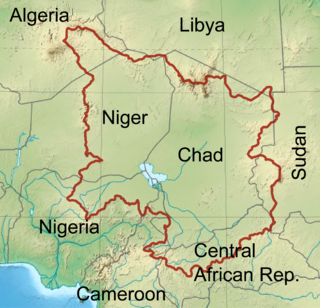
The Chad Basin is the largest endorheic basin in Africa, centered approximately on Lake Chad. It has no outlet to the sea and contains large areas of semi-arid desert and savanna. The drainage basin is approximately coterminous with the sedimentary basin of the same name, but extends further to the northeast and east.
Timeline of the Boko Haram insurgency is the chronology of the Boko Haram insurgency, an ongoing armed conflict between Nigerian Islamist group Boko Haram and the Nigerian government. Boko Haram have carried out many attacks against the military, police and civilians since 2009, mostly in Nigeria. The low-intensity conflict is centred on Borno State. It peaked in the mid 2010s, when Boko Haram extended their insurgency into Cameroon, Chad and Niger.

The pre-history of Northern Nigeria spans the period covering from the early history of the planet to the time of written historical records. There has been very little investigation into the History of Northern Nigeria before the rise of human civilisation.