The Sea of Okhotsk is a marginal sea of the western Pacific Ocean. It is located between Russia's Kamchatka Peninsula on the east, the Kuril Islands on the southeast, Japan's island of Hokkaido on the south, the island of Sakhalin along the west, and a stretch of eastern Siberian coast along the west and north. The northeast corner is the Shelikhov Gulf. The sea is named after the Okhota river, which is in turn named after the Even word окат meaning "river".

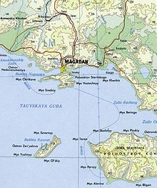
Magadan is a port town and the administrative center of Magadan Oblast, Russia, located on the Sea of Okhotsk in Nagayev Bay and serving as a gateway to the Kolyma region.
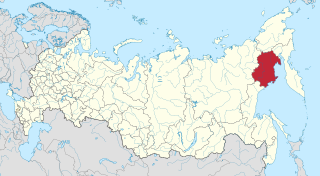
Magadan Oblast is a federal subject of Russia. It is geographically located in the Far East region of the country, and is administratively part of the Far Eastern Federal District. Magadan Oblast has a population of 136,085, making it the least populated oblast and the third-least populated federal subject in Russia.

The Kolyma is a river in northeastern Siberia, whose basin covers parts of the Sakha Republic, Chukotka Autonomous Okrug, and Magadan Oblast of Russia.

The Taymyr Peninsula is a peninsula in the Far North of Russia, in the Siberian Federal District, that forms the northernmost part of the mainland of Eurasia. Administratively it is part of the Krasnoyarsk Krai Federal subject of Russia.

The KamchatkaPeninsula is a 1,250-kilometre-long (777 mi) peninsula in the Russian Far East, with an area of about 270,000 km2 (104,248 sq mi). The Pacific Ocean and the Sea of Okhotsk make up the peninsula's eastern and western coastlines, respectively. Immediately offshore along the Pacific coast of the peninsula runs the 10,500-metre-deep (34,449 ft) Kuril–Kamchatka Trench.

Mikhail Vasilyevich Stadukhin was a Russian explorer of far northeast Siberia, one of the first to reach the Kolyma, Anadyr, Penzhina and Gizhiga Rivers and the northern Sea of Okhotsk. He was a Pomor, probably born in the village of Pinega, and the nephew of a Moscow merchant. By 1633 he was on the Lena River.

The Gyda Peninsula is a geographical feature of the Siberian coast in the Kara Sea. It takes its name from the river Gyda, that flows on the peninsula. It is roughly 400 km long and 360 km wide. This wide peninsula lies between the estuaries of the Ob and Yenisei Rivers. The southwestern corner of the peninsula is limited by the Taz Estuary, and across the river lies the Yamal Peninsula. The climate in the whole area is arctic and harsh.

Zavyalov Island, formerly Ola Island, is a relatively large island in the Sea of Okhotsk, northwestern Pacific. It is located on the eastern side of Taui Bay, 20 km (12 mi) west of Cape Taran, Koni Peninsula, about 50 km (31 mi) south of the city of Magadan.

Taui Bay is a body of water in the Sea of Okhotsk off the coast of the Magadan Oblast in Russia. The bay opens to the south.
Chetyre Paltsa is a small island in the northern shores of Gizhigin Bay, Sea of Okhotsk. It is located 7 km west of the coast of the Varkhalamsky Peninsula.
The Three Brothers is a group of steep white islets in the Sea of Okhotsk, about 650 m off the Eastern Cape, just outside Veselaya Bay, about 13 km from the town of Magadan in the Kamchatka peninsula, Russia. It is a local tourist landmark and a favorite target for photographers.

Umara Island is an island in the Sea of Okhotsk on the south side of Odyan Bay.

The Taui, also known as Kava part of its course, is a river in Khabarovsk Krai and Magadan Oblast, Russian Far East. It has a drainage basin of 25,900 square kilometres (10,000 sq mi).

Magadan Nature Reserve is a Russian zapovednik located in four different sectors across the Magadan region of the Russian Far East, including the northern shore of the Sea of Okhotsk. All sites are far away from each other, have different climates, topography, flora and fauna, and no settlements or transportation routes. On the streams of the territory are some of the largest undisturbed spawning sites of the chum and coho salmon. One area, the Yam Islands, is home to colonies of sea birds, with a total of up to 6 million individuals. These include Auklets-crumbs, guillemot, spectacled guillemots, lund, and the horned puffin. The reserve is situated in the Olsky District of Magadan Oblast. Recently, the reserve has experimented with very limited cruise ship visits to one of the islands, and plans are being studied for ways to increase educational eco-tourism in the highly inaccessible area.
Cape Alevina is a cape on the northern side of the Sea of Okhotsk. It is on the Koni Peninsula and is the southernmost point of Magadan Oblast, Russia.
Odyan Bay is a small bay on the north coast of the Sea of Okhotsk. It is in the eastern corner of Taui Bay and washes the Koni Peninsula on the south. The bay is entered between Cape Beringa to the northeast and Cape Skalisty to the southwest. It is 19.3 km wide. The high entrance points of the bay merge to form a low, sandy shore at its head. Sea ice remains in the bay longer than in other parts of Taui Bay. It is sheltered from all but west winds. Umara Island lies just off its south shore.
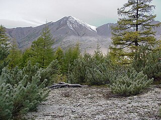
The Kolyma Mountains or Kolyma Upland, is a system of mountain ranges in northeastern Siberia, lying mostly within the Magadan Oblast, along the shores of the Sea of Okhotsk in the Kolyma region. It constitutes the watershed between the basins of Kolyma River and of the Sea of Okhotsk / Pacific Ocean.

Svyatoy Nos is a large peninsula on the eastern edge of Lake Baikal, Eastern Siberia, in the Barguzinsky District of the Republic of Buryatia. It is part of the Zabaykalsky (Trans-Baikal) National Park.
The Ola is a river in Magadan Oblast, Russian Far East. It is 166 kilometres (103 mi) long, with a drainage basin of 8,570 square kilometres (3,310 sq mi).