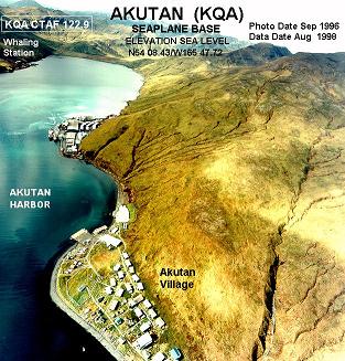
Akutan is a city on Akutan Island in the Aleutians East Borough of the Aleutian Islands in Alaska, United States. The population was 1,589 at the 2020 census, up from 1,027 in 2010, making it the 4th fastest-growing city of the decade in Alaska. Akutan Harbor is adjacent.
The Fox Islands are a group of islands in the eastern Aleutian Islands of the U.S. state of Alaska. The Fox Islands are the closest to mainland North America in the Aleutian chain, and just east of Samalga Pass and the Islands of Four Mountains group.
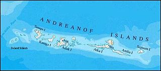
The Delarof Islands are a group of small islands at the extreme western end of the Andreanof Islands group in the central Aleutian Islands, Alaska. The Delarofs consist of 11 named islands: Amatignak, Gareloi, Ilak, Kavalga (Qavalĝa), Ogliuga (Aglaga), Skagul (Sxaĝulax̂), the Tag (Tagachaluĝis), Tanadak (Tanaadax̂), Ugidak (Qagan-tanax̂), Ulak, and Unalga (Unalĝa).
Aiktak Island is one of the Krenitzin Islands, a subgroup of the Fox Islands in the eastern Aleutian Islands in the U.S. state of Alaska. It is 1.3 miles (2.1 km) long and is located 38 miles (61 km) east of Akutan Island. Aiktak is an Aleut name transcribed by Captain Tebenkov in 1852 as "Ostrov Aikhtak." R. H. Geoghegan suggested that the name is derived from the Aleut "aikhag", meaning "travel or going on a voyage." It is also known as Ashmiak.
Avatanak Island is the second-largest of the Krenitzin Islands, a subgroup of the Fox Islands in the eastern Aleutian Islands in the U.S. state of Alaska. It lies southeast of Akun Island, across the Avatanak Strait. Within the Krenitzin Islands, it lies between Rootok Island (Aayux̂tax̂) to the west, and Tigalda Island to the east.
Derbin Island is located in the Krenitzin Islands, a subgroup of the Fox Islands in the eastern Aleutian Islands, Alaska, United States. Derbin is a small island and is situated near the southwestern shore of Tigalda Island. It is measuring 840 metres (0.52 mi) long and 204 metres (0.127 mi) wide. It was named in 1935 by the United States Coast and Geodetic Survey because of its proximity to Derbin Strait, the channel between Avatanak and Tigalda islands. Derbin Strait, in turn, is derived from "Derbenskoy," the Russian name published by Father Veniaminov (1840).
Tigalda Island is one of the Krenitzin Islands, a subgroup of the Fox Islands in the eastern Aleutian Islands, Alaska. Tigalda is located about 19 miles (31 km) east of Akutan Island, is 12 miles (19 km) long and has an area of about 35 square miles (91 km2). Tigalda is an Aleut name published by Captain Lutke (1836). It was called "Kagalga" by Captain Lt. Krenitzin and Lt. Levashev (1768). Tigalda Bay is situated on the north side of Tigalda. Father Veniaminov (1840) reported the existence of an Aleut village, which he called "Tigaldinskoe", of 91 people in 1833.
Poa Island is an islet located about 0.99 miles (1.59 km) off the south coast of Akun Island in the Fox Islands group of the eastern Aleutian Islands, Alaska. The island is 0.62 miles (1.00 km) long and reaches a maximum elevation of about 200 feet (61 m) above sea level. It was named for a genus of grasses in 1888 by the U.S. Bureau of Fisheries. Captain Tebenkov (1852) called it "Ostrov Tumannyi," meaning "foggy island."
Pustoi Island is an island in the Fox Islands group of the eastern Aleutian Islands, Alaska. It is 0.3 miles across and is located in Umnak Pass 2 mi north of Ship Rock off the northeast coast of Umnak Island. The name is derived from the Russian "Ostrov Pustoy," meaning "desert island," a name given to it by navigator Peter Kuzmich Krenitzin and published by Captain Tebenkov in 1852.
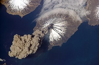
Chuginadak Island is the largest island in the Islands of Four Mountains subgroup of the Aleutian archipelago. Chuginadak is an Aleutian name published by Captain Tebenkov in an 1852 map. According to Knut Bergsland's Aleut Dictionary, the Aleutian word "chugida-lix" means "to fry, to make sizzle." The Western half of the island is called Chuginadax in Aleut, meaning 'simmering'.
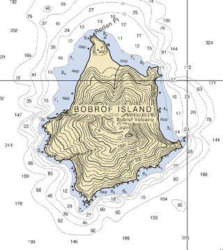
Bobrof Island is one of the Andreanof Islands subgroup of the Aleutian Islands in southwestern Alaska, United States. Bobrof Island is a small, uninhabited island about 9 miles (14 km) north and west of Kanaga Island, and 7 miles (11 km) northeast of Cape Sudak on Tanaga Island. Bobrof Island is 2.6 miles (4.2 km) long and 1.8 miles (2.9 km) wide with an area of 3 square miles (7.8 km2), and consists primarily of the 2,421-foot (738 m) high Bobrof Volcano. The volcanic crater, or cone, has been heavily dissected. Underwater deposits adjacent to the island's northeast flank suggest an immense debris-avalanche has taken place.

Akun Island is one of the Fox Islands subgroup of the Aleutian Islands in the Aleutians East Borough of southwestern Alaska.
Egg Island is a small island in the Fox Islands subgroup of the Aleutian Islands in the U.S. state of Alaska. It lies off the eastern end of Unalaska Island and just off the northeastern tip of Sedanka Island. It is the easternmost island in the Aleutians West Census Area of Alaska. The island has a land area of 311.12 acres (1.2591 km2) and is uninhabited.

The Walrus Islands are a group of craggy coastal islands in the Bering Sea, close to the northern shores of Bristol Bay, Alaska at the entrance to Togiak Bay. They are located 18 km to the east of Hagemeister Island, and are protected as the Walrus Islands State Game Sanctuary by the state. A part of the island group is also of archaeological importance, with numerous deeply stratified sites covering 6,000 years of human use. For this reason, Crooked Island, Summit Island and Round Island were designated the Walrus Islands Archeological District, a National Historic Landmark District comprising 14 historical sites, in December 2016.

Cape Lutke is a headland on Unimak Island, the largest island in the Aleutian Islands chain of the U.S. state of Alaska. It is located on the southern central coast of the island.
Pyotr Kuzmich Krenitsyn, spelt "Krenitzin" in the United States, was a Russian explorer and Captain/Lieutenant of the Imperial Russian Navy. Following Vitus Bering's 1741 tragic venture he was the first to conduct an expedition to Alaska and the Aleutians. Krenitsyn was sent, together with Mikhail Levashev, by Russian Empress Catherine II to explore the northern parts of the Pacific Ocean and particularly the area around the Bering strait in four ships. Krenitsyn was the commander of the ship St. Catherine and Levashev commanded the ship St. Paul.
Rootok Island (also called Aektok, Aiaktak, Ouektock, Aiaiepta, Veniaminof, or Goloi is the smallest member of the Krenitzin Islands, a subgroup of the Fox Islands in the eastern Aleutian Islands in Alaska, United States. The island's common spelling of Rooktok appears to have arisen from Aektok. Deviations in compass readings of up to 3 degrees from normal have been observed off the island's north-western side. The island was set aside to house a lighthouse on January 4, 1901; though no navigation aids were ever constructed. The island is uninhabited and it is 6.3 kilometres long and 6.2 kilometres wide.
Akutan Island is an inhabited island in the Fox Islands group of the eastern Aleutian Islands in the Aleutians East Borough of Alaska.
Kaligagan Island is an island located in the Krenitzin Islands of Alaska.
