Tilak Nagar is a suburban area and commercial hub in the district of West Delhi, Delhi, India.
Ramakrishna Puram popularly known as R.K. Puram, is a residential colony in Delhi. Named after the saint Sri Ramakrishna, it houses many high-profile corporate houses.

Kamla Nagar is a residential and commercial neighbourhood in North Delhi, India. It is one of Delhi's major shopping centres.

Delhi is an ancient centre of Jainism, home to over 165 Jain temples. Delhi has a large population of Jains spread all over the city. It has had continued presence of a Jain community throughout its history, and it is still a major Jain centre.

Shivpuri District is a district of Madhya Pradesh state of India. The town of Shivpuri is the district headquarters. National Highway 3 (NH-3) runs through the district.
Vijaynagar or Vijaynagar is a town and a municipality in Sri Ganganagar district in the Indian state of Rajasthan.

ShahdaraDistrict is an administrative and revenue district of Delhi, India, situated near the banks of Yamuna river. The district headquarters is Nand Nagri. It is one of the oldest inhabited areas of Delhi and integral to what is known as Purani Dilli. Shahdara district was formed in 2012 and has a collectorate office at Nand Nagri, Delhi. Delhi Metro started its operation in 2002 from Shahdara to Tis Hazari on the Red Line.

North East Delhi is one of the eleven administrative district of Delhi, India. The district was established in 1997. North East Delhi borders the Yamuna River on the west, Ghaziabad District to the north and east, East Delhi to the south, and North Delhi to the west across the Yamuna. Karawal Nagar, Seelampur and Yamuna Vihar are 3 sub-divisions of this district.

East Delhi is an administrative district of Delhi in India. It is bounded by the Yamuna River on the west, North East Delhi to the north, Ghaziabad District of Uttar Pradesh state to the east, and Gautam Buddha Nagar District of Uttar Pradesh to the south. Administratively, the district is divided into three subdivisions: Gandhi Nagar, Preet Vihar, and Mayur Vihar.
The Civil Lines is a residential area and one of the 3 subdivisions of the Central Delhi district of Delhi in India. It is one of the 12 zones under the Municipal Corporation of Delhi. It was the hub of European-style hotels in the city until New Delhi came into being in 1911. The official residence of the Lieutenant Governor of Delhi is also located at Raj Niwas Marg, Civil Lines.
Ashok Nagar is a neighborhood in the city of Delhi. It constitutes a part of the Tilak Nagar assembly constituency as well as the West Delhi parliamentary constituency. The area was known as Tihar Village 2 before being renamed as such. It is an authorized neighborhood today, and the government of Delhi plays a role in its development.

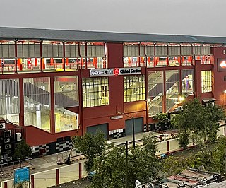
The Dilshad Garden Metro Station is a station of the Red Line of the Delhi Metro.

Anand Vihar is an interchange metro station located on the Blue Line and the Pink Line of Delhi Metro. The station is located in the Anand Vihar locality near the interstate border between Delhi and Uttar Pradesh and is a major connectivity hub of East Delhi. It is connected to the Anand Vihar ISBT and Anand Vihar Railway Terminal.

Sri Vijaynagar Tehsil is the one of nine tehsils of Sri Ganganagar district of Rajasthan, India. It is located in the southern part of District Sri Ganganagar. It is bordered by Anoopgarh tehsil in the west, by Raisinghnagar tehsil in the north, Suratgarh tehsil in the east, and Bikaner district in the south.
Narela and sub-city is a tehsil, located in the North Delhi district of Delhi, and forms the border of Delhi with Haryana. Situated just off the Grand Trunk Road, its location made it an important market town for the surrounding areas, during the 19th century, which it still retains. It was developed as the third mega sub-city project of Delhi Development Authority (DDA) in the urban extension project of Delhi, after Rohini sub-city and Dwarka sub-city. It covers an area of 9866 hectares. The 'Narela Industrial Area' started developing in the early 1980s and is today one of the important such complexes in Delhi.

Shivpuri is a neighbourhood in Patna, capital of Bihar, India.
West Patel Nagar is a place in Central Delhi. It covers the Western Part of the Patel Nagar Area. In the past West Patel Nagar was counted in Central Delhi but due continues City expansion West Patel Nagar and its Sub division colonies like New Ranjit Nagar or Baljeet Nagar come under West Delhi. However, among the 3 divisions of Municipal Corporation Of Delhi(MCD), North, South and East, West Patel Nagar falls under MCD-North
South Patel Nagar is a place in Central Delhi. It covers the Southern Part of the Patel Nagar Area. In the past South Patel Nagar was counted in Central Delhi but due to the continued city expansion, South Patel Nagar and its subdivision colonies like New Ranjit Nagar now come under West Delhi. However, among the three divisions of Municipal Corporation Of Delhi(MCD), North, South and East, South Patel Nagar falls under MCD-North.
Vijay Nagar is a major residential, industrial and commercial area in Ghaziabad, Uttar Pradesh, India. It was developed with assistance of the Ghaziabad Development Authority. The suburb is located at the junction of Noida, Greater Noida, Crossings Republik, Pratap Vihar and Indirapuram. Vijay Nagar is known for its educational institutes, industrial areas, the Ghaziabad Junction Railway Station, the Meerut Expressway, NH-24 and the Vishwakarma Road. The area has witnessed rampant growth in infrastructure and civic development. Vijay Nagar is closely linked with the adjoining Pratap Vihar area having a residential area, upcoming real estate projects and the Santosh Medical & Dental College, a part of Santosh University.The adjoining Bhur Bharat Nagar is close to Ghaziabad Railway Station, the nearest railway station that serves this area.


