You can help expand this article with text translated from the corresponding article in German. (January 2011)Click [show] for important translation instructions.
View a machine-translated version of the German article.
Machine translation, like DeepL or Google Translate, is a useful starting point for translations, but translators must revise errors as necessary and confirm that the translation is accurate, rather than simply copy-pasting machine-translated text into the English Wikipedia.
Do not translate text that appears unreliable or low-quality. If possible, verify the text with references provided in the foreign-language article.
You must provide copyright attribution in the edit summary accompanying your translation by providing an interlanguage link to the source of your translation. A model attribution edit summary is Content in this edit is translated from the existing German Wikipedia article at [[:de:Krompachy]]; see its history for attribution.
You may also add the template {{Translated|de|Krompachy}} to the talk page.
You can help expand this article with text translated from the corresponding article in Hungarian. (January 2011)Click [show] for important translation instructions.
View a machine-translated version of the Hungarian article.
Machine translation, like DeepL or Google Translate, is a useful starting point for translations, but translators must revise errors as necessary and confirm that the translation is accurate, rather than simply copy-pasting machine-translated text into the English Wikipedia.
Do not translate text that appears unreliable or low-quality. If possible, verify the text with references provided in the foreign-language article.
You must provide copyright attribution in the edit summary accompanying your translation by providing an interlanguage link to the source of your translation. A model attribution edit summary is Content in this edit is translated from the existing Hungarian Wikipedia article at [[:hu:Korompa]]; see its history for attribution.
You may also add the template {{Translated|hu|Korompa}} to the talk page.
Krompachy (German: Krombach, Hungarian: Korompa) is a town in Slovakia, with a rich mining and metallurgical history, well-known both in Slovakia and in its close neighboring countries for its Plejsy ski center.
The town was first mentioned in 1282 in a charter by King Ladislaus IV as belonging to the domain of Spiš Castle. The town's name derives from German (Krumm Bach - crooked stream), as the town was settled by German colonists.
From then onwards, it was a centre of mining and metallurgy until the end of the 20th century, particularly focussed on the iron and copper industries. At the start of the 20th century, the Krompachy Ironworks (Krompašská železiareň) had around 3,500 employees and was the biggest ironworks of its time in the Kingdom of Hungary. The Ironworks closed after World War I.
In 1921, there was a bloody uprising, known as the Krompachy Uprising (Slovak: Krompašská vzbura) in the town.
Since 1991, following the industrial decline and as a result of large-scale investment, Plejsy became an internationally visited alpine ski centre and became known as a holiday destination.
Tourism
As well as the skiing centre at Plejsy, Krompachy is known for its scenery of hills, valleys and fields. This, together with a number of local natural and cultural sites, has made the town a year-round tourist destination.
Sites
Roman Catholic church of Evangelic Saint John, built in the classical style from 1774
17th-century baroque curia reconstructed into a private hotel
The administrative building of the former ironworks
Eastern Slovakia's first water plant
Geography
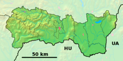
The municipality lies at an altitude of 375 metres (1,230ft)[2] and covers an area of 22.88km2 (8.83sqmi) (2024).[4] It is situated in the central Spiš area in the valley of the Hornád River. The town lies on the meeting point of three mountain ranges; the Levoča Hills (Levočské vrchy) and Branisko Massif (the highest point is Slubica 1,129 metres (3,704ft)above sea level) are to the north and the Volovec Mountains (Volovské vrchy) (part of the Slovenské rudohorie Mountains) are to the south. The town is surrounded on every side by mountain massifs, with summits 900to 1,100 metres (2,953–3,609 feet) above sea level.
The annual rainfall in the Hornád Basin (Hornádska Kotlina) is between 590to 800 millimetres (23–31in). The rainiest month is July and the driest is February. Snow covers the area 75–90 days a year. The average annual temperature is 6.8°C (44.2°F), the lowest in January at −6.2°C (20.8°F), the highest in July at 17.0°C (62.6°F).
The large conifer and mixed forests are home to red deer, boars, wolves, lynxes, and badgers. The forests are rich in mushrooms and wild forest fruits. The Hornád River is the home of trout, salmon, grayling and eel.
The difference between the population numbers above and in the census (here and below) is that the population numbers above are mostly made up of permanent residents, etc.; and the census should indicate the place where people actually mainly live. For example, a student is a citizen of a village because he has permanent residence there (he lived there as a child and has parents), but most of the time he studies at a university in the city.
The town's mainly industrial character is the result of the terrain. Matsushita, a producer of Panasonic goods, is the biggest company in the region, which also is the location of the Slovak Electrotechnical Company factory that produces a wide range of machines for industrial and domestic use.
There are still some iron and copper industrials active in the area such as Zlieváreň SEZ Krompachy a foundry that produces cast iron parts for industrial and domestic use.
Healthcare
Krompachy has a hospital with the following departments: surgery, emergency, gynecology and obstetrics, internal, as well as dermatology. There are six non-state healthcare institutions in the town, which together with two drug stores provide complete healthcare services.
Education and Culture
The town has three elementary schools, an elementary school of art, and a specialised elementary school. The town's leisure time center helps children and teenagers to spend their leisure time in a good way by organizing different interest clubs. The town is the home to a secondary grammar school and an apprentice-training center for electrical engineering. The center of cultural events is the municipal cultural center, part of which is a brass ensemble with 90 years of tradition, the Workers Chorus and Krompašan and Krompašánek folk troops. One of the four majorette groups is internationally acknowledged. The center is the residence of the town library with its 29,000 titles. The Cantica Christiana mixed choir is part of the Roman Catholic Church.
Sport
The Town Sports Club is the place of sports events. This center gathers table tennis, karate, cycloturist, WPEU, ice hockey, and triathlon-duathlon-marathon groups. The Football club having 3rd league ambitions and the Basketball club after its 1st league performance are active too. For athletes the following sites are available: Plejsy ski center, football stadium on SNP Street, gymnasium and swimming pool on Maurerova Street, tennis court on Trangusova Street, a natural ice rink on SNP Street, as well a multi-function table tennis court on the area of the secondary grammar school and the IN-LINE park.
This page is based on this Wikipedia article Text is available under the CC BY-SA 4.0 license; additional terms may apply. Images, videos and audio are available under their respective licenses.