Krottendorf-Gaisfeld

Last updated
Krottendorf-Gaisfeld
Krottendorf august 2017.jpg
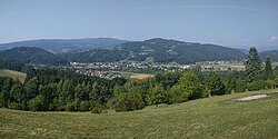
View of the village of Krottendorf-Gaisfeld (center), Krottendorfberg (center top), and parts of Gaisfeld (right) from Muggauberg.
Austria adm location map.svg
Red pog.svg
Krottendorf-Gaisfeld
Location within Austria
Coordinates: 47°00′33″N15°12′57″E / 47.00917°N 15.21583°E / 47.00917; 15.21583 Coordinates: 47°00′33″N15°12′57″E / 47.00917°N 15.21583°E / 47.00917; 15.21583
Country Austria
State Styria
District Voitsberg
Government
   Mayor Johann Feichter (ÖVP)
Area
[1]
  Total17.02 km2 (6.57 sq mi)
Population
 (2018-01-01) [2]
  Total2,463
  Density140/km2 (370/sq mi)
Time zone UTC+1 (CET)
  Summer (DST) UTC+2 (CEST)
Postal code
8564
Area code 03143
Vehicle registration VO
Website www.krottendorf-gaisfeld.at

Krottendorf-Gaisfeld is a municipality in the district of Voitsberg in the Austrian state of Styria.

Geography

The municipality lies west of Graz.

Related Research Articles

Schwarzach, Vorarlberg Place in Vorarlberg, Austria

Schwarzach is a municipality in the Austrian state of Vorarlberg.

Bildstein Place in Vorarlberg, Austria

Bildstein is a municipality in the district of Bregenz in the Austrian state of Vorarlberg.

Andelsbuch Place in Vorarlberg, Austria

Andelsbuch is a municipality in the district of Bregenz in the Austrian state of Vorarlberg.

Warth, Vorarlberg Place in Vorarlberg, Austria

Warth is a municipality in the district of Bregenz in the Austrian state of Vorarlberg.

Lorüns Place in Vorarlberg, Austria

Lorüns is a municipality in the district of Bludenz in the Austrian state of Vorarlberg.

Ludesch Place in Vorarlberg, Austria

Ludesch is a municipality in the district of Bludenz in the Austrian state of Vorarlberg.

Raggal Place in Vorarlberg, Austria

Raggal is a municipality in the district of Bludenz in the Austrian state of Vorarlberg.

Sankt Gallenkirch Place in Vorarlberg, Austria

Sankt Gallenkirch is a municipality in the district of Bludenz in the Austrian state of Vorarlberg.

Sankt Gerold Place in Vorarlberg, Austria

Sankt Gerold is a municipality in the district of Bludenz in the Austrian state of Vorarlberg.

Silbertal Place in Vorarlberg, Austria

Silbertal is a municipality in the district of Bludenz in the Austrian state of Vorarlberg.

Sonntag, Austria Place in Vorarlberg, Austria

Sonntag is a municipality in the district of Bludenz in the Austrian state of Vorarlberg.

Stallehr Place in Vorarlberg, Austria

Stallehr is a municipality in the district of Bludenz in the Austrian state of Vorarlberg.

Thüringerberg Place in Vorarlberg, Austria

Thüringerberg is a municipality in the district of Bludenz in the Austrian state of Vorarlberg.

Höchst, Austria Place in Vorarlberg, Austria

Höchst is a municipality in the district of Bregenz in the Austrian state of Vorarlberg.

Schnepfau Place in Vorarlberg, Austria

Schnepfau is a municipality in the district of Bregenz in the Austrian state of Vorarlberg.

Dünserberg Place in Vorarlberg, Austria

Dünserberg is a municipality in the district of Feldkirch in the Austrian state of Vorarlberg.

Röns Place in Vorarlberg, Austria

Röns is a municipality in the district of Feldkirch in the Austrian state of Vorarlberg.

Röthis Place in Vorarlberg, Austria

Röthis is a municipality in the district of Feldkirch in the Austrian state of Vorarlberg.

Schnifis Place in Vorarlberg, Austria

Schnifis is a municipality in the district of Feldkirch in the Austrian state of Vorarlberg.

Altschwendt Place in Upper Austria, Austria

Altschwendt is a municipality in the district of Schärding in the Austrian state of Upper Austria.

References

  1. "Dauersiedlungsraum der Gemeinden Politischen Bezirke und Bundesländer - Gebietsstand 1.1.2018". Statistics Austria. Retrieved 10 March 2019.
  2. "Einwohnerzahl 1.1.2018 nach Gemeinden mit Status, Gebietsstand 1.1.2018". Statistics Austria. Retrieved 9 March 2019.