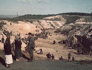
Babi Yar or Babyn Yar is a ravine in the Ukrainian capital Kyiv and a site of massacres carried out by Nazi Germany's forces during its campaign against the Soviet Union in World War II. The first and best documented of the massacres took place on 29–30 September 1941, killing some 33,771 Jews. The decision to murder all the Jews in Kyiv was made by the military governor Generalmajor Kurt Eberhard, the Police Commander for Army Group South, SS-Obergruppenführer Friedrich Jeckeln, and the Einsatzgruppe C Commander Otto Rasch. Sonderkommando 4a as the sub-unit of Einsatzgruppe C, along with the aid of the SD and Order Police battalions with the Ukrainian Auxiliary Police backed by the Wehrmacht, carried out the orders. Sonderkommando 4a and the 45th Battalion of the German Order Police conducted the shootings. Servicemen of the 303rd Battalion of the German Order Police at this time guarded the outer perimeter of the execution site.

The Kyiv TV Tower is a 385 m-high (1,263 ft) lattice metal tower on Oranzhereina Street, Kyiv, Ukraine, and is the tallest structure in the country. The tower was built in 1973 while Kyiv was the capital of Ukraine SSR. The tower was the tallest free-standing metal structure in the world until being surpassed by the Tokyo Skytree in 2012. It is used for radio and television broadcasting and is not open to the public.

Kyiv or Kiev is the capital and most populous city of Ukraine. It is in north-central Ukraine along the Dnieper River. As of 1 January 2021, its population was 2,962,180, making Kyiv the seventh-most populous city in Europe.

Dnipro, previously called Dnipropetrovsk from 1926 until May 2016, is Ukraine's fourth-largest city, with about one million inhabitants. It is located in the eastern part of Ukraine, 391 km (243 mi) southeast of the Ukrainian capital Kyiv on the Dnieper River, after which it is named. Dnipro is the administrative centre of the Dnipropetrovsk Oblast. It hosts the administration of Dnipro urban hromada, one of the hromadas of Ukraine. It has a population of 980,948.

The oblasts or regions of Ukraine, of which there are 24, are the main type of first-level administrative division of Ukraine, the other types being an autonomous republic (Crimea) and two cities with special status. Ukraine is a unitary state, thus the oblasts do not have much legal scope of competence other than that which is established in the Ukrainian Constitution and by law. Articles 140–146 of Chapter XI of the constitution deal directly with local authorities and their competency.
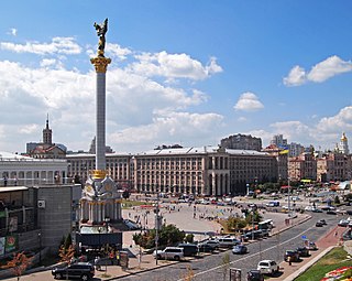
Maidan Nezalezhnosti is the central square of Kyiv, the capital city of Ukraine. One of the city's main squares, it is located on Khreshchatyk Street in the Shevchenko Raion. The square has been known under many different names, but often it is called by people simply Maidan ("square"). The square contains the iconic Independence Monument.

Obolonskyi District is an urban district of the Ukrainian capital Kyiv. Obolonskyi District encompasses territories far beyond of its historical neighborhood sharing the same name. It was formed on 3 March 1975 and initially called as Minskyi District. In 2001 it was renamed to its historical name. Its current population is 290,000 inhabitants.
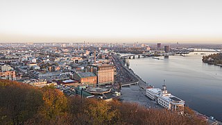
Podil or Podol or the Lower city is a historic neighborhood in Kyiv, the capital of Ukraine. It is located on a floodplain terrace over the Dnieper between the Kyiv Hills and the lower stream of Pochaina River. Podil is one of the oldest neighborhoods of Kyiv, and the birthplace of the city's trade, commerce and industry. After the Mongol invasion of Rus' and destruction of Kyiv, it served as a city center until the 19th century. Here the city administration (magistrate) and the main university were located, and later the city's port and shipyard were established here.

Khreshchatyk is the main street of Kyiv, Ukraine. The street has a length of 1.2 kilometres (0.75 mi). It stretches from the European Square (northeast) through the Maidan and to Bessarabska Square (southwest) where the Besarabsky Market is located. Along the street are the offices of the Kyiv City Council which contains both the city's council and the state administration, the Main Post Office, the Ministry of Agrarian Policy, the State Committee of Television and Radio Broadcasting, the Central Department Store (TsUM), the Ukrainian House, and others.

Bakhmut in 1924-2016: Artemivsk or Artyomovsk, is a city and the administrative centre of Bakhmut Raion in the Donetsk Oblast of Ukraine. On 4 February 2016 the Verkhovna Rada of Ukraine confirmed the name change of the city by returning to the original one. Prior to 2020, Bakhmut was a city of regional significance. It is located on the Bakhmutka River about 89 km away from the administrative center of the Donetsk Oblast, Donetsk. Population: 72,310
Holosiivskyi District is an urban district of the city of Kyiv, the capital of Ukraine.

Dorohozhychi is a Kyiv Metro station on the Syretsko-Pecherska Line. Opened on 30 March 2000, the station represents the second extension of the Syretsky radius to the northwest. It is located nearby the territory of Babyn Yar.
Solomianskyi District is a district in Kyiv, the capital of Ukraine. Located in the western part of the city, in the basin of Lybid river, Dniepr's tributary. Named after village of Solomianka that became part of Kyiv in 1858. Established as a district in 1921. Reogarnized in 2001. An area of the district was settled since the Middle Ages. The so-called mount of Batu Khan who invaded Kyiv in 1240 is located within the district.
The Shevchenkivskyi District is an urban district of the city of Kyiv, the capital of Ukraine. It was originally established on 4 April 1937, although in 2001 its area was increased following an annexation of the former Radianskyi and StaroKyivskyi districts.

The Arch of Freedom of the Ukrainian people is a monument in Kyiv, the capital of Ukraine. It was opened on 7 November 1982, to commemorate the 60th Anniversary of the USSR and the celebration of the 1,500th Anniversary of Kyiv.
Babi Yar, a ravine near Kyiv, was the scene of possibly the largest shooting massacre during the Holocaust. After the war, commemoration efforts encountered serious difficulty because of the policy of the Soviet Union. After the dissolution of the Soviet Union, a number of memorials have been erected. The creation of the Babyn Yar Holocaust Memorial Center was initiated in 2016.

Constitution Square is a square restricted to pedestrians only and located in the very center of Kyiv city, Pechersk neighborhood of the Pechersk Raion.
Mykhailo Hrushevskyi Street or simply Hrushevskyi Street is a street in central Kyiv, the capital of Ukraine.

Decommunization in Ukraine started during and after the dissolution of the Soviet Union in 1991. With the success of the Revolution of Dignity in 2014, the Ukrainian government approved laws that outlawed communist symbols.
Derussification in Ukraine is a process of removing Russian influence from the country of Ukraine. This includes getting rid of the effects of the colonial past, which began during the collapse of the Russian Empire, but was interrupted, partly during the policy of indigenization, and finally resumed after the collapse of the USSR and intensified during the demolition of Lenin monuments during the Euromaidan and further systemic process of decommunization in Ukraine. The main impetus for the revival of the process was also the Russo-Ukrainian War. As of April 8, 2022, according to a poll by the sociological group Rating, 76% of Ukrainians support the initiative to rename streets and other objects whose names are associated with Russia.
