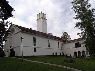
Muurame is a municipality of Finland, located 16 kilometres (10 mi) south-west of Jyväskylä. Muurame itself is located between two lakes, Lake Päijänne and Lake Muuratjärvi. These two lakes are connected to each other via River Muurame. All together there are 37 lakes in Muurame. Biggest lakes beside Päijänne are Muuratjärvi and Lake Kuusjärvi. River Muurame streams through the population center of Muurame. Muurame was founded in 1921.
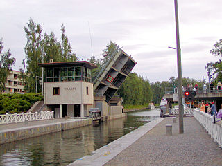
Asikkala is a municipality of Finland. Its seat is in Vääksy, at the shores of the Lake Päijänne. It is located in the province of Southern Finland and is part of the Päijänne Tavastia region. Asikkala's neighboring municipalities are Hämeenlinna, Heinola, Hollola, Lahti, Padasjoki and Sysmä.
Äänekoski is a town in Finland. It is located in the Central Finland region, about 45 kilometres (28 mi) north of Jyväskylä, the region's capital city. Äänekoski has a population of 17,818, as of 31 October 2024, and covers an area of 1,138.39 square kilometres (439.53 sq mi) of which 253.84 km2 (98.01 sq mi), or 22%, is water. The population density is 20.14 inhabitants per square kilometre (52.2/sq mi).

Taivalkoski is a municipality of Finland, it is located in the Province of Oulu and is part of the Northern Ostrobothnia region.

Hankasalmi is a municipality of Finland, located in the Central Finland region. The municipality has a population of 4,515 (31 October 2024) and covers an area of 687.75 square kilometres (265.54 sq mi) of which 115.89 km2 (44.75 sq mi) is water. The population density is 7.9 inhabitants per square kilometre (20/sq mi).
Hartola is a municipality of Finland. It is located in the Itä-Häme, Päijänne Tavastia region. The municipality has a population of 2,503 (31 October 2024), which make it the smallest municipality in Päijänne Tavastia in terms of population. It covers an area of 675.38 square kilometres (260.77 sq mi) of which 132.18 km2 (51.03 sq mi) is water. The population density is 4.61 inhabitants per square kilometre (11.9/sq mi). Neighbouring municipalities are Heinola, Joutsa, Luhanka, Pertunmaa and Sysmä.

Joroinen is a municipality in the North Savo region of Finland. It is located in the province of Eastern Finland and is part of the Northern Savonia sub-region. The municipality has a population of approximately 4,626 people and covers an area of 982 square kilometers.
Joutsa is a municipality of Finland. It is located in the province of Western Finland and is part of the Central Finland region. Jyväskylä is located about 70 kilometres (43 mi) north of the Joutsa municipality.

Kinnula is a municipality of Finland.

Outokumpu is a town and municipality of Finland. It is located in the North Karelia region, 48 kilometres (30 mi) west of Joensuu and 92 kilometres (57 mi) east of Kuopio. The municipality has a population of 6,440 and covers an area of 584.05 square kilometres (225.50 sq mi) of which 138.22 km2 (53.37 sq mi) is water. The population density is 14.44 inhabitants per square kilometre (37.4/sq mi). The most important road connection in the locality is Highway 9.
Kärkölä is a municipality of Finland. It is located in the province of Southern Finland and is part of the Päijänne Tavastia region. The municipality has a population of 4,094 and covers an area of 259.30 square kilometres (100.12 sq mi) of which 2.84 km2 (1.10 sq mi) is water. The population density is 15.96 inhabitants per square kilometre (41.3/sq mi). Its seat is in Järvelä, which is located along the Riihimäki–Lahti railway.

Laukaa is a municipality of Finland. It is located next to Jyväskylä and is part of the Central Finland region. The municipality has a population of 18,869 and covers an area of 825.59 square kilometres (318.76 sq mi) of which 177.09 km2 (68.37 sq mi) is water. The population density is 29.1 inhabitants per square kilometre (75/sq mi).

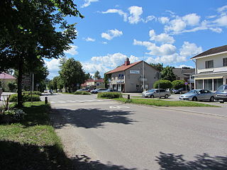
Luhanka is a municipality of Finland. It is located in the Central Finland region. The municipality has a population of 703 and covers an area of 313.25 square kilometres (120.95 sq mi) of which 98.73 km2 (38.12 sq mi) is water.

Orivesi is a town in Finland, located in the Pirkanmaa region. It lies to the northeast of the regional capital, Tampere. The population of Orivesi is approximately 9,000, while the metropolitan area has a population of approximately 423,000. It is the 111th most populous municipality in Finland.

Padasjoki is a municipality of Finland. It is located in the province of Southern Finland and is part of the Päijänne Tavastia region. It is 53 kilometres (33 mi) from Padasjoki to Lahti and 65 kilometres (40 mi) to Heinola. The municipality has a population of 2,687 and covers an area of 729.85 square kilometres (281.80 sq mi) of which 206.68 km2 (79.80 sq mi) is water. The population density is 5.14 inhabitants per square kilometre (13.3/sq mi).
Ruovesi is a municipality of Finland.

Saarijärvi is a town and municipality of Finland located in the Central Finland region. The municipality has a population of 8,837, as of 31 October 2024, and covers an area of 1,422.72 square kilometres (549.32 sq mi) of which 170.8 km2 (65.9 sq mi), or 12%, is water. The population density is 7.06 inhabitants per square kilometre (18.3/sq mi).

Sysmä is a municipality of Finland. It is situated in the Päijät-Häme region. The municipality has a population of 3,435 (31 October 2024) and covers an area of 936.18 square kilometres (361.46 sq mi) of which 269.14 km2 (103.92 sq mi) is water. The population density is 5.15 inhabitants per square kilometre (13.3/sq mi). Neighbouring municipalities are Asikkala, Hartola, Heinola, Kuhmoinen, Luhanka, and Padasjoki. The municipality is unilingually Finnish.

Toivakka is a municipality of Finland. It is located in the Central Finland region, near Jyväskylä. The municipality has a population of 2,361 (31 October 2024) and covers an area of 413.94 square kilometres (159.82 sq mi) of which 52.44 km2 (20.25 sq mi) is water. The population density is 6.53 inhabitants per square kilometre (16.9/sq mi). The municipality is unilingually Finnish.

Viitasaari is a Finnish town and municipality located in the Central Finland region. It is located between the neighbouring municipalities of Pihtipudas to the north and Äänekoski to the south. The town has a population of 5,757 (31 October 2024) and covers an area of 1,589.13 square kilometres (613.57 sq mi) of which 340.43 km2 (131.44 sq mi), or 21%, is water. There are all together 230 lakes in Viitasaari. The biggest lakes are Lake Keitele, Lake Kolima and Muuruejärvi. The population density is 4.61 inhabitants per square kilometre (11.9/sq mi).


