Kuiseb River

Last updated
Kuiseb River
Kuiseb Namibia anagoria.JPG
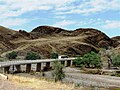
The Kuiseb River during rain season
NEO kuiseb.jpeg
Satellite image of the Kuiseb River
Location
Country Namibia
Regions Khomas, Erongo
Physical characteristics
Sourcewest of Windhoek
  location Khomas Highland
Mouth Atlantic Ocean
  location
Walvis Bay
  coordinates
23°07′S14°32′E / 23.117°S 14.533°E / -23.117; 14.533
  elevation
0 m (0 ft)
Lengthc. 480 km (300 mi)
Basin size15,500 km2 (6,000 sq mi)
Discharge 
  averagec. 20 million cubic metres per annum (710×10^6 cu ft/a)
Basin features
Tributaries 
  left Gomab River, Ojab River, Chausib River, Gaub River
  right Koam River, Nausgomab River, Goagos River
Waterbodies Friedenau Dam

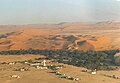
The Kuiseb River is an ephemeral river in western-central Namibia. Its source is in the Khomas Highland west of Windhoek. From there it flows westwards through the Namib-Naukluft National Park and the Namib desert to Walvis Bay. Several settlements of the Topnaar people are on the banks of the lower Kuiseb, for instance Homeb, Sandfontein, Rooibank, and Utuseb. [1] [2] Inflows of the Kuiseb are Gomab, Ojab, Chausib, Gaub, Koam, Nausgomab and Goagos. [3]

Contents

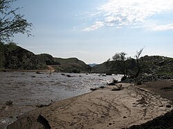
The Kuiseb's catchment area (including its tributaries) is estimated to be between 15,500 [3] and 16,692 km2 (6,445 sq mi). [4] It has a mean run-off of roughly 20 million cubic metres per annum (710×10^6 cu ft/a). [5] Friedenau Dam, built in 1972, is on the river. [6] In January 2005, for the first time in years, the Kuiseb flowed to the ocean.

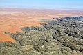
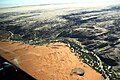
Between Naukluft and Namib the Kuiseb carved out a canyon in a barren and inaccessible area. During World War II the area around the Kuiseb Canyon served as a shelter for Henno Martin and Hermann Korn who moved there to wait the war out. [7] Two books and a film were subsequently published about this 2-year stay; the ruins of their shelter can be visited. On its course through the Namib the Kuiseb is bordered on one side by some of the tallest sand dunes in the world, and on the other by barren rock. [3] The red sand dunes south of the river reach heights over 150 meters. The prevailing winds blow the dunes northward, but their movement is blocked by the river. In the process, so much sand and silt is deposited in the Kuiseb that it only reaches the sea while it is in flood. [8]

In 1907, the area between the Swakop River and the Kuiseb was designated by the German colonial administration as a game reserve. The area is currently part of the Namib-Naukluft National Park. The Desert Research Foundation of Namibia (DRFN) is located at Gobabeb on the banks of the river. [9]

See also

Related Research Articles

<span class="mw-page-title-main">Geography of Namibia</span>

At 824,292 km2 (318,261 sq mi), Namibia is the world's thirty-fourth largest country. After Mongolia, Namibia is the second least densely populated country in the world. Namibia got its name from the Namib desert that stretches along the coast of the Atlantic. It is also known for its wildlife.

<span class="mw-page-title-main">Namib</span> Desert in Southern Africa

The Namib is a coastal desert in Southern Africa. According to the broadest definition, the Namib stretches for more than 2,000 kilometres (1,200 mi) along the Atlantic coasts of Angola, Namibia, and northwest South Africa, extending southward from the Carunjamba River in Angola, through Namibia and to the Olifants River in Western Cape, South Africa. The Namib's northernmost portion, which extends 450 kilometres (280 mi) from the Angola-Namibia border, is known as Moçâmedes Desert, while its southern portion approaches the neighboring Kalahari Desert. From the Atlantic coast eastward, the Namib gradually ascends in elevation, reaching up to 200 kilometres (120 mi) inland to the foot of the Great Escarpment. Annual precipitation ranges from 2 millimetres (0.079 in) in the aridest regions to 200 millimetres (7.9 in) at the escarpment, making the Namib the only true desert in southern Africa. Having endured arid or semi-arid conditions for roughly 55–80 million years, the Namib may be the oldest desert in the world and contains some of the world's driest regions, with only western South America's Atacama Desert to challenge it for age and aridity benchmarks.

<span class="mw-page-title-main">Namib-Naukluft National Park</span> National park in Namibia

The Namib-Naukluft Park is a national park in western Namibia, situated between the coast of the Atlantic Ocean and the edge of the Great Escarpment. It encompasses part of the Namib Desert, the Naukluft mountain range, and the lagoon at Sandwich Harbour. The best-known area of the park and one of the main visitor attractions in Namibia is Sossusvlei, a clay pan surrounded by dunes, and Sesriem, a small canyon of the Tsauchab. The desert research station of Gobabeb is situated within the park.

<span class="mw-page-title-main">Solitaire, Namibia</span> Place in Khomas Region, Namibia

Solitaire is a small settlement in the Khomas Region of central Namibia near the Namib-Naukluft National Park. It currently features the only gasoline station, bakery, cafe, and the only general dealer between the dunes at Sossusvlei and the coast at Walvis Bay, as well as on the road to the capital Windhoek. Solitaire belongs to the Windhoek Rural electoral constituency.

<span class="mw-page-title-main">Sossusvlei</span> Salt and clay pan in the Namib Desert, Namibia

Sossusvlei is a salt and clay pan surrounded by high red dunes, located in the southern part of the Namib Desert, in the Namib-Naukluft National Park of Namibia. The name "Sossusvlei" is often used in an extended meaning to refer to the surrounding area. These landmarks are some of the major visitor attractions of Namibia.

<span class="mw-page-title-main">Swakop River</span> River in Namibia

The Swakop River is a major river in western central Namibia. Its source is in the Khomas Highland. From there it flows westwards through the town of Okahandja, the historic mission station at Gross Barmen, and the settlement of Otjimbingwe. It then crosses the Namib desert and reaches the Atlantic Ocean at Swakopmund. The Swakop is an ephemeral river; its run-off is roughly 40 million cubic metres per annum.

<span class="mw-page-title-main">Tsauchab</span> River in central Namibia

The Tsauchab is an ephemeral river in the Hardap Region of central Namibia. Its source is in the southern Naukluft Mountains, from where it flows westwards through the Namib-Naukluft National Park into Sossusvlei, an endorheic basin. The lower river has in the past had a slightly different courses and also formed two other basins, the Deadvlei and the Hiddenvlei.

<span class="mw-page-title-main">Gobabeb</span> Research station in the Namib Desert

The Gobabeb Namib Research Institute, short: Gobabeb, is a centre for dry land training and research in Namibia. It is located in the Namib Desert, 120 kilometres (75 mi) south-east of Walvis Bay.

<span class="mw-page-title-main">Tourism in Namibia</span> Economic sector in Namibia

Tourism in Namibia is a major industry, contributing N$7.2 billion to the country's gross domestic product. Annually, over one million travelers visit Namibia, with roughly one in three coming from South Africa, then Germany and finally the United Kingdom, Italy and France. The country is among the prime destinations in Africa and is known for ecotourism which features Namibia's extensive wildlife.

<span class="mw-page-title-main">Khan River</span> River

The river Khan is an ephemeral river crossing the Erongo region of central Namibia. It is the main tributary of the Swakop River and only occasionally carries surface water during the rainy season from November to February/March. Khan's catchment area including its tributaries Slang and Etiro stretches over 8,400 square kilometres (3,200 sq mi).

Henno Martin was a German professor of geology who, along with Hermann Korn, lived for two years in the Namib Desert to avoid internment during the Second World War.

Acanthoproctus diadematus is an armoured katydid, bush-cricket, or ground cricket endemic to the Namib Desert of southern Africa, where it lives in the tall sand dunes along the Kuiseb River in Namib-Naukluft National Park. The katydid feeds on the !nara melon endemic to the area.

<span class="mw-page-title-main">Omaruru River</span> River

The Omaruru River is a major river crossing the Erongo Region of western central Namibia from East to West. It originates in the Etjo Mountains, crosses the town of Omaruru and the village of Okombahe, and reaches the sea a few kilometers north of Henties Bay. Inflows of the Omaruru are Otjimakuru, Goab, Spitzkop, Leeu and Okandjou.

Utuseb is a small settlement in the Erongo Region in western central Namibia. It is situated in the Namib Desert, approximately 40 kilometres (25 mi) from Walvis Bay on the banks of Kuiseb River. Utuseb has approximately 700 inhabitants and belongs to the Walvis Bay Rural electoral constituency. The people living here belong to the ǂAonin community, a subtribe of the Nama people.

<span class="mw-page-title-main">Hoanib</span> Ephemeral seasonal river in Namibia

The Hoanib is one of the 12 ephemeral seasonal rivers in the west of Namibia, where it used to be the border between northern Damaraland and Kaokoland. Its length is 270 km. With the low population density in the area, the oasis character of the river valley and the relatively high wildlife population of the Hoanib, like in the case of the Hoarusib, its valley is one of the last true wilderness areas in Namibia. One of the last settlements of desert elephants, it is characterised by strong wind and water eroded, weathered stone deposits. Inflows of Hoanib are Aap River, Otjitaimo River, Ombonde, Ganamub, Mudorib and Tsuxub.

<span class="mw-page-title-main">Dorob National Park</span> National park of Namibia

The Dorob National Park is a protected area in the Erongo region, along the central Namibian coast, which is 1,600 kilometres (990 mi) in length. It was gazetted as a national park under the Nature Conservation Ordinance No.4 of 1975 on 1 December 2010, and with Namib-Naukluft Park it covers an area of 107,540 square kilometres (41,520 sq mi).

The Topnaar people (ǂAonin) are a clan of the Nama people in Namibia. Their settlements are all situated on the Kuiseb River in the Erongo Region of central Namibia, the largest one is Utuseb.

<span class="mw-page-title-main">Khumib River</span> River

The river Khumib is an ephemeral river crossing the Kunene Region of north-western Namibia. It occasionally carries surface water during the rainy seasons in November and February/March. Its catchment area is estimated between 2200 and 2,300 square kilometres (890 sq mi).

<span class="mw-page-title-main">Huab River</span> River

The Huab River is an ephemeral river in the Kunene Region of north-western Namibia. Its source is southeast of Kamanjab, from where it flows westwards through Mopane savanna until it reaches the Skeleton Coast and the Atlantic Ocean. Inflows of the Huab are Klein-Omaruru, Sout, Aba-Huab, Ongwati and Klip. Huab's catchment area is estimated to be between 14,800 and 16,465 km2 (6,357 sq mi), and includes the town of Khorixas as well as the settlements Kamanjab, Fransfontein, and Anker. The Twyfelfontein World Heritage Site is located on the banks of the Aba Huab.

<span class="mw-page-title-main">Tsondab River</span> River in central Namibia

The Tsondab River is an ephemeral river in the Hardap Region of central Namibia. Its source is in the Remhoogte Mountains. From there it flows westwards through the Namib-Naukluft National Park before evaporating at Tsondabvlei. Inflows of the Tsondab are Diep, Noab and Koireb. Tsondab's catchment area is 3,500 km2 (1,400 sq mi).

References

Notes

  1. Malan 1998, p. 120–125.
  2. Moritz 1997, pp. 4–5.
  3. 1 2 3 Jacobson, Peter J.; Jacobson, Kathryn M.; Seely, Mary K. (1995). Ephemeral rivers and their catchments: Sustaining people and development in western Namibia (PDF 8.7MB). Windhoek: Desert Research Foundation of Namibia. pp. 140–141. ISBN   9991670947.
  4. Strohbach, B.J. (2008). "Mapping the Major Catchments of Namibia" (PDF 1.0MB). Agricola. 2008: 63–73. ISBN   9780353358164. ISSN   1015-2334. OCLC   940637734.
  5. "ELECTIONS 2010: Erongo regional profile". New Era. 16 November 2010. Archived from the original on 6 September 2012.
  6. Friedenau Archived 2008-11-21 at the Wayback Machine at NamWater
  7. Martin, Henno (2006). The Sheltering Desert. Hamburg: Two Books. ISBN   9783935453035.
  8. Morin, Efrat; Grodek, Tamir; Dahan, Ofer; Benito, Gerardo; Kulls, Christoph; Jacoby, Yael; Langenhove, Guido Van; Seely, Mary; Enzel, Yehouda (April 2009). "Flood routing and alluvial aquifer recharge along the ephemeral arid Kuiseb River, Namibia". Journal of Hydrology. 368 (1–4): 262–275. doi:10.1016/j.jhydrol.2009.02.015. ISSN   0022-1694.
  9. "Desert Research Foundation of Namibia". namibweb.com. Retrieved 3 October 2019.

Literature

Videos