Kulusuk Island

Last updated
Kulusuk
Kulusuk-island-sketchmap.svg
Geography of Kulusuk Island
Kulusuk Island
Location of Kulusuk Island
Geography
Location North Atlantic
Coordinates 65°33′N37°07′W / 65.550°N 37.117°W / 65.550; -37.117 Coordinates: 65°33′N37°07′W / 65.550°N 37.117°W / 65.550; -37.117
Administration
Greenland
Municipality Sermersooq

Kulusuk Island (Greenlandic : Kulusup qeqertaa) is an island in the Sermersooq municipality on the southeastern shore of Greenland. [1] It is an outlying island in the Ammassalik archipelago of islands on the coast of the North Atlantic. The island is home to Kulusuk, the fourth-largest settlement on the entire eastern coast of Greenland. [2] The island has an area of 41.98 km2, and measures 8 km (5.0 mi) from north to south and 11 km (6.8 mi) from west to east. The Kulusuk Airport on the island is one of the two airports on the entire eastern Greenland coast.

Contents

History

Among the archaeological ruins on Kulusuk the ancient settlement of Ikaasap Ittiva (Ikâsap Igtiva) is located near the shore at the northern end of the island. This site belongs to the oldest phase of the Saqqaq culture, around 2000 BCE. [3]

Geography

Noorajik cape seen from the open-air winter bivouac on the shore of the icebound Tiivtingaleq bay. Kulusuk-tiivtingaleq-icebound.jpg
Noorajik cape seen from the open-air winter bivouac on the shore of the icebound Tiivtingaleq bay.

The island is hilly throughout, with several distinct mountains dominating the eastern and southern coast. The southernmost point is the Naujaangivit cape (Danish : Kap Dan [4] − a name often extended to the settlement or the island) under the Isikajia mountain (336 m (1,102.4 ft)). [4]

To the northeast the island is separated from the Apusiaajik Island by the Ikaasaartik Strait. In the north, the Torsuut Tunoq sound separates it from the small, uninhabited Akinaaq island, ultimately linking it to the Ammassalik Fjord in the northwest. [1] To the south and east the island shores are washed by the icy waters of the North Atlantic, through which flows the East Greenland Current.

Promontories

NameDirectionLatitude NLongitude W
NoorajikNorthwestern Cape65°33′55″37°13′30″
(none)Northern Cape65°35′09″37°07′40″
KangeqSoutheastern Cape65°32′10″37°01′20″
NaujaangivitSouthern Cape65°31′07″37°10′58″

Coast

Interior of Kulusuk Island Kulusuk-island.jpg
Interior of Kulusuk Island

The coast of most of the island is mostly undeveloped, with the mountain walls and slopes falling directly into the ocean. In the west there are several small peninsulas and bays. The largest of the latter is Tiivtingaleq bay to the southwest of the settlement, host to a small harbour used both in all seasons as a starting point for hunting trips.

A group of tiny skerries surrounds the coastline in the west, as well as in the north in the vicinity of the village. From north to south, the western skerries are: Sitte, Puullortuluk, Ittitalik, Ittive, and Saattit. [1]

Mountains

Pinnacle in the northwestern ridge of Qalorujoorneq Qalorujoorneq-pinnacle.jpg
Pinnacle in the northwestern ridge of Qalorujoorneq

The island is hilly, and unlike its immediate neighbours, not glaciated, albeit covered with ice for more than half of the year. The highest point on the island is the summit of Qalorujoorneq, at 676 m (2,217.8 ft) [4] topping a wide mountain massif in the southeast, directly above the Kulusuk Airport. Qalorujoorneq has three ridges. Its southeastern ridge extends to the southeastern promontory on the island, with two distinct peaks: Saajat at 603 metres (1,978 ft) and Kangeq at 280 metres (919 ft). [4]

Lakes

There is one larger lake on the island, Qalorujoornep Tasia, located in a post-glacial cirque in the heart of the island directly west of the western wall of Qalorujoorneq. Its northern shore is situated just shy of the shallow saddle in the northwestern ridge of the mountain, directly above the airport. During the brief summer a stream flows to the west, to then turn north through the depression in the center of the island, to join the second-largest lake on the island, serving as a water reservoir for the settlement. [4] The reservoir empties into a smaller pond on the edge of the village just south of the coastal scarp. The outflow from the reservoir leads to the west, through a series of smaller interior lakes, draining into Tiivtingaleq bay. All lakes and streams are frozen during winter.

See also

Related Research Articles

Uummannaq Island Small island in the Qaasuitsup municipality, Greenland

Uummannaq Island is a small (12 km2) island in the Qaasuitsup municipality in northwestern Greenland. Located in the south-central part of the Uummannaq Fjord, it is home to the most prominent mountain on the Arctic coast of western Greenland and to Uummannaq, the largest town north of Ilulissat.

Ammassalik was one of two municipalities in Tunu, the former county of East Greenland − the other one being Illoqqortoormiut. It was located in southeastern Greenland, and with an area of 232,100 km2, most of it on the ice sheet, it was the largest municipality of East Greenland, now part of the new Sermersooq municipality. The population was 3,031 on 1 January 2005. Due to its size, the old municipality bordered more municipalities than any other in Greenland (10):

Sisimiut Place in Greenland, Kingdom of Denmark

Sisimiut, formerly known by its colonial name Holsteinsborg, is the capital and largest city of the Qeqqata municipality, the second-largest city in Greenland, and the largest arctic city in North America. It is located in central-western Greenland, on the coast of Davis Strait, approximately 320 km (200 mi) north of Nuuk.

Tasiilaq Place in Greenland, Kingdom of Denmark

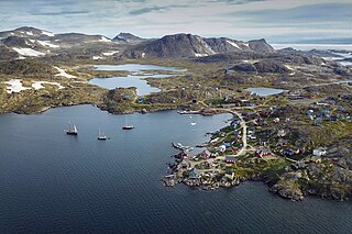
Tasiilaq, formerly Ammassalik and Angmagssalik, is a town in the Sermersooq municipality in southeastern Greenland. With 1,985 inhabitants as of 2020, it is the most populous community on the eastern coast, and the seventh-largest town in Greenland. The Sermilik Station, dedicated to the research of the nearby Mittivakkat Glacier, is located near the town.

Kulusuk Airport

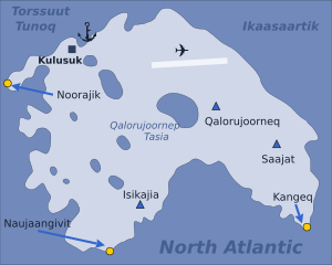
Kulusuk Airport is an airport in Kulusuk, a settlement on an island of the same name off the shore of the North Atlantic in the Sermersooq municipality in southeastern Greenland.

Kulusuk Place in Greenland, Kingdom of Denmark

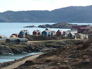
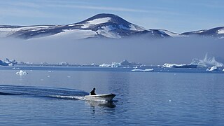
Kulusuk, formerly Kap Dan, is a settlement in the Sermersooq municipality in southeastern Greenland, located on an island of the same name. The settlement population of 241 includes many Danes choosing to live there due to the airport. In the Kalaallisut language, the name of the village means "Chest of a Black Guillemot".

Ikkatteq Place in Greenland, Kingdom of Denmark

Ikkatteq was a small village in the Sermersooq municipality in southeastern Greenland. It was abandoned in 2005.

Sermersooq Municipality of Greenland

Sermersooq is a municipality in Greenland, formed on 1 January 2009 from five earlier, smaller municipalities. Its administrative seat is the city of Nuuk, the capital of Greenland, and it is the most populous municipality in the country, with 23,123 inhabitants as of January 2020. The municipality consists of former municipalities of eastern and southwestern Greenland, each named after the largest settlement at the time of formation:

Ammassalik Fjord

Ammassalik Fjord is a 41 km (25.5 mi) long fjord in the Sermersooq municipality in southeastern Greenland.

Ammassalik Island

Ammassalik Island is an island in the Sermersooq municipality in southeastern Greenland, with an area of 772 km2 (298.1 sq mi).

Apusiaajik Island

Apusiaajik Island is an uninhabited island in the Sermersooq municipality on the southeastern shore of Greenland. It is an outlying island in the Ammassalik archipelago of islands on the coast of the North Atlantic.

Qalorujoorneq

Qalorngoorneq is a small mountain range in the eastern part of Kulusuk Island in Sermersooq Municipality, southeastern Greenland. At 676-metre-high (2,218 ft) its highest point is the highest mountain on the island.

Torsuut Tunoq

Torsuut Tunoq is a sound on the southeastern coast of Greenland. It is an inner waterway of the North Atlantic.

Qullikorsuit Island

Qullikorsuit Island is an uninhabited island in the Avannaata municipality in northwestern Greenland. It is located in the northern part of Upernavik Archipelago.

Kiatassuaq Island

Kiatassuaq Island is an uninhabited island in the northern Upernavik Archipelago in the Qaasuitsup municipality in northwestern Greenland. It marks the southern border of Melville Bay.

Qaarsorsuaq Island

Qaarsorsuaq Island is an uninhabited island in the Qaasuitsup municipality in northwestern Greenland. At 124.7 km2 (48.1 sq mi), it is one of the largest islands in the Upernavik Archipelago, located in its southern part. The name of the island means "a large rock surface" in the Greenlandic language.

Qallunaat Island

Qallunaat Island is an uninhabited island in the Avannaata municipality in northwestern Greenland.

Innaarsuit Island

Innaarsuit Island is an island in the Avannaata municipality in northwestern Greenland, home to the Innaarsuit settlement.

King Christian IX Land Region in Greenland

King Christian IX Land is a coastal area of Southeastern Greenland in Sermersooq Municipality fronting the Denmark Strait and extending through the Arctic Circle from 65°N to 70°N.

King Frederick VI Coast Region in Greenland

King Frederick VI Coast is a major geographic division of Greenland. It comprises the coastal area of Southeastern Greenland in Sermersooq and Kujalleq municipalities fronting the Irminger Sea of the North Atlantic Ocean. It is bordered by King Christian IX Land on the north and the Greenland Ice Sheet to the west.

References

  1. 1 2 3 Tasiilaq, Saga Map, Tage Schjøtt, 1992
  2. Statistics Greenland Archived 2011-08-12 at the Wayback Machine (in Danish)
  3. Møbjerg, Tinna; Robert-Lamblin, Joëlle (1989). The Settlement at Ikaasap Ittiva, East Greenland: An Ethno-archaeological Investigation. Munksgaard, 1989.
  4. 1 2 3 4 5 O'Carroll, Etain (2005). Greenland and the Arctic. Lonely Planet. pp. 204–206. ISBN   1-74059-095-3.