
A mountain chain is a row of high mountain summits, a linear sequence of interconnected or related mountains, or a contiguous ridge of mountains within a larger mountain range. The term is also used for elongated fold mountains with several parallel chains.

A mountain pass is a navigable route through a mountain range or over a ridge. Since many of the world's mountain ranges have presented formidable barriers to travel, passes have played a key role in trade, war, and both human and animal migration throughout history. At lower elevations it may be called a hill pass. A mountain pass may be formed between two volcanic peaks, or created by erosion from water or wind.

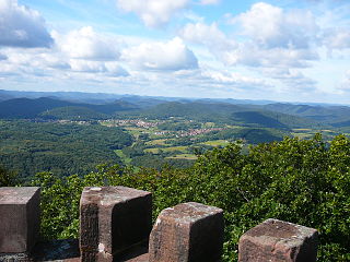
The Rhön Mountains are a group of low mountains in central Germany, located around the border area where the states of Hesse, Bavaria and Thuringia come together. These mountains, which are at the extreme southeast end of the East Hesse Highlands, are partly a result of ancient volcanic activity. They are separated from the Vogelsberg Mountains by the river Fulda and its valley. The highest mountain in the Rhön is the Wasserkuppe which is in Hesse. The Rhön Mountains are a popular tourist destination and walking area.

A fell is a high and barren landscape feature, such as a mountain or moor-covered hill. The term is most often employed in Norway, Fennoscandia, Iceland, the Isle of Man, parts of northern England, and Scotland.

Saxon Switzerland is a hilly climbing area and national park around the Elbe valley south-east of Dresden in Saxony, Germany. Together with the Bohemian Switzerland in the Czech Republic it forms the Elbe Sandstone Mountains.

The Elbe Sandstone Mountains, also called the Elbe Sandstone Highlands is a mountain range straddling the border between the state of Saxony in southeastern Germany and the North Bohemian region of the Czech Republic, with about three-quarters of the area lying on the German side. The mountains are also referred to as Saxon Switzerland and Bohemian Switzerland in both German and Czech or simply combined as Saxon-Bohemian Switzerland. In both countries, core parts of the mountain range have been declared a national park. The name derives from the sandstone which was carved by erosion. The river Elbe breaks through the mountain range in a steep and narrow valley.

A hill is a landform that extends above the surrounding terrain. It often has a distinct summit.
A little Switzerland or Schweiz is a landscape, often of wooded hills. This Romantic aesthetic term is not a geographic category, but was widely used in the 19th century to connote dramatic natural scenic features that would be of interest to tourists. Since it was ambiguous from the very beginning, it was flexibly used in travel writing to imply that a landscape had some features, though on a much smaller scale, that might remind a visitor of Switzerland.

A Mittelgebirge is a type of relatively low mountain range or highland area typical of the geography of central Europe, especially central and southern Germany; it refers to something between rolling low hill country or Hügelland and a proper mountain range like the High Alps.

The Central Uplands is one of the three major natural regions of Germany. It stretches east to west across the country. To the north lies the North German Plain or Northern Lowland; to the south, the Alps and the Alpine Foreland.
The East Hesse Highlands describes a heavily wooded range of hills lying mainly in the German state of Hesse, but also extending a little way into Lower Saxony to the north, Thuringia to the east and Bavaria to the southeast. The region is sandwiched between the West Hesse Depression to the west, the Weser Uplands to the north, the Thuringian Basin to the northeast, the northwestern edge of the Thuringian Forest to the east, the Spessart to the south and the Wetterau to the southwest.

The Thuringian Highland, Thuringian Highlands or Thuringian-Vogtlandian Slate Mountains is a low range of mountains in the German state of Thuringia.

The Gladenbach Uplands, named after their central town of Gladenbach, is a range of hills up to 609 m high in the Rhine Massif in Germany, on the junction of the Rothaar Mountains, Westerwald (southwest), (Eastern) Hintertaunus and West Hesse Highlands in the east. It lies in Central Hesse within the districts of Marburg-Biedenkopf, Lahn-Dill and Gießen within the so-called Lahn-Dill-(Dietzhölze-) loop. Small parts of the Upper Lahn Valley in the northwest belong, together with the town of Bad Laasphe, also to the district of Siegen-Wittgenstein, North Rhine-Westphalia.

The Dreistelzberg, also called the Dreistelzkopf and frequently shortened to Dreistelz, is a mountain, 660.4 m above sea level (NHN), in the Bavarian part of the Rhön Mountains.
A climbing peak may refer to a mountain or hill peak or a rock formation that has to be ascended by climbing. The term is common in Germany where it is specifically used of free-standing rock formations in the climbing regions of Saxon Switzerland, Zittau Mountains and other nearby ranges in the German Central Uplands that can only be summitted via climbing routes of at least grade I on the UIAA scale or by jumping from nearby rocks or massifs. As a general rule, they must have a topographic prominence of at least 10 metres to qualify. In Saxon Switzerland the Saxon Climbing Regulations do not require any minimum height, but define climbing peaks as
free-standing rocks that […] can only be ascending by a climb, assault (Überfall), crossing (Übertritt) or jump from nearby rocks […].
The Wasgau is a Franco-German hill range in the German state of Rhineland-Palatinate and the French departments of Bas-Rhin and Moselle. It is formed from the southern part of the Palatine Forest and the northern part of the Vosges mountains, and extends from the River Queich in the north over the French border to the Col de Saverne in the south.

A conical hill is a landform with a distinctly conical shape. It is usually isolated or rises above other surrounding foothills, and is often of volcanic origin.

The geology of Germany is heavily influenced by several phases of orogeny in the Paleozoic and the Cenozoic, by sedimentation in shelf seas and epicontinental seas and on plains in the Permian and Mesozoic as well as by the Quaternary glaciations.

The Black Mountains are part of the High Rhön in Germany, in particular of the Southern High Rhön, which lies south of the Kreuzberg Group and is thus the southernmost part of the High Rhön. Since 1993, most of the region has been protected by the Black Mountain Nature Reserve, the second largest in Bavaria outside of the Alps, in order to counteract its afforestation by coniferous forest.

The Salzungen Werra Upland is a natural region in Germany that forms part of the East Hesse Highlands in the German states of Hesse and Thuringia.
