
Ramanagara is a city in the Indian state of Karnataka. It is also the headquarters of the Ramanagara District. It is approximately 50 kilometres from Bangalore. There are buses and trains as public transportations which approximately takes 90 minutes from Bangalore.
Sindhanur is a city and taluk headquarter of Sindhanur taluk of Raichur District in Karnataka. The river Tungabhadra covers the irrigation area by left bank canal. Most of the land in the field is composed of cultivable black soil. Paddy is cultivated using the Tungabhadra River water. Sindhanur is also known as the Paddy Granary of Raichur. With the availability of Tungabhadra river water, paddy rice is grown twice a year. Sindhanur is the place where the majority of tractor sales take place in Asia. as agricultural activities take place year-round. Sona Masuri and Basmati rice are grown in Sindhanur.Amba Matha also spelled as Amba Mutt is a village near Somalapura in the Sindhanur taluk. Amba Matha is a holy place, Sri Amba Devi Temple is located in the village.
Malur is a town and taluk headquarters in Kolar district of the Indian state of Karnataka. It is 30 km from Kolar, the district headquarters, and about 50 km from Bangalore. It is accessible from Bangalore by road and railways. The Chennai Central-Bangalore City line passes through Malur, with trains to various parts of India, including Tirupati, Chennai, Kochi, Trivandrum, Patna and Calcutta.
Mulabagilu is a town and administrative center of Mulabagilu taluk, in the Kolar district in the state of Karnataka, India. The town is situated on the National Highway 75 and is the easternmost town of the state.
Chikkaballapur is the district headquarters of the newly created Chikkaballapur district in the state of Karnataka, India, which was carved out from Kolar district. It is located within 3 km of Muddenahalli. A $400 million Pharmaceutical SEZ is coming up in Chikkaballapur on 325 acres (1.32 km2), the first of its kind in India. Furthermore, the noted Traveler Bunglow is being converted into a state-of-the-art bus terminus. A new district government headquarters and police headquarters is being constructed at a cost of $5 million. In addition, the state government is releasing over $10 million to develop the city and expand underground sanitary systems. It is a regional transport and educational hub, and is a major site for grape, grain, and silk cultivation"

Kolar or Kolara is a city in the Indian state of Karnataka. It is the headquarters of Kolar district. The city is known for its milk production and gold mines. It is also known for the Someshwara and Kolaramma temples.
Nyamati is taluk place located in Davangere District of the Karnataka state, India. It is approximately 65 km south of Davangere and 26 km north of Shivamogga.
Yadgiri is a city and the administrative headquarters of Yadgir district in the Indian state of Karnataka. It is also the administrative headquarters of Yadgir Taluka, one of the six taluks of Yadgir.

Holenarasipura is a town and taluk in Hassan district of Karnataka. The town is situated on the banks of the Hemavati, one of the tributaries of the Kaveri.
Kanakapura is a city in the Ramanagara district of Karnataka on the banks of the Arkavathi river and the administrative center of the taluk of the same name. Its founder is Shrihan Kanaka Sigmanath, hence its name. Kanakapura is largest cocoon silk producer in India. River Cauvery flows around 21 km in Kanakapura Taluk. Previously belonged to Bangalore Rural District. It was formerly the largest constituency in the country. (1,553 km2 [600 sq mi]). It is located among the lush green forests of the state of Karnataka. The town is infamous with the traffic of Kanakpura Road in Benglaluru, one of the most narrow and traffic-prone roads of the state. The town is a tourism hotspot and an often visited tourist favorite in the entire state of Karnataka, as it has something for everyone ranging from avid trekkers to history buffs and wildlife enthusiasts. The forest area in this taluk is very wide and about half of the Bannerghatta National Park is located in our Kanakapura area. Kodihalli wildlife range and harohalli wildlife range its division. The Kaveri Wildlife Sanctuary consists of two main zones namely the Sangam Wildlife range, the Muggur Wildlife range.
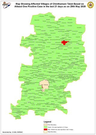
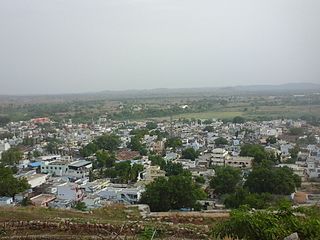
Chintamani is a Taluk Headquarters in the Indian state of Karnataka. Located on the Deccan Plateau in the south-eastern part of Karnataka. Chintamani is one of the well planned and developed Towns in the District of Kolar and presently Chikkaballapur. Chintamani is known for its silk and tomato production and their largest markets in Karnataka.
Molakalmuru is a taluk in Chitradurga district in the Indian state of Karnataka. It is near the border of Karnataka and Andhra Pradesh. It borders the Rayadurg taluk of Ananthpur district of Andhra Pradesh. Legend has it that its name means "broken knees" in Kannada, referencing a battle between the native Indians and the British in which, due to the rocky and hilly terrain, British soldiers suffered many broken knees in their defeat. The town is famous for the unique Molkalmuru sarees manufactured here.
Muddebihal is both a City and a Taluk in the Vijayapura district in the Indian state of Karnataka.
Narasimharajapura or NRpura is a town and taluk headquarter in Chikkmagaluru district, Karnataka, India. It is situated in the Malenadu region of the district. In 1915, Yuvaraja Shri Narasimharaja Wodeyar visited Yedehalli and in his memory, the town was named after him. The taluk was ruled by Ganga, Kadamba, Santhara, Hoysala and Vijayanagara kings.

Srinivaspur is a town located in the Kolar district of Karnataka state, India. The latitude 13.33 and longitude 78.22 are the geocoordinate of the Srinivaspur. Bengaluru is the nearby state capital for Srinivaspur town. It is located around 106 km away from Bengaluru and 80 km from BIAL. The other surrounding state capitals are Chennai 225.9 km., Pondicherry 233.2 km., Hyderabad 453.4 km.,

Turuvekere is a panchayat town and Taluk in Tumakuru district in the Indian state of Karnataka.
Joida is a town located in the Uttara Kannada district in the Indian state of Karnataka. The town is the headquarters of the eponymous taluk. Earlier it was known as Supa taluka but as Supa village got submerged due to dam built across river Kali, Joida taluka came into existence. Joida town has a Post office, branch of nationalised banks and a Police station.
Kurli is a village in Sindhudurg District, the south-easternmost district of Konkan Division, Maharashtra, India. Kurli is located 7.9 km from its Taluk Main Town Vaibhavwadi. Kurli is 33.6 km from its District main city, Oras. It is 307 km from its State Main City Mumbai. This is a culturally and historically important village. Kurli consists of wadis like Temb Wadi, Khadakwadi, Bajarpeth. Also it is famous because of the newly made Kurli Dam.
Achatnahalli is a village in the Kolar taluk of the southern state of Karnataka, India and within the Division of Bangalore. As of the 2011 Indian Census, the village included a total population of 520 people consisting of 266 females and 254 males. The census also noted the village held a total of 129 households.
Dharmavarahalli is a village in Chintamani Taluk of Chikkaballapura district, Karnataka. It is located at a distance of 30 km from Chintamani town, and is situated on the banks of Paapagni River which originates in the famed Nandi Hills. Though not very popular yet, its dwellers are gradually working to bring prominence to it.

