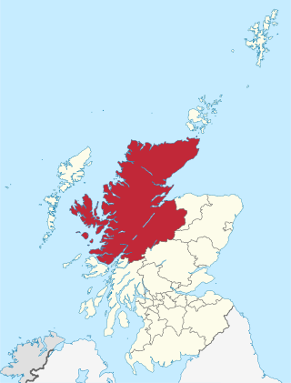
Highland is a council area in the Scottish Highlands and is the largest local government area in the United Kingdom. It was the 7th most populous council area in Scotland at the 2011 census. It shares borders with the council areas of Aberdeenshire, Argyll and Bute, Moray and Perth and Kinross. Their councils, and those of Angus and Stirling, also have areas of the Scottish Highlands within their administrative boundaries.
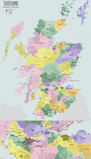
The shires of Scotland, or counties of Scotland, are historic subdivisions of Scotland established in the Middle Ages and used as administrative divisions until 1975. Originally established for judicial purposes, from the 17th century they started to be used for local administration purposes as well. The areas used for judicial functions (sheriffdoms) came to diverge from the shires, which ceased to be used for local government purposes after 1975 under the Local Government (Scotland) Act 1973.

Sutherland is a historic county, registration county and lieutenancy area in the Highlands of Scotland. Its county town is Dornoch. Sutherland borders Caithness and Moray Firth to the east, Ross-shire and Cromartyshire to the south and the Atlantic to the north and west. Like its southern neighbour Ross-shire, Sutherland has some of the most dramatic scenery in Europe, especially on its western fringe where the mountains meet the sea. These include high sea cliffs, and very old mountains composed of Precambrian and Cambrian rocks.

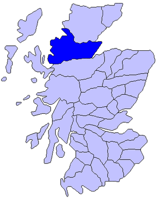
Ross and Cromarty, also referred to as Ross-shire and Cromartyshire, is a variously defined area in the Highlands and Islands of Scotland. There is a registration county and a lieutenancy area in current use, the latter of which is 8,019 square kilometres in extent. Historically there has also been a constituency of the Parliament of the United Kingdom, a local government county, a district of the Highland local government region and a management area of the Highland Council. The local government county is now divided between two local government areas: the Highland area and Na h-Eileanan Siar. Ross and Cromarty border Sutherland to the north and Inverness-shire to the south.
Ross is a region of Scotland. One of the provinces of Scotland from the 9th century, it gave its name to a later earldom and to the counties of Ross-shire and, later, Ross and Cromarty. The name Ross allegedly derives from a Gaelic word meaning "headland", perhaps a reference to the Black Isle. Another possible origin is the West Norse word for Orkney – Hrossey – meaning horse island; the area once belonged to the Norwegian earldom of Orkney. Ross is a historical comital region, perhaps predating the Mormaerdom of Ross. It is also a region used by the Kirk, with the Presbytery of Ross being part of the Synod of Ross, Sutherland and Caithness.

The North Caledonian Football Association is a senior football association operating throughout the Highlands and Islands of Scotland and is a recognised body of the Scottish Football Association (SFA) and as such has its senior football competitions officially registered with the SFA.

Caithness is a historic county, registration county and lieutenancy area of Scotland.
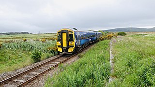
The Far North Line is a rural railway line entirely within the Highland area of Scotland, extending from Inverness to Thurso and Wick. As the name suggests, it is the northernmost railway in the United Kingdom. The line is entirely single-track, with only passing loops at some intermediate stations allowing trains to pass each other. In common with other railway lines in the Highlands and northern Lowlands, it is not electrified and all trains are diesel-powered.

Wester Ross is an area of the Northwest Highlands of Scotland in the council area of Highland. The area is loosely defined, and has never been used as a formal administrative region in its own right, but is generally regarded as lying to the west of the main watershed of Ross, thus forming the western half of the county of Ross and Cromarty. The southwesternmost part of Ross and Cromarty, Lochalsh, is not considered part of Wester Ross by the local tourist organisation, Visit Wester Ross, but is included within the definition used for the Wester Ross Biosphere Reserve.

Bonar Bridge is a village on the north bank of the Kyle of Sutherland to the west and the Dornoch Firth to the east in the Parish of Creich in the Highland council area of Scotland.
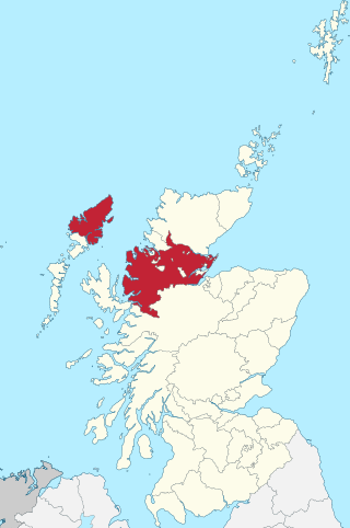
Ross-shire is a historic county in the Scottish Highlands. The county borders Sutherland to the north and Inverness-shire to the south, as well as having a complex border with Cromartyshire – a county consisting of numerous enclaves or exclaves scattered throughout Ross-shire's territory. Ross-shire includes most of Ross along with Lewis in the Outer Hebrides. Dingwall is the traditional county town. The area of Ross-shire is based on that of the historic province of Ross, but with the exclusion of the many enclaves that form Cromartyshire.
Ardgayard-GY ["high wind" - see below Further reading: MacGregor] is a small Scottish village on the south west shore of the Dornoch Firth, Sutherland and is 1 mile south from Bonar Bridge and lies at the entrance to Strathcarron, the valley of the River Carron and is at the mouth of the Kyle of Sutherland.
The Sutherland and Caithness Railway was a Scottish railway company that built a line from Helmsdale, the terminus of the Duke of Sutherland's Railway to Wick and Thurso in Caithness, giving the northern towns access to Inverness. It was driven through by the efforts of the 3rd Duke of Sutherland and the engineer Joseph Mitchell in the face of apathy from interests in Wick.

The River Oykel is a major river in northern Scotland that is famous for its salmon fishing. It rises on Ben More Assynt, a few miles from Ullapool on the west coast of Scotland, and drains into the North Sea via the Kyle of Sutherland. Traditionally it has marked the boundary between Ross to the south and Sutherland to the north.
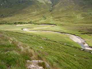
The River Carron is an east coast river in Sutherland, in the Highlands of Scotland.
The Sutherland Railway was a railway company authorised in 1865 to build a line from Bonar Bridge station to Brora, a distance of nearly 33 miles, in the north of Scotland. This was to be continuation of a route from Inverness to Bonar Bridge that had been built by the Inverness and Ross-shire Railway; ultimately the line was extended to Thurso.
The Duke of Sutherland's Railway was a railway in Sutherland, Scotland, built by the 3rd Duke of Sutherland.
The Inverness and Ross-shire Railway was a Scottish railway company formed in 1860 to build a line from Inverness to Invergordon. It opened in 1862 as far as Dingwall and in 1863 to Invergordon. It was extended to a Bonar Bridge station in 1864. It provided the basis for later extensions that eventually reached Thurso, forming the Far North Line. The Dingwall and Skye Railway branched off at Dingwall to reach the Kyle of Lochalsh.

Inverness-shire is a historic county, registration county and lieutenancy area of Scotland. Covering much of the Highlands and Outer Hebrides, it is Scotland's largest county, though one of the smallest in population, with 67,733 people or 1.34% of the Scottish population.
The Far North Line was built in several stages through sparsely populated and undulating terrain. Extending to 161 miles (259 km), it runs north from Inverness to Wick and Thurso in Caithness, and currently carries a regular passenger train service.

