Santiago de Cali, or Cali, is the capital of the Valle del Cauca department, and the most populous city in southwest Colombia, with an 2,227,642 residents according to the 2018 census. The city spans 560.3 km2 (216.3 sq mi) with 120.9 km2 (46.7 sq mi) of urban area, making Cali the second-largest city in the country by area and the third most populous. As the only major Colombian city with access to the Pacific Coast, Cali is the main urban and economic center in the south of the country, and has one of Colombia's fastest-growing economies. The city was founded on 25 July 1536 by the Spanish explorer Sebastián de Belalcázar.
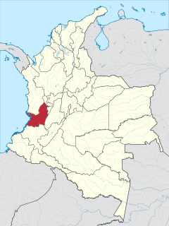
Valle del Cauca, or Cauca Valley, is a department of Colombia. It is on the western side of the country, abutting the Pacific Ocean. Its capital is Santiago de Cali. Such other cities as Buenaventura, Buga, Valle del Cauca, Cartago, Palmira, Valle del Cauca and Tuluá have great economical, political, social and cultural influence on the department's life. Valle del Cauca has the largest number of independent towns with over 100,000 inhabitants in the country, counting six within its borders. Buenaventura has the largest and busiest seaport in Colombia, moving about 8,500,000 tons of merchandise annually.
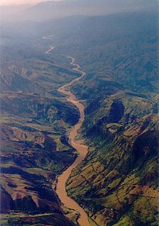
The Cauca River is a river in Colombia that lies between the Occidental and Central cordilleras. From its headwaters in southwestern Colombia near the city of Popayán, it joins the Magdalena River near Magangué in Bolívar Department, and the combined river eventually flows out into the Caribbean Sea. It has a length of 965 km (600 mi) to its junction with the Magdalena, for a total length of 1,350 km (840 mi). from origin to seamouth. The river is under the supervision of the Corporación Regional del Cauca and the Corporación Autonoma Regional del Valle del Cauca, and is navigable for 640 km (400 mi) above its junction with the Magdalena.

Alfonso Bonilla Aragón International Airport formerly known as Palmaseca International Airport is located between Palmira and Cali, the capital of Valle del Cauca Department, Colombia. It is Colombia's 4th busiest airport in passenger volume, with 5,600,000 people using the airport in 2016. It is the third largest airport in Colombia in terms of area and construction. The airport often serves as the alternate airport for Bogotá - El Dorado Int'l Airport and other Colombian airports.

Palmira is a city and municipality in southwestern Colombia in the Valle del Cauca Department, located about 27 kilometres (17 mi) east from Cali, the department's capital and main city in the South of Colombia. Palmira is the third largest city in the Valle del Cauca, behind Cali and Buenaventura.
Filandia is a town and municipality in the northern part of the department of Quindío, Colombia. It is located on the west side of Cordillera Central of the Andes mountain range running through central Colombia, 26 km north of the departmental capital Armenia. It is the northernmost of twelve municipalities that form Quindío, the second smallest department of Colombia. It houses a small community economically supported by agriculture and tourism. Although coffee is the major agricultural product, the municipality's diverse ecosystem makes it perfect for the production of numerous fruits and vegetables. The population is evenly split between the urban and rural areas, with an urban population in the town of Filandia itself of nearly 7000 inhabitants and a population of around 6500 in the rest of the municipality. Most of the population is classified as mestizo (63,2%) and the most common religion is Roman Catholic. The town's architecture, landscapes and the sociability of the locals makes Filandia one of the most beautiful and attractive towns in the department of Quindio and the nation. The town's best-known tourist attractions are its "mirador" with its extensive views over the Cauca River valley to the west and the Parque Nacional Natural los Nevados to the east, and the cafe in the main square where scenes from the popular Colombian telenovela Cafe, con aroma de mujer were filmed.

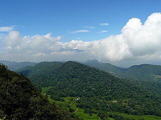
The Cordillera Occidental is the lowest in elevation of the three branches of the Colombian Andes. The average altitude is 2,000 m (6,600 ft) and the highest peak is Cerro Tatamá at 4,100 m (13,500 ft). The range extends from south to north dividing from the Colombian Massif in Nariño Department, passes north through Cauca, Valle del Cauca, Risaralda, Chocó, and Caldas Departments to the Paramillo Massif in Antioquia and Córdoba Departments. From this massif the range divides further to form the Serranías de Ayapel, San Jerónimo and Abibe. Only to recede into the Caribbean plain and the Sinú River valley.
Yumbo is a small, industrial city and municipality in western Colombia. It is located in the Valle del Cauca Department, just north of Cali. In 2019, it had a population of approximately 130,000 inhabitants.

Calima Lake is the largest artificial lake in Colombia and the American continent with an area of 70 km2. It is located in the municipality of Darién in the Valle del Cauca Department.

Buenaventura is a coastal seaport city on the department of Valle del Cauca, Colombia. Buenaventura is the main port of Colombia in the Pacific Ocean.
Patía is a colombian municipality located in Cauca department. The administrative centre of Patía is El Bordo.
El Cerrito is a town and municipality located in the Department of Valle del Cauca, Colombia. This is one of the 42 municipalities of the department.

The multicoloured tanager is a species of bird in the family Thraupidae. It is endemic to the mountains of Colombia, and as of 2010 has been categorized as vulnerable (VU) by the IUCN.

The Valle del Cauca Deputies hostage crisis refers to the kidnapping of 12 Deputies of the Valle del Cauca Department, Colombia, on April 12, 2002 by members of the Revolutionary Armed Forces of Colombia (FARC) to pressure a prisoner exchange between them and the government and to negotiate the demilitarization of the municipalities of Florida and Pradera to initiate peace dialogues.

The University of Valle, also called Univalle, is a public, departmental, coeducational, research university based primarily in the city of Cali, Valle del Cauca, Colombia. It is the largest higher education institution by student population in the southwest of the country, and the third in Colombia, with more than 30,000 students. The university was established by ordinance No. 12 of 1945, by the Departmental Assembly as the Industrial University of Valle del Cauca, under the leadership of Tulio Ramírez Rojas and Severo Reyes Gamboa.

Farallones de Cali is a cluster of mountains in the West Andes of Colombia. It is located west of the city of Cali and gives rise to many of the rivers that provide water and electricity to Cali. The PNN Farallones de Cali encompasses 150,000 ha (580 sq mi) in the mountains as well as much of the Pacific slope and is an area of very high biodiversity. The average temperature ranges from 25 °C (77 °F) in the tropical foothills to 5 °C (41 °F) in the páramo.

Yotoco is a town and municipality located in the Department of Valle del Cauca, Colombia.
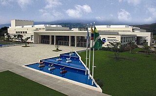
The Centro de Eventos Valle del Pacifico(Pacific Valley Events Center) is a convention center located in the city of Cali, Colombia on the highway between Yumbo and Cali.

Dapa is a small village and area of weekend homes in the Valle del Cauca Department of west central Colombia. It is located in the mountains about 15 kilometers northwest of the city of Cali. It is a township within the Municipality of Yumbo.
The area of Chicoral is located in the southernmost part of the township of Bitaco and within the municipality of La Cumbre in the Valle del Cauca Department of Colombia. It is home to the Hindú Tea Plantation, a major part of the Bitaco River Forest Reserve, and many small estates and farms. This region is only accessible by unpaved roads by way of La Cumbre from the north, the Cali-Buenaventura Road from the west and Dapa from the east through a forested pass at 2,100 m (6,900 ft).