La Fayette, Illinois

Last updated

La Fayette
Stark County Illinois Incorporated and Unincorporated areas La Fayette Highlighted.svg
Location of La Fayette in Stark County, Illinois.
Illinois in United States (US48).svg
Location of Illinois in the United States
Coordinates: 41°6′35″N89°58′25″W / 41.10972°N 89.97361°W / 41.10972; -89.97361
CountryUnited States
StateIllinois
County Stark
Area
[1]
  Total0.19 sq mi (0.49 km2)
  Land0.19 sq mi (0.49 km2)
  Water0.00 sq mi (0.00 km2)
Population
 (2020)
  Total160
  Density846.56/sq mi (327.15/km2)
Time zone UTC-6 (CST)
  Summer (DST) UTC-5 (CDT)
ZIP Code(s)
61449
Area code 309
FIPS code 17-40676
Wikimedia CommonsLa Fayette, Illinois

La Fayette (named after Gilbert du Motier, Marquis de Lafayette, pronounced locally "Lay - fay - et") is a village in Stark County, Illinois. It is located south of Kewanee off Route 78 on Route 17|IL-17 (Madison Street). The population was 223 at the 2010 census, down from 227 in 2000. It is part of the Peoria, Illinois Metropolitan Statistical Area. Once a prominent strip coal mine and farming village with; a general store, high school(until 1970), hotel, bank, grain elevator, train depot, and many other features and amenities. Once the coal mines shut down and railroad was removed in the early 1980s, it slowly became a low income and high poverty village with many people moving away and it eventually diminished to the hollow shell of what it once was.

Contents

Geography

La Fayette is located at 41°6′35″N89°58′25″W / 41.10972°N 89.97361°W / 41.10972; -89.97361 (41.109825, -89.973632). [2]

According to the 2010 census, La Fayette has a total area of 0.19 square miles (0.49 km2), all land. [3]

Demographics

Historical population
CensusPop.Note
1870 284
1880 265−6.7%
1890 250−5.7%
1900 28313.2%
1910 2871.4%
1920 258−10.1%
1930 253−1.9%
1940 29516.6%
1950 3012.0%
1960 269−10.6%
1970 268−0.4%
1980 2814.9%
1990 231−17.8%
2000 227−1.7%
2010 223−1.8%
2020 160−28.3%
U.S. Decennial Census [4]

As of the census [5] of 2000, there were 227 people, 91 households, and 63 families residing in the village. The population density was 1,235.2 inhabitants per square mile (476.9/km2). There were 93 housing units at an average density of 506.0 per square mile (195.4/km2). The racial makeup of the village was 96.48% White, 0.44% Asian, 1.76% from other races, and 1.32% from two or more races. Hispanic or Latino of any race were 1.76% of the population.

There were 91 households, out of which 30.8% had children under the age of 18 living with them, 59.3% were married couples living together, 6.6% had a female householder with no husband present, and 29.7% were non-families. 24.2% of all households were made up of individuals, and 15.4% had someone living alone who was 65 years of age or older. The average household size was 2.49 and the average family size was 2.98.

In the village, the population was spread out, with 27.3% under the age of 18, 5.3% from 18 to 24, 22.9% from 25 to 44, 23.3% from 45 to 64, and 21.1% who were 65 years of age or older. The median age was 40 years. For every 100 females, there were 83.1 males. For every 100 females age 18 and over, there were 83.3 males.

The median income for a household in the village was $26,563, and the median income for a family was $28,125. Males had a median income of $28,125 versus $20,893 for females. The per capita income for the village was $15,002. About 9.0% of families and 13.2% of the population were below the poverty line, including 28.3% of those under the age of eighteen and 13.0% of those 65 or over.

Related Research Articles

<span class="mw-page-title-main">Napakiak, Alaska</span> City in Alaska, United States

Napakiak is a city in Bethel Census Area, Alaska, United States. At the 2010 census the population was 354, up one resident from 353 since 2000.

<span class="mw-page-title-main">Golden, Illinois</span> Village in Illinois, United States

Golden is a village in Adams County, Illinois, United States. The population was 648 at the 2010 census. It is part of the Quincy, IL–MO Micropolitan Statistical Area.

<span class="mw-page-title-main">Bingham, Illinois</span> Village in Illinois, United States

Bingham is a village in Fayette County, Illinois, United States. The population was 60 at the 2020 census.

<span class="mw-page-title-main">Nora, Illinois</span> Village in Illinois, United States

Nora is a village in Jo Daviess County, Illinois, United States. In 2020, the population was 107, down from 121 according to the 2010 census, which was up from 118 in 2000.

<span class="mw-page-title-main">Hillcrest, Illinois</span> Village in Illinois, United States

Hillcrest is a village located in Ogle County, Illinois, United States. The 2010 census lists its population at 1,326, up from 1,158 in 2000.

<span class="mw-page-title-main">Tilden, Illinois</span> Village in Illinois, United States

Tilden is a village in Randolph County, Illinois, United States. The population was 934 at the 2010 census.

<span class="mw-page-title-main">Spaulding, Illinois</span> Village in Illinois, United States

Spaulding is a village in Sangamon County, Illinois, United States. The population was 873 at the 2010 census. It is part of the Springfield, Illinois Metropolitan Statistical Area. Spaulding is in the Riverton School District #14.

<span class="mw-page-title-main">Fairbank, Iowa</span> City in Iowa, United States

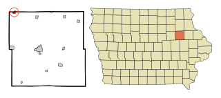
Fairbank is a city in Buchanan and Fayette counties in the U.S. state of Iowa. The population was 1,111 at the time of the 2020 census.

<span class="mw-page-title-main">Grayson, Louisiana</span> Village in Louisiana, United States

Grayson is a village in Caldwell Parish, Louisiana, United States. The population was 532 at the 2010 census.

<span class="mw-page-title-main">Easton, Minnesota</span> City in Minnesota, United States

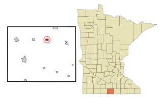
Easton is a city in Faribault County, Minnesota, United States. The population was 199 at the 2010 census.

<span class="mw-page-title-main">Rives, Missouri</span> Village in Missouri, United States

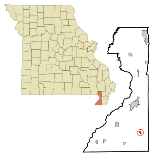
Rives is a town in Dunklin County, Missouri, United States. The population was 63 at the 2010 census.

<span class="mw-page-title-main">Shoal Creek Estates, Missouri</span> Village in Missouri, United States

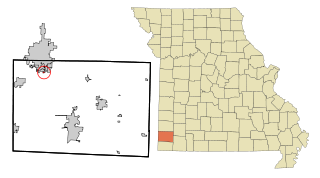
Shoal Creek Estates is a village in Newton County, Missouri, United States. The population was 76 at the 2010 census. It is part of the Joplin, Missouri Metropolitan Statistical Area.

<span class="mw-page-title-main">Staplehurst, Nebraska</span> Village in Seward County, Nebraska, United States

Staplehurst is a village in Seward County, Nebraska, United States. It is part of the Lincoln, Nebraska Metropolitan Statistical Area. The population was 242 at the 2010 census.

<span class="mw-page-title-main">Rock Creek, Ohio</span> Village in Ohio, United States

Rock Creek is a village in Ashtabula County, Ohio, United States. The population was 667 at the 2020 census. It is part of the Ashtabula micropolitan area, 45 miles (72 km) northeast of Cleveland.

<span class="mw-page-title-main">Cuyahoga Heights, Ohio</span> Village in Ohio, United States

Cuyahoga Heights is a village in Cuyahoga County, Ohio, United States. The population was 573 at the 2020 census.

<span class="mw-page-title-main">Jeffersonville, Ohio</span> Village in Ohio, United States

Jeffersonville is a village in Fayette County, Ohio, United States. The population was 1,258 at the 2020 census.

<span class="mw-page-title-main">Harbor View, Ohio</span> Village in Ohio, United States

Harbor View is a village in Lucas County, Ohio, United States. The population was 89 at the 2020 census.

<span class="mw-page-title-main">Rosemount, Ohio</span> Census-designated place in Ohio, United States

Rosemount is a census-designated place (CDP) in Clay Township, Scioto County, Ohio, United States. The population was 2,117 at the 2020 census.

<span class="mw-page-title-main">Iola, Pennsylvania</span> Census-designated place in Pennsylvania, United States

Iola is a census-designated place in Columbia County, Pennsylvania, United States. It is part of Northeastern Pennsylvania. The population was 144 at the 2010 census. It is part of the Bloomsburg-Berwick micropolitan area.

<span class="mw-page-title-main">Smithers, West Virginia</span> Place in West Virginia, United States

Smithers is a city in Fayette and Kanawha counties in the U.S. state of West Virginia. Located along the Kanawha River, it lies almost entirely in Fayette County. The population was 751 at the 2020 census. The city most likely takes its name from Smithers Creek. The small river city is noted for having a rich cultural history related to both its coal mining and Italian-American heritages.

References

  1. "2020 U.S. Gazetteer Files". United States Census Bureau. Retrieved March 15, 2022.
  2. "US Gazetteer files: 2010, 2000, and 1990". United States Census Bureau. February 12, 2011. Retrieved April 23, 2011.
  3. "G001 - Geographic Identifiers - 2010 Census Summary File 1". United States Census Bureau. Archived from the original on February 13, 2020. Retrieved August 4, 2015.
  4. "Census of Population and Housing". Census.gov. Retrieved June 4, 2015.
  5. "U.S. Census website". United States Census Bureau . Retrieved January 31, 2008.