La Harpe, Illinois

Last updated
La Harpe, Illinois
La Harpe Station - August 2016.jpg
The former Toledo, Peoria and Western Railroad tracks through La Harpe
Hancock County Illinois Incorporated and Unincorporated areas La Harpe Highlighted.svg
Location of La Harpe in Hancock County, Illinois.
Illinois in United States (US48).svg
Location of Illinois in the United States
Coordinates: 40°34′59″N90°58′8″W / 40.58306°N 90.96889°W / 40.58306; -90.96889 Coordinates: 40°34′59″N90°58′8″W / 40.58306°N 90.96889°W / 40.58306; -90.96889
CountryUnited States
StateIllinois
County Hancock
Area
[1]
  Total1.36 sq mi (3.53 km2)
  Land1.36 sq mi (3.53 km2)
  Water0.00 sq mi (0.00 km2)
Elevation
[2]
696 ft (212 m)
Population
 (2020)
  Total1,175
  Density861.44/sq mi (332.72/km2)
Time zone UTC-6 (CST)
  Summer (DST) UTC-5 (CDT)
ZIP Code(s)
61450
Area code 217
FIPS code 17-40832
GNIS feature ID2395566 [2]
Wikimedia CommonsLa Harpe, Illinois
Website cityoflaharpe.com

La Harpe is a town in Hancock County, Illinois, United States. The population was 1,235 at the 2010 census, [3] down from 1,385 at the 2000 census.

Contents

History

During the 18th century, French explorers headed by Bernard de la Harpe were forced to spend the winter just north of the present city of La Harpe. About 1896, four stone tablets dated June 15, 1715, and inscribed in French were reportedly found a few miles east of the old fortification built by the explorers. Stones were translated locally by the only French family in town as follows: "We are surrounded by indians and have no hope for survival unless help soon arrives." Said stone tablets were reported to be sent to the Smithsonian for authentication, and were ruled a hoax. Their whereabouts are currently unknown.

Soon after 1830, landowners in the area began to develop a town which they called "Franklin". In 1836, they applied for a post office and were informed another town in Illinois was already named Franklin. The first postmaster, Louis Rice Chaffin, suggested the name be registered as "La Harpe", for the Frenchman who spent the winter over 100 years earlier. The City of La Harpe was granted a charter by the Illinois legislature in 1859. The charter was amended in 1861 to change the size of the town, and the boundaries have changed through the years. Today the city has 22 streets and avenues.

The Toledo, Peoria and Western depot in La Harpe, June 1963 Toledo, Peoria & Western depot at La Harpe, IL.jpg
The Toledo, Peoria and Western depot in La Harpe, June 1963

In 1867, the TP&W railroad line was completed through the town. In 1888, the city council bought the first fire engine, but a fire in October 1893 still destroyed nearly all the businesses in one block of Main Street. City Hall was built in 1894. The election of 1895 was the first election in which the women of La Harpe were allowed to vote on the issue of liquor licenses. (The women had a separate ballot box.) The La Harpe Carnegie Public Library was built in 1905, with local support and a donation from Andrew Carnegie. Today it is listed on the National Register of Historic Sites. The City Park was donated by Marvin Tyron, one of the town's founders, as a public square.

In 1986, La Harpe celebrated 150 years of history. During that year, a sesquicentennial history entitled La Harpe, Illinois, 1836-1986 was published.

Each summer the town used to celebrate their Summerfest on the town square. The annual Fred Gibb Car Show is held in August. Gibb's claim to fame was as the sponsor of the original ZL-1 COPO Camaros and Novas during the pony car era of the early 1970s. Gibb's name has since been omitted from the car show.

Today, many of the surviving buildings in La Harpe's business districts, including the City Hall, are on the National Register of Historic Places. La Harpe had the only four-story building in Hancock County. The park district includes a community clubhouse, swimming pool, the LaMoine Valley golf course, and a complex of lighted ball fields. The city park has a lighted shelter house and stage.

Geography

La Harpe is located in northeastern Hancock County at 40°34′59″N90°58′08″W / 40.582925°N 90.968770°W / 40.582925; -90.968770 , [4] south of the South Branch La Moine River. Illinois Route 9 passes through the city as its Main Street, leading east 25 miles (40 km) to Bushnell and west 13 miles (21 km) to Dallas City on the Mississippi River. Illinois Route 94 intersects IL 9 at the western edge of the city, and leads north 15 miles (24 km) to Stronghurst.

According to the 2010 census, La Harpe has a total area of 1.36 square miles (3.52 km2), all land. [5]

Climate

Climate data for La Harpe, Illinois (1991–2020 normals, extremes 1895–present)
MonthJanFebMarAprMayJunJulAugSepOctNovDecYear
Record high °F (°C)70
(21)
79
(26)
88
(31)
94
(34)
105
(41)
108
(42)
110
(43)
113
(45)
103
(39)
96
(36)
83
(28)
73
(23)
113
(45)
Average high °F (°C)31.8
(−0.1)
36.6
(2.6)
49.3
(9.6)
61.7
(16.5)
72.3
(22.4)
81.1
(27.3)
84.6
(29.2)
83.0
(28.3)
76.7
(24.8)
64.2
(17.9)
49.3
(9.6)
37.0
(2.8)
60.6
(15.9)
Daily mean °F (°C)23.3
(−4.8)
27.8
(−2.3)
39.3
(4.1)
50.9
(10.5)
62.0
(16.7)
71.2
(21.8)
74.6
(23.7)
72.8
(22.7)
65.3
(18.5)
53.2
(11.8)
39.9
(4.4)
28.9
(−1.7)
50.8
(10.4)
Average low °F (°C)14.9
(−9.5)
19.0
(−7.2)
29.3
(−1.5)
40.0
(4.4)
51.7
(10.9)
61.3
(16.3)
64.7
(18.2)
62.6
(17.0)
54.0
(12.2)
42.2
(5.7)
30.5
(−0.8)
20.8
(−6.2)
40.9
(4.9)
Record low °F (°C)−23
(−31)
−30
(−34)
−13
(−25)
5
(−15)
26
(−3)
37
(3)
42
(6)
36
(2)
23
(−5)
1
(−17)
−3
(−19)
−26
(−32)
−30
(−34)
Average precipitation inches (mm)1.60
(41)
1.83
(46)
2.42
(61)
3.92
(100)
5.22
(133)
4.94
(125)
4.23
(107)
3.42
(87)
3.83
(97)
3.10
(79)
2.54
(65)
2.05
(52)
39.10
(993)
Average precipitation days (≥ 0.01 in)5.96.06.59.310.79.18.47.46.57.46.46.189.7
Source: NOAA [6] [7]

Demographics

Historical population
CensusPop.
1880 958
1890 1,11316.2%
1900 1,59142.9%
1910 1,349−15.2%
1920 1,323−1.9%
1930 1,175−11.2%
1940 1,32212.5%
1950 1,295−2.0%
1960 1,3222.1%
1970 1,240−6.2%
1980 1,47118.6%
1990 1,407−4.4%
2000 1,385−1.6%
2010 1,235−10.8%
2020 1,175−4.9%
U.S. Decennial Census [8]

As of the census [9] of 2000, there were 1,385 people, 561 households, and 383 families residing in the city. The population density was 1,021.8 inhabitants per square mile (394.5/km2). There were 604 housing units at an average density of 445.6 per square mile (172.0/km2). The racial makeup of the city was 99.78% White, 0.07% from other races, and 0.14% from two or more races. Hispanic or Latino of any race were 0.14% of the population.

There were 561 households, out of which 31.2% had children under the age of 18 living with them, 57.0% were married couples living together, 9.4% had a female householder with no husband present, and 31.6% were non-families. 29.1% of all households were made up of individuals, and 16.0% had someone living alone who was 65 years of age or older. The average household size was 2.39 and the average family size was 2.93.

In the city, the population was spread out, with 24.0% under the age of 18, 6.5% from 18 to 24, 24.4% from 25 to 44, 23.5% from 45 to 64, and 21.7% who were 65 years of age or older. The median age was 41 years. For every 100 females, there were 85.2 males. For every 100 females age 18 and over, there were 77.3 males.

The median income for a household in the city was $32,589, and the median income for a family was $37,708. Males had a median income of $31,250 versus $20,400 for females. The per capita income for the city was $15,586. About 4.6% of families and 7.4% of the population were below the poverty line, including 8.9% of those under age 18 and 6.3% of those age 65 or over.

Schools

Illini West High School

In August 2007, La Harpe High School, as well as Dallas City and Carthage High Schools, were deactivated through the first school convergence to be approved by voters in the state of Illinois, with much regret. Former La Harpe students are now attending the newly formed Illini West High School in Carthage, Illinois.

La Harpe Grade School/Jr. High

The La Harpe Community School District #347 was formed with the dissolution of District #335. The former High School facility was renovated extensively.

La Harpe Elementary was recently[ when? ] named an Illinois Spotlight School. A Spotlight School is a high poverty school where academic performance is closing the "achievement gap". [10]

La Harpe High School

In 1996, the Northwestern-La Harpe Thunder football team was the first athletic team with La Harpe High School students to ever participate in the IHSA State Finals. They were defeated 35-28 by the Chenoa Redbirds. In 2000, the team once again made it to the IHSA State Finals and were defeated by the Carthage Blueboys 14–0.

In 1839, a log cabin was built to be used as a blacksmith shop. After a few years it became the first school house in La Harpe. The log cabin served as a school house until 1844, when it was sold and became a blacksmith shop again. The next school building was a brick building that had an enrollment of 98 students. This building served as a public school until the academy was built in 1857. The Academy was located on the present site of the elementary school building. A new building was built in 1898 for a larger student body. This building served as the high school and elementary school until it was destroyed by fire in 1927. A new structure was built in 1929. This building was in use until 2012 when it was dismantled in anticipation of grant funding for a new school from the State of Illinois, which never materialized. The school became La Harpe Community School District on April 20, 1942. In 1958, the current high school building was built. On May 2, 1961, the former La Harpe Community School District #335 was formed from the communities of Fountain Green, Terre Haute, La Harpe, and Durham. On May 27, 2007, the high school hosted its final graduation.

Park District

Notable people

Related Research Articles

<span class="mw-page-title-main">Green County, Kentucky</span> County in Kentucky, United States

Green County is a county located in the U.S. state of Kentucky. Its county seat is Greensburg. Green was a prohibition or dry county until 2015.

<span class="mw-page-title-main">Henderson County, Illinois</span> County in Illinois, United States

Henderson County is a county located in the U.S. state of Illinois. According to the 2010 United States Census, it has a population of 7,331. Its county seat is Oquawka.

<span class="mw-page-title-main">Hancock County, Illinois</span> County in Illinois, United States

Hancock County is a county in the U.S. state of Illinois. According to the 2020 census, it has a population of 17,620. Its county seat is Carthage, and its largest city is Hamilton. The county is made up of rural towns with many farmers.

<span class="mw-page-title-main">Glendale Heights, Illinois</span> Village in Illinois, United States

Glendale Heights is a village in DuPage County, Illinois, United States. Per the 2020 census, the population was 33,176.

<span class="mw-page-title-main">Paxton, Illinois</span> City in Illinois, United States

Paxton is a city in Ford County, Illinois, United States. The population was 4,473 at the 2010 census. It is the county seat of Ford County.

<span class="mw-page-title-main">Seneca, Illinois</span> Village in Illinois, United States

Seneca is a village in LaSalle and Grundy counties in the U.S. state of Illinois. The population was 2,353 at the 2020 census, down from 2,371 at the 2010 census.

<span class="mw-page-title-main">Carthage, Illinois</span> City in Illinois, United States

Carthage is a city and the county seat of Hancock County, Illinois, United States. The population was 2,490 as of the 2020 census, Carthage is best known for being the site of the 1844 death of Joseph Smith, founder of the Latter Day Saint movement.

<span class="mw-page-title-main">Dallas City, Illinois</span> City in Illinois, United States

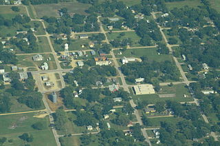
Dallas City is a city in Hancock and Henderson counties in the U.S. state of Illinois. The population in 2020 stands at an estimate of 805, a decline from the 2010 census of 945, which was a decline from 1,055 in 2000.

<span class="mw-page-title-main">Hamilton, Illinois</span> Place in Illinois, United States

Hamilton is a city in Hancock County, Illinois, United States. The population was 2,951 at the 2010 census, a decline from 3,029 in 2000. The city is located directly across the Mississippi River from Keokuk, Iowa. Hamilton is the largest city in Hancock County.

<span class="mw-page-title-main">Nauvoo, Illinois</span> City in Illinois, United States

Nauvoo is a small city in Hancock County, Illinois, United States, on the Mississippi River near Fort Madison, Iowa. The population of Nauvoo was 950 at the 2020 census. Nauvoo attracts visitors for its historic importance and its religious significance to members of several groups: The Church of Jesus Christ of Latter-day Saints; the Community of Christ, formerly the Reorganized Church of Jesus Christ of Latter Day Saints (RLDS); other groups stemming from the Latter Day Saint movement; and the Icarians. The city and its immediate surrounding area are listed on the National Register of Historic Places as the Nauvoo Historic District.

<span class="mw-page-title-main">Warsaw, Illinois</span> City in Illinois, United States

Warsaw is a city in Hancock County, Illinois, United States. The population was 1,607 at the 2010 census, a decline from 1,793 in 2000. The city is notable for its historic downtown and the Warsaw Brewery, which operated for more than 100 years beginning in 1861 and, after renovation, reopened as a bar, restaurant and microbrewery in 2006.

<span class="mw-page-title-main">Newton, Illinois</span> City in Illinois, United States

Newton is a city in and the county seat of Jasper County, Illinois, United States. The population was 2,849 at the 2010 census, down from 3,069 at the 2000 census. Newton is home to a large coal-fired power plant operated by Illinois Power Generating Co and is close to Newton Lake State Fish and Wildlife Area and Sam Parr State Fish and Wildlife Area.

<span class="mw-page-title-main">Millington, Illinois</span> Village in Illinois, United States

Millington is a village in Kendall and LaSalle counties in the U.S. state of Illinois. The population was 617 at the 2020 census down from 665 at the 2010 census,.

<span class="mw-page-title-main">Yorkville, Illinois</span> City in Illinois, United States

Yorkville is a city and county seat of Kendall County, Illinois, United States. The population was 21,533 at the 2020 census.

<span class="mw-page-title-main">Corwith, Iowa</span> City in Iowa, United States

Corwith is a city in Hancock County, Iowa, United States. The population was 266 at the time of the 2020 census.

<span class="mw-page-title-main">La Harpe, Kansas</span> City in Allen County, Kansas

La Harpe is a city in Allen County, Kansas, United States. As of the 2020 census, the population of the city was 480.

<span class="mw-page-title-main">Hancock, Minnesota</span> City in Minnesota, United States

Hancock is a city in Stevens County, Minnesota, United States. The population was 863 at the 2020 census.

<span class="mw-page-title-main">Durham Township, Hancock County, Illinois</span> Township in Illinois, United States

Durham Township is one of twenty-four townships in Hancock County, Illinois, USA. As of the 2010 census, its population was 278 and it contained 129 housing units.

<span class="mw-page-title-main">Illini West High School</span> High school in Carthage, Illinois

Illini West High School (IWHS) is a public high school in Carthage, Illinois, United States. IWHS serves a mostly rural area that includes most of northeastern Hancock County and extends into parts of Henderson and McDonough Counties, covering the cities of Carthage, Dallas City, and La Harpe, and the village of Ferris. The campus is located 25 miles (40 km) west of Macomb, Illinois, and has a student body of 332 students in grades 9–12 as of the 2017–18 school year. IWHS was established in 2007 as a consolidation of Carthage, Dallas City, and La Harpe High Schools and is housed at the former Carthage High School. The school is administered by the Illini West Community Unit School District 307, while the elementary and middle feeder schools in each of the communities that consolidated are administered by the Carthage Elementary School District 317, Dallas Elementary School District 327, and La Harpe Community School District 347.

<span class="mw-page-title-main">Garner, Iowa</span> City in Iowa, United States

Garner is a city in and the county seat of Hancock County, Iowa, United States. The population was 3,065 in the 2020 census, an increase from 2,922 in 2000.

References

  1. "2020 U.S. Gazetteer Files". United States Census Bureau. Retrieved March 15, 2022.
  2. 1 2 U.S. Geological Survey Geographic Names Information System: La Harpe, Illinois
  3. "Geographic Identifiers: 2010 Demographic Profile Data (G001): La Harpe city, Illinois". American Factfinder. U.S. Census Bureau. Retrieved June 9, 2017.[ dead link ]
  4. "US Gazetteer files: 2010, 2000, and 1990". United States Census Bureau. 2011-02-12. Retrieved 2011-04-23.
  5. "G001 - Geographic Identifiers - 2010 Census Summary File 1". United States Census Bureau. Archived from the original on 2020-02-13. Retrieved 2015-12-27.
  6. "NowData – NOAA Online Weather Data". National Oceanic and Atmospheric Administration. Retrieved July 11, 2021.
  7. "Station: La Harpe, IL". U.S. Climate Normals 2020: U.S. Monthly Climate Normals (1991-2020). National Oceanic and Atmospheric Administration. Retrieved July 11, 2021.
  8. "Census of Population and Housing". Census.gov. Retrieved June 4, 2015.
  9. "U.S. Census website". United States Census Bureau . Retrieved 2008-01-31.
  10. "La Harpe Community District 347 - Illinois Spotlight School". www.laharpeeagles.org. Archived from the original on 2016-03-04.
  11. Ham, Eldon L. (2011). Broadcasting Baseball: A History of the National Pastime on Radio and Television. McFarland. p. 26. ISBN   978-0-786-48635-9 . Retrieved June 21, 2016.
  12. Dunning, John. On the Air: The Encyclopedia of Old-Time Radio. Oxford University Press, 1998; ISBN   0-19-507678-8