La Mesa Watershed Reservation

Last updated

La Mesa Watershed Reservation
Novaliches Watershed
La Mesa Watershed satellite.jpg
The La Mesa Watershed Reservation as viewed from space. 2016
Metro Manila location map.svg
Red pog.svg
Location in Metro Manila
LocationPrimarily in Quezon City
and part of Caloocan and Rizal
Coordinates 14°44′37″N121°6′3″E / 14.74361°N 121.10083°E / 14.74361; 121.10083
Area2,659 hectares (6,570 acres)
EstablishedJuly 25, 2007;15 years ago (2007-07-25)
Visitors300,000(in 2015)
Governing body Department of Environment and Natural Resources
Metropolitan Waterworks and Sewerage System

The La Mesa Watershed Reservation is a protected area that preserves the only major watershed in Metro Manila, Philippines. Also known as the Novaliches Watershed, it contains the last remaining rainforest of its size in Metro Manila surrounding the La Mesa Dam and Reservoir, the primary source of potable drinking water for 12 million residents in the Manila metropolitan area. [1] The area is under the joint administration, supervision and control of the Department of Environment and Natural Resources and the Metropolitan Waterworks and Sewerage System. It was established in 2007 through Proclamation No. 1336 issued by President Gloria Arroyo. [2]

Contents

Geography

The La Mesa Dam and Reservoir as seen from Mount Maarat in the Sierra Madre range in San Mateo Metro Manila view - Fairview, Novaliches, La Mesa Dam, Payatas (Mount Maarat, San Mateo, Rizal)(2017-11-19).jpg
The La Mesa Dam and Reservoir as seen from Mount Maarat in the Sierra Madre range in San Mateo

The La Mesa Watershed encompasses an area of 2,659 hectares (6,570 acres) in the northern fringes of Quezon City, Caloocan and Rodriguez, Rizal. It is situated on a flat-topped hill or mesa at the foot of the southern Sierra Madre mountain range west of the Marikina Valley. It is about 9 kilometres (5.6 mi) north from the center of Quezon City in Diliman, and some 20 kilometres (12 mi) northeast from the center of Manila in Rizal Park.

The highest elevation in Quezon City is in the watershed's northern tip at 250 metres (820 ft) above sea level. [3] It centers on the 700-hectare (1,700-acre) La Mesa Dam and Reservoir in Novaliches, an artificial lake which was created in 1929 as part of Manila's Ipo–Novaliches–San Juan water system under the American colonial government. [4] The surrounding 2,000-hectare (4,900-acre) forest contains more than 50 kilometres (31 mi) of nature trails and serves as the lungs of Metro Manila, providing it with clean air. [5] It also contains the 33-hectare (82-acre) ecological park known as the La Mesa Eco Park. This park located at the southern edges of the watershed in East Fairview is administered by the Quezon City Parks Development and Administration Department and was opened in 2003. [6]

The Tullahan River which passes through Malabon and Navotas starts from the La Mesa Watershed Reservation. It flows until Manila Bay. [7]

Million Trees Nursery and Eco Learning Center - Eddie's Barn Million Trees Nursery and Eco Learning Center Eddie's Barn 14.jpg
Million Trees Nursery and Eco Learning Center - Eddie's Barn

Tourism

In 2015, it was reported that 300 thousand people visit the La Mesa Watershed Reservation annually according to park officials. The protected area also has 50 kilometers (31 mi) of nature trails. [8]

Biodiversity

A male spotted wood kingfisher at the La Mesa Watershed Reservation Actenoides lindsayi -Philippines -male-8.jpg
A male spotted wood kingfisher at the La Mesa Watershed Reservation

The La Mesa Watershed comprises a variety of ecosystems that is home to many indigenous and endemic species of flora and fauna. Approximately 1,800 hectares (4,400 acres) are under forest cover and 300 hectares (740 acres) are open areas, pastures and areas under cultivation. Several portions of the La Mesa reservoir are shallow with exposed mudflats, swampforest, reed and other swamp vegetation. Its forest serves as an important breeding area for a variety of wildlife species and birds such as the little heron, black-crowned night heron, osprey, Japanese sparrowhawk, plain bush-hen, common moorhen, Eurasian coot, Philippine coucal, Philippine nightjar, island swiftlet, spotted wood kingfisher, common kingfisher, white-collared kingfisher, Philippine pygmy woodpecker, barn swallow, pied triller, ashy minivet, Philippine bulbul, black-naped oriole, Oriental magpie robin, Arctic warbler, grey-streaked flycatcher, pied fantail, yellow-bellied whistler, grey wagtail, brown shrike, olive-backed sunbird, and lowland white-eye. [9]

The most common tree species found in the reservation are Malay beechwood, earleaf acacia, acacia mangium, narra, mahogany, teak, ipil-ipil, alibangbang and bangkal. [10]

Threats

Threats to the watershed's biodiversity come from land conversion and deforestation from illegal harvesting of forest products. [11] In 2014, the La Mesa park ranger recorded a total of 25 informal settler families living within the reservation who engage in slash-and-burn cultivation or kaingin. A portion of the watershed was also reportedly sold as housing for employees of the Metropolitan Waterworks and Sewerage System which was flagged by the Commission on Audit. Former Environment Secretary Gina Lopez cancelled the environmental compliance certificate for the sale in December 2016. [11]

The Manila Seedling Bank conducted a five-year reforestation program at the watershed from 1978 to 1983. [12] In a 2013 vulnerability assessment by scientist Cristino Tiburan, the La Mesa Watershed Reservation was found to be prone to erosion and landslide. [11]

See also

Related Research Articles

<span class="mw-page-title-main">Metro Manila</span> Metropolitan area and region of the Philippines

Metropolitan Manila, officially the National Capital Region, is the seat of government and one of three defined metropolitan areas in the Philippines. It is composed of 16 highly urbanized cities: the city of Manila, Quezon City, Caloocan, Las Piñas, Makati, Malabon, Mandaluyong, Marikina, Muntinlupa, Navotas, Parañaque, Pasay, Pasig, San Juan, Taguig, and Valenzuela, as well as the municipality of Pateros. The region encompasses an area of 619.57 square kilometers (239.22 sq mi) and a population of 13,484,462 as of 2020. It is the second most populous and the most densely populated region of the Philippines. It is also the 9th most populous metropolitan area in Asia and the 5th most populous urban area in the world.

<span class="mw-page-title-main">Rizal (province)</span> Province in Calabarzon, Philippines

Rizal, officially the Province of Rizal, is a province in the Philippines located in the Calabarzon region in Luzon. Its capital is the city of Antipolo. It is about 16 kilometres (9.9 mi) east of Manila. The province is named after José Rizal, one of the main national heroes of the Philippines. It is bordered by Metro Manila to the west, Bulacan to the north, Quezon to the east and Laguna to the southeast. The province also lies on the northern shores of Laguna de Bay, the largest lake in the country. Rizal is a mountainous province perched on the western slopes of the southern portion of the Sierra Madre mountain range.

<span class="mw-page-title-main">Quezon City</span> Highly urbanized city in Metro Manila, Philippines

Quezon City, also known as the City of Quezon and Q.C., is the most populous city in the Philippines. According to the 2020 census, it has a population of 2,960,048 people. It was founded on October 12, 1939, and was named after Manuel L. Quezon, the second president of the Philippines.

<span class="mw-page-title-main">Caloocan</span> Highly urbanized city in Metro Manila, Philippines

Caloocan, officially the City of Caloocan, is a 1st class highly urbanized city in Metro Manila, Philippines. According to the 2020 census, it has a population of 1,661,584 people making it the fourth-most populous city in the Philippines.

<span class="mw-page-title-main">Manila Water</span>

Manila Water Company, Inc. has the exclusive right to provide water and used water (wastewater) services to over six million people in the East Zone of Metro Manila. It is a subsidiary of the country's oldest conglomerate, Ayala Corporation.

<span class="mw-page-title-main">Novaliches</span> Place in National Capital Region, Philippines

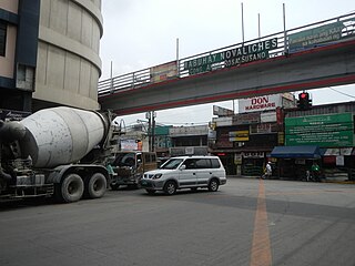
Novaliches is a place that forms the northern areas of Quezon City, and encompasses the whole area of North Caloocan.

This is a list of current and former national capital cities in the Philippines, which includes during the time of the Spanish colonization, the First Philippine Republic, the Commonwealth of the Philippines, the Second Republic of the Philippines, the Third Republic of the Philippines, the Fourth Republic of the Philippines and the current Fifth Republic of the Philippines.

<span class="mw-page-title-main">La Mesa Dam and Reservoir</span> Dam in Quezon City, Philippines

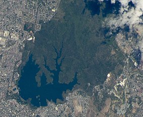
The La Mesa Dam and Reservoir is an earth dam in Quezon City, Philippines. Its reservoir can hold up to 50.5 million cubic meters, occupying an area of 27 square kilometers (10 sq mi). It is part of the Angat-Ipo-La Mesa water system, which supplies most of the water supply of Metro Manila.

<span class="mw-page-title-main">Angat Dam</span> Dam in Bulacan, Philippines

Angat Dam is a concrete water reservoir embankment hydroelectric dam that supplies Metro Manila and nearby provinces with water. It was a part of the Angat-Ipo-La Mesa water system. The reservoir supplies about 90 percent of raw water requirements for Metro Manila through the facilities of the Metropolitan Waterworks and Sewerage System and it irrigates about 28,000 hectares of farmland in the provinces of Bulacan and Pampanga.

Several bulk water supply projects on the upper portion of the Kaliwa River Watershed have been proposed by the Philippine Government since the 1970s, with the intent of relieving Metro Manila of its overdependence on the water supplied by Angat Dam. Most of these have focused on a particular site in Barangay Laiban in Tanay, Rizal, on the upper portion of the Kaliwa River Watershed to which the Laiban Dam belongs, and the projects have thus often been referred to as Laiban dam or Kaliwa dam, although multiple projects have been referred to using either name.

Metro Manila, the capital region of the Philippines, is a large metropolitan area that has several levels of subdivisions. Administratively, the region is divided into seventeen primary local government units with their own separate elected mayors and councils who are coordinated by the Metropolitan Manila Development Authority, a national government agency headed by a chairperson directly appointed by the Philippine president. The cities and municipality that form the region's local government units are further divided into several barangays or villages which are headed by an elected barangay captain and barangay council.

<span class="mw-page-title-main">Balara Filters Park</span>

The Balara Filters Park is a 60-hectare (150-acre) park located in the Diliman village of Pansol in Quezon City, Metro Manila, Philippines, adjacent to the University of the Philippines Diliman main campus. It is bounded by Katipunan Avenue on the west, Capitol Hills Golf and Country Club on the north, and the upscale, gated village of La Vista along its south and east.

<span class="mw-page-title-main">Outline of Metro Manila</span> Overview of and topical guide to Metro Manila

The following outline is provided as an overview of and topical guide to Metro Manila:

<span class="mw-page-title-main">La Mesa Ecopark</span>

The La Mesa Ecopark is a public park located in Greater Lagro, Quezon City, Metro Manila, the Philippines.

<span class="mw-page-title-main">Index of Metro Manila–related articles</span>

The following is an alphabetical list of articles related to the Philippine capital region of Metro Manila.

<span class="mw-page-title-main">Angat Watershed Forest Reserve</span>

The Angat Watershed Forest Reserve is a conservation area that protects the drainage basin in the southern Sierra Madre range north of Metro Manila in the Philippines where surface water empties into the Angat River and its distributaries. It is spread over an area of 62,309 hectares in the eastern portion of Bulacan and northern Rizal province at an altitude of between 490 and 1,206 metres. The conservation area also extends to the provinces of Nueva Ecija and Quezon and is centered on an artificial lake created by the Angat Dam which, together with the Ipo Dam located 7.5 kilometres (4.7 mi) downstream, supply 97% of the water requirement of Metro Manila via an aqueduct system to the La Mesa Dam and Reservoir and the Balara Filtration Plant in Quezon City. The Angat Dam and Reservoir is also a major source of hydroelectricity for Metro Manila and surrounding provinces, contributing some 200 megawatts to the Luzon grid. The watershed is a popular birdwatching site and is a biodiversity hotspot containing most of the remaining closed-canopy forests in Central Luzon.

<span class="mw-page-title-main">Pantabangan–Carranglan Watershed Forest Reserve</span>

The Pantabangan–Carranglan Watershed Forest Reserve is a conservation area located in the upper reaches of the Pampanga River in Nueva Ecija, Philippines, and borders the Sierra Madre and Caraballo Mountains in Aurora and Nueva Vizcaya. It encompasses 84,500 hectares of the drainage basin surrounding the Pantabangan Lake, an impoundment of the Pampanga River by the Pantabangan Dam. The multi-purpose dam is situated at the confluence of Pampanga River's two headwaters, namely the Pantabangan and Carranglan Rivers in the municipality of Pantabangan. It stretches above the dam site for 21 kilometres (13 mi) to where Carranglan River originates in the Caraballo on the north, and for 18 kilometres (11 mi) to where Pantabangan River originates in the Sierra Madre on the east. It is considered a critical watershed for the agricultural economy and hydroelectric power generation in the region of Central Luzon.

The Umiray–Angat Transbasin Project (UATP) is an expansion project of the Metropolitan Waterworks and Sewerage System (MWSS) for the supply of the Angat Dam reservoir. The 13-kilometer-long (8.1 mi) 4.30-meter (14.1 ft) diameter tunnel-aqueduct system diverts waters from the Umiray River east of the Angat Basin. 20–30% of the water that is consumed in Metro Manila and its outlying regions is supplied by the Umiray Basin.

References

  1. "Senate Bill No. 157" (PDF). Senate of the Philippines . Retrieved July 24, 2015.
  2. "Proclamation No. 1336, s. 2007". Official Gazette of the Republic of the Philippines. Retrieved July 24, 2015.
  3. "Safe cities – Quezon City, Philippines" (PDF). World Bank . Retrieved July 26, 2015.
  4. "Metropolitan Waterworks and Sewerage System General Information". Governance Commission for GOCCs. Retrieved July 24, 2015.
  5. "La Mesa Watershed Ecopark" (PDF). Asian Development Bank. Archived from the original (PDF) on July 24, 2015. Retrieved July 24, 2015.
  6. "Gardens and Parks". 24 July 2015. September 11, 2020.
  7. Mayuga, Jonathan (February 5, 2018). "DENR biodiversity bureau crafting national 'wetlands' policy". BusinessMirror. Retrieved March 14, 2018.
  8. Morella, Cecil (August 24, 2015). "A forest paradise re-emerges in Quezon City". Agence France-Presse. Retrieved March 14, 2018.
  9. "La Mesa Recon Trip". Wild Bird Club of the Philippines. Retrieved July 24, 2015.
  10. "Assessing the Role of Watershed Areas in Mitigating Climate Change in the Philippines: The Case of the La Mesa Watershed" (PDF). World Agroforestry Centre . Retrieved July 26, 2015.
  11. 1 2 3 Marcelo, Ferdie (April 7, 2019). "A tale of two watersheds". ABS-CBN News . Retrieved April 9, 2019.
  12. "The La Mesa Story". Bantay Kalikasan. Archived from the original on January 4, 2010. Retrieved September 5, 2019.