
Kingston is a city in Ontario, Canada, on the northeastern end of Lake Ontario. It is at the beginning of the St. Lawrence River and at the mouth of the Cataraqui River, the south end of the Rideau Canal. Kingston is midway between Toronto, Ontario, and Montreal, Quebec, and is also near the Thousand Islands, a tourist region to the east, and the Prince Edward County tourist region to the west. Kingston is nicknamed the "Limestone City" because it has many heritage buildings constructed using local limestone.
The Cataraqui River forms the lower portion of the Rideau Canal and drains into Lake Ontario at Kingston, Ontario. The name is taken from the original name for Kingston, Ontario; its exact meaning, however, is undetermined. Early maps showed several name variations including the Great Cataraqui River and Grand River Cataraquay. The river was once called Riviere de Frontenac, or Frontenac River. The alternate spelling "Cadaraqui" also appears in some historic texts.

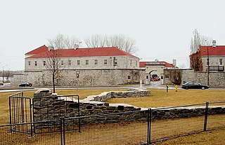
Fort Henry National Historic Site is located in Kingston, Ontario, Canada on Point Henry, a strategic, elevated point near the mouth of the Cataraqui River where it flows into the St. Lawrence River at the east end of Lake Ontario. The fort and the point on which the fort was built were named after Henry Hamilton, former Lieutenant-Governor of the Province of Quebec.
Fort Frontenac was a French trading post and military fort built in July 1673 at the mouth of the Cataraqui River where the St. Lawrence River leaves Lake Ontario, in a location traditionally known as Cataraqui. It is the present-day location of Kingston, Ontario, Canada. The original fort, a crude, wooden palisade structure, was called Fort Cataraqui but was later named for Louis de Buade de Frontenac, Governor of New France who was responsible for building the fort. It was abandoned and razed in 1689, then rebuilt in 1695.

King's Highway 2, commonly referred to as Highway 2, is the lowest-numbered provincially maintained highway in the Canadian province of Ontario, and was originally part of a series of identically numbered highways which started in Windsor, stretched through Quebec and New Brunswick, and ended in Halifax, Nova Scotia. Prior to the 1990s, Highway 2 travelled through many of the major cities in Southern Ontario, including Windsor, Chatham, London, Brantford, Hamilton, Burlington, Mississauga, Toronto, Oshawa, Belleville, Kingston and Cornwall, and many other smaller towns and communities.

The Kingston railway station is an inter-city passenger rail station in Cataraqui, Kingston, Ontario, Canada. It is served by Via Rail trains running from Toronto to Ottawa or Montreal, along the Corridor route. It is located on John Counter Boulevard, northeast of Princess Street and northwest of downtown Kingston.

The Kingston, Ontario Inner Harbour is situated at the south end of the Cataraqui River northeast of the downtown core of Kingston, Ontario, Canada. It is the section of Kingston Harbour that is north of the La Salle Causeway.
Pittsburgh is a former incorporated and now geographic township in Ontario, Canada. Located within Frontenac County, it was surveyed in 1787–1788 and named for William Pitt the Younger, the British prime minister. It was incorporated on January 1, 1850. The township was amalgamated into the city of Kingston effective January 1, 1998. The community still retains the name "Pittsburgh" within the government of Kingston.
Cataraqui Golf and Country Club is a private golf and curling club located in Kingston, Ontario, Canada. It was founded in 1917.

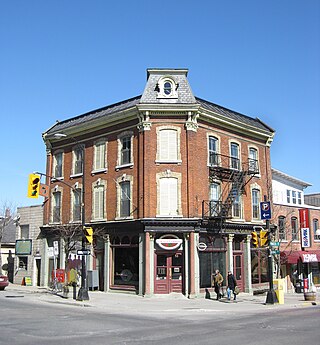
Princess Street is a major arterial road in Kingston, Ontario, Canada. As the main retail street of downtown Kingston, it is lined by many historic limestone buildings in the city's downtown core.

The Cherry Street Strauss Trunnion Bascule Bridge is a bascule bridge and Warren truss in Toronto, Ontario, Canada. Located in the industrial Port Lands area, it carries Cherry Street over the Toronto Harbour Ship Channel and opens to allow ships to access the channel and the turning basin beyond. There are two bascule bridges on Cherry Street. The other, smaller bridge, crosses the Keating Channel, while this bridge crosses the Ship Channel.
Inner Harbour is a neighbourhood located in downtown Kingston, Ontario, Canada. The Inner Harbour district is bounded by Joseph Street to the north, Princess Street to the south, Division Street on the west and the Cataraqui River on the east. The area is within the King's Town District. The District is represented on Kingston City Council by Councillor Rob Hutchison for the 2010-14 term of office.
Kingston Mills, located approximately 7 kilometres (4.3 mi) north of downtown Kingston, Ontario, is the southernmost lockstation and one of 24 lockstations of the Rideau Canal system. Kingston Mills is a component of the Rideau Canal National Historic Site, and along with the rest of the Rideau Canal, is a World Heritage Site. The site is managed and operated by Parks Canada.

Kingston City Hall is the seat of local government in Kingston, Ontario, Canada. Occupying a full city block facing Lake Ontario in Kingston's downtown, the city hall is a prominent building constructed in the Neoclassical style with a landmark tholobate and dome.
Point Frederick is a 41-hectare (101-acre) peninsula in Kingston, Ontario, Canada. The peninsula is located at the south end of the Rideau Canal where Lake Ontario empties into the St. Lawrence River. Point Frederick is bounded by the Cataraqui River to the west, the St. Lawrence River to the south, and Navy Bay to the east. The peninsula is occupied by the Royal Military College of Canada (RMC). Several of the buildings located on Point Frederick and the site of the old naval dockyard are national historic sites. Fort Frederick, at the south end of the peninsula, is a feature of the Kingston Fortifications National Historic Site of Canada.
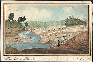
Captain Michael Grass (c.1734–1813) was a French-born militia captain who was loyal to the British and led a contingent of United Empire Loyalists to Canada after the American War of Independence. Grass was one of the founders of Kingston, Ontario.
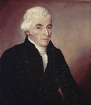
John Stuart was a Church of England clergyman, missionary, educator, and Loyalist. He is noted for being the first chaplain of the Legislative Council of Upper Canada, for being the first Anglican priest in what is now Ontario, for building the first church in what is now Kingston, Ontario, and for opening the first grammar school in Upper Canada.
Kingston Clippers was a Canadian semi-professional soccer club based in Kingston, Ontario. The club was founded as a youth soccer club and added its semi-professional club in League1 Ontario in 2014.
The Waaban Crossing is a 1.2-kilometre crossing of the Cataraqui River in Kingston, Ontario, linking John Counter Boulevard on the western side of the river with Gore Road on the eastern side. Built at a cost of $180 million, the bridge was funded by equal contributions from the city, provincial, and federal governments. The bridge opened to the public on December 13, 2022.

